Some drought conditions improve while others worsen amidst the heat: Southeast Weather Forecast – 7/24/22
Author: Gabriel Taylor
|| Published: 7/24/2022 at 9:23am
Overall a drier pattern is expected across the Southeast for the next three days with the exception of afternoon/evening thunderstorms in the thick of the heat. Sufficient surface moisture (dewpoints ranging from 70F-75F) and high precipitable water values (PWATs, 1.5″-2.0″) will allow for any storms that do develop to produce heavy rainfall, but these storms will pulse and be quick-hitters keeping overall rainfall amounts low.
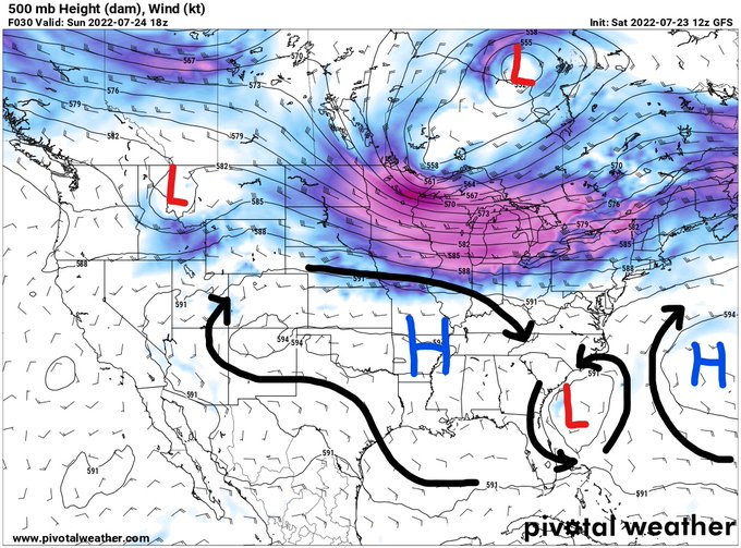
500mb ridging continues to sit over the South/Southeast with an area of high pressure set over parts of AR, Western TN, and NW MS keeping the weather relatively dry and hot. An upper level low (ULL) is drifting south-southwestward across the Florida Peninsula and will bring some higher precipitation amounts across parts of SC, GA, and Northern FL today and will weaken as it heads into the Gulf.
By the middle of next week the ridge will weaken and re-develop over the Western U.S. and in the Western Atlantic opening the door for some wetter weather next weekend.
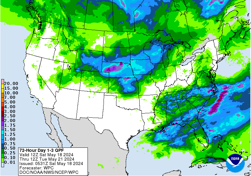
72-Hour Day 1-3 QPF // Courtesy: Pivotal Weather
Because of the ridge placement, most of the Southeast will experience lower-than-average precipitation over the next three days with slightly higher totals along the Gulf and Atlantic coastlines from daily sea-breeze fronts. Besides that, precipitation will come from afternoon/evening thunderstorms with some slightly higher coverage from the extra lift created by the ULL discussed in the previous paragraph.
U.S. Drought Monitor // Courtesy: National Drought Mitigation Center
The moderate drought conditions in GA, SC, and NC have improved over the past few days thanks to the tropical moisture in place; however, the drought has worsened across parts of TX, OK, and AR as the subtropical ridge has been circulating over the South keeping rainfall suppressed and temperatures above average. It’s hard to say when the severe and extreme drought condtions will begin to improve in Western TX/OK/AR, but there is a chance for some substantial rainfall later next weekend.
3-Day Southeast City Forecasts
Dallas, TX
Sunday
Monday
Tuesday
High: 101F
High: 103F
High: 103F
Low: 82F
Low: 81F
Low: 81F
Precip: None
Precip: None
Precip: None
Houston, TX
Sunday
Monday
Tuesday
High: 98F
High: 96F
High: 95F
Low: 79F
Low: 79F
Low: 78F
Precip: 20%
Precip: 20%
Precip: 30%
New Orleans, LA
Sunday
Monday
Tuesday
High: 91F
High: 90F
High: 91F
Low: 79F
Low: 79F
Low: 79F
Precip: 60%
Precip: 60%
Precip: 40%
Little Rock, AR
Sunday
Monday
Tuesday
High: 100F
High: 100F
High: 100F
Low: 79F
Low: 80F
Low: 80F
Precip: None
Precip: None
Precip: None
Memphis, TN
Sunday
Monday
Tuesday
High: 97F
High: 97F
High: 97F
Low: 78F
Low: 77F
Low: 77F
Precip: None
Precip: 30%
Precip: 30%
Birmingham, AL
Sunday
Monday
Tuesday
High: 93F
High: 92F
High: 91F
Low: 75F
Low: 74F
Low: 74F
Precip: 30%
Precip: 30%
Precip: 30%
Atlanta, GA
Sunday
Monday
Tuesday
High: 92F
High: 90F
High: 89F
Low: 73F
Low: 73F
Low: 74F
Precip: 40%
Precip: 40%
Precip: 60%
Author of the article:
Gabriel Taylor
Gabriel Taylor is an upcoming Junior studying Meteorology at Florida Institute of Technology. He enjoys forecasting and watching the weather whether it be in his hometown in New Jersey or at school in Florida.