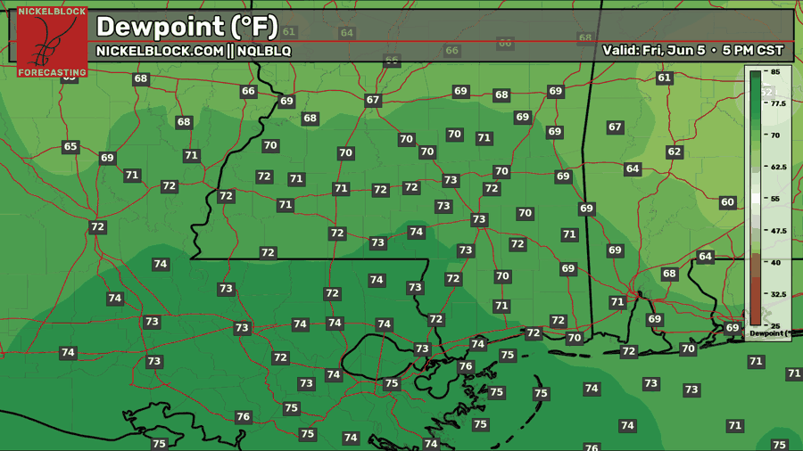
As I’m writing this, temperatures are generally in the mid 80s across our region, with a few scattered but weak thunderstorms in the Louisiana/Mississippi area. Similar to yesterday, there is a pronounced moisture gradient between the western part of our area and the eastern part of our area, with southwest Mississippi being the boundary between the two air masses.
Since yesterday, the humid air over Louisiana has moved a bit to the east.
Little rain will fall in the areas outside of Louisiana and southwest Mississippi. In those areas, the storms should be gone by 8 tonight. Tonight into tomorrow morning, the wind direction will shift slightly to the east, bringing some of the humid gulf air with it. As a result, tomorrow will be more muggy.
Later This Week
In general, this weekend and early next week will be stormier than the latter half of next week.
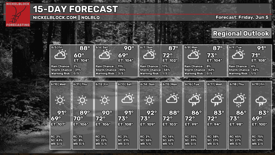
Unfortunately, Saturday and Sunday look to be the two rainiest days for our region. The rest of the week looks drier. Temperatures are forecasted to be near or slightly above normal next week, with many days seeing high temperatures over 90ºF.
The high pressure system which has brought us a couple nice days of pleasant temperatures and humidity will begin to move south over the gulf. This will lead to more humid air and daily weak thunderstorms over our region for this upcoming week.
A very typical pattern for summers in the south.
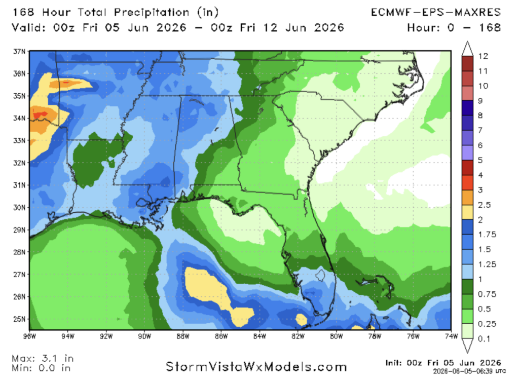
Rain totals will generally be near normal this week, with the highest amounts in the area north of New Orleans, northwest of Mobile, and south of Jackson.
Airport Forecast
KHOU/KIAH (Houston) – Current: temperature is 83ºF, dew point is 75ºF, skies are mostly cloudy, wind is coming out of the east at 9 mph, and visibility is 10 miles. Tonight: skies will remain cloudy with a slight chance of thunderstorms and the temperature will drop into the mid 70s. Very minor delays are possible.
KATL (Atlanta) – Current: temperature is 83ºF, dew point is 55ºF, skies are mostly cloudy, wind is coming out of the south at 8 mph, and visibility is 10 miles. Tonight: cloud cover will decrease as the night goes on, with no chance of rain or storms. Temperatures will drop into the mid 60s. No delays are likely.
KMSY (New Orleans) – Current: temperature is 82ºF, dew point is 75ºF, there is a light rain, wind is coming out of the east at 17 mph, and visibility is 10 miles. Tonight: the chance for storms and rain will persist into the night. Temperatures will drop into the mid 70s. Some delays are possible. There is also a coastal flood advisory currently in effect due to the gusty conditions which may cause some flooding along the coast of lake Pontchartrain.
KBTR (Baton Rouge) – Current: temperature is 87ºF, dew point is 72ºF, skies are partly cloudy, wind is coming out of the east at 13 mph, and visibility is 10 miles. Tonight: there is a chance for thunderstorms and showers which may cause some minor delays. Temperatures will drop into the mid 70s.
KSHV (Shreveport) – Current: temperature is 86ºF, dew point is 72ºF, skies are mostly cloudy, wind is coming out of the southeast at 18 mph, and visibility is 10 miles. Tonight: mostly cloudy skies will persist with a slight chance for thunderstorms, causing some very minor delays. Temperatures will drop into the lower-mid 70s.
KJAN (Jackson) – Current: temperature is 84ºF, dew point is 71ºF, skies are mostly cloudy, wind is coming out of the southeast at 8 mph, and visibility is 10 miles. Tonight: skies will be partly cloudy with no chance of storms/rain. Temperatures will drop into the low 70s. No delays are expected.
KBHM (Birmingham) – Current: temperature is 86ºF, dew point is 57ºF, skies are mostly sunny, wind is coming out of the west at 5 mph, and visibility is 10 miles. Tonight: skies will become partly cloudy with no chance of rain, so no delays are expected. Temperatures will drop into the mid 60s.
KMOB (Mobile) – Current: temperature is 83ºF, dew point is 69ºF, skies are mostly cloudy, wind is coming out of the southeast at 17 mph, and visibility is 10 miles. Tonight: gusty conditions will persist, with a small chance of thunderstorms/showers. Minor delays are possible due to wind as well as storms. Temperatures will drop into the low-mid 70s.
KTLH (Tallahassee) – Current: temperature is 87ºF, dew point is 56ºF, skies are partly cloudy, wind is coming out of the east at 7 mph, and visibility is 10 miles. Tonight: skies will clear up with no chance of rain. Temperatures will drop into the mid 60s. No delays are expected.
Highway Forecast
I-10: Thunderstorms may pass through the area between Houston and New Orleans bringing heavy rains, gusty winds, and lightning. Pull over if driving conditions are too poor. Most of these storms should be gone by 10 tonight. East of New Orleans, the chance of rain/storms is very low, so driving conditions should be good there.
I-20: Tonight, the chance of storms is mostly to the south. Along I-20, the greatest chance for storms tonight is near the TX/LA border near Shreveport, but even there the chance is low. As you go further east into MS, AL, and GA, there is little to no chance of rain, so driving conditions will be excellent.
I-49: The place with the greatest chance of storms tonight will be in the area between Lafayette and Natchitoches. Thunderstorms may bring heavy rain, gusty winds, and lightning. The chance for storms elsewhere is pretty low. The storm threat will be mostly gone by 10 tonight.
I-55: The storm threat tonight is very low in the TN portion as well as most of the MS portion, but storms may fire up this evening in the area between New Orleans and Jackson. The storm threat will be mostly gone by 10 tonight.
I-59: In Alabama and Georgia, the storm threat is almost non-existent. Once you cross into Mississippi, the storm threat increases, with northwest moving storms likely in that region this evening. Most of the storms will be gone by 10 tonight.
I-65: For all of the Tennessee portion and most of the Alabama portion of this highway, the storm threat is non-existent. The only place that may see storms fire up this evening is the Mobile area, but they should be gone by 9 tonight. Overall, excellent driving conditions are in store tonight for I-65.
I-75: For the entirety of the GA/FL portion of this highway, the storm threat is non-existent tonight, creating excellent driving conditions throughout.
3 Day City Forecast
Tallahassee, FL
Tomorrow: Skies will be mostly sunny tomorrow with a high of 91ºF. Winds will be coming out of the south tomorrow at 5-10 mph. Tomorrow night, winds will calm down a bit and temperatures will drop into the upper 60s. The air won’t feel too humid tomorrow, as the dew points are forecasted to be in the mid 60s throughout the day. The chance of rain tomorrow is very low.
Sunday: Skies will be mostly sunny on Sunday with a high of 92ºF. Winds will be coming out of the south/southeast in the morning but will shift to southerly at 5-10 mph throughout the day. Cloud cover will increase Sunday night, but the chance of rain is very low.
Monday: Partly sunny skies with a hot high of 95ºF. Mostly cloudy conditions as we reach Monday night. The wind direction may shift throughout the day Monday as the high pressure system over the gulf makes its way over the Florida panhandle. Chance of rain is low.
Birmingham, AL
Tomorrow: Tomorrow morning there is a chance of storms/showers. After that and before the evening, the high will get up to around 83ºF, then a second round of thunderstorms will likely roll through the area tomorrow evening and should be gone by 8 tomorrow night. Rain totals will generally be around half an inch, but some areas could see more than that. Temperatures will cool down to the low/mid 70s after the storms.
Sunday: A round of thunderstorms is in store Sunday morning. Most will pass by noon, then a secondary round of storms will pass by the area Sunday evening. High temperature will be around 84ºF, then will fall into the low/mid 70s at night.
Monday: Skies will be mostly cloudy during the day on Monday with a high of 83ºF. There is a chance of showers in the morning, then a chance of storms during the evening, although the strongest storms look to be further north. Temperatures will fall into the low 70s on Monday night.
Mobile, AL
Tomorrow: Skies will be cloudy tomorrow with a high of 84ºF. Some storms and showers are possible in the morning, but the greatest chance for rain will be tomorrow afternoon into the evening. Most storms should be gone by 9 pm. Temperatures will fall into the mid 70s tomorrow night.
Sunday: Skies will be cloudy on Sunday with a high of 85ºF. There is a chance for some showers and storms in the morning going into the afternoon, then scattered storms are likely from the mid-afternoon until evening. Most storms should be gone by 8 pm. Temperatures will fall into the mid 70s Sunday night.
Monday: Skies will be mostly on Sunday with a high of 89ºF. Cloud cover will increase at night, but the chance of rain is low. Temperatures will fall into the mid 70s Monday night.
Atlanta, GA
Tomorrow: Skies will be mostly sunny during the day tomorrow with a high of 88ºF. As night approaches, the cloud cover will increase, but no rain is likely. Winds throughout the day will be calm coming out of the south. Temperatures will fall into the upper 60s tomorrow night.
Sunday: Skies will be mostly cloudy during the day with a high of 84ºF. There is a slight chance of storms after midnight on Sunday. Winds will be calm throughout the day coming of the southwest in the morning, then becoming more northwesterly as the day goes on. Temperatures will drop down into the low 70s on Sunday night.
Monday: Skies will be mostly cloudy throughout the day, with a chance of showers and thunderstorms in the morning. High will reach 85ºF. A small chance of showers and storms persist on Monday night, when temperatures will drop down into the low 70s.
Jackson, MS
Tomorrow: The chance for storms will be for most of the day tomorrow, beginning in the late morning, and lasting until around 8, although most of the stronger storms will be further east. The high temperature will reach 85ºF. Winds will be coming out of the southeast for the entire day tomorrow. Temperatures will fall into the low 70s tomorrow night.
Sunday: There’s a chance of some showers and thunderstorms in the early morning, then another greater chance in the afternoon and evening. The high will reach 86ºF. Winds will be coming out of the southeast for most of the day, but will shift to be more southerly as the day goes on. Temperatures will drop down into the low 70s on Sunday night.
Monday: Mostly cloudy skies during the day, with a small chance for showers and storms in the afternoon and evening. The high will reach 88ºF. Winds will be calm and coming out of the southeast for the entire day. Temperatures will drop into the low 70s on Monday night.
New Orleans, LA
Tomorrow: The chance of storms will be high for most of the day tomorrow, with one round of storms in the morning and another in the evening. Rain totals could be significant in localized spots. The high will get up to 85ºF. Winds will be calm and coming out of the south for most of the day. Temperatures will only fall into the upper 70s tomorrow night.
Sunday: Scattered thunderstorms are possible Sunday morning going into the afternoon. The greatest chance of storms will be in the evening. The high will reach 86ºF. Winds will be relatively calm and coming out of the south for the entire day. Temperatures will fall into the mid-upper 70s Sunday night.
Monday: Partly sunny skies are in store for Monday during the day with a high of 87ºF. The chance of rain on Monday is low. Winds will be calm coming out of the southeast for most of the day. Cloud cover will increase as the day goes on, with temperatures falling into the mid-upper 70s on Monday night.
Baton Rouge, LA
Tomorrow: There’s a chance for scattered storms tomorrow morning. During the day, the storm threat decreases, but is still there, and increases again for the evening. The high will get up to 85ºF. Winds will be relatively calm coming out of the southeast, but will get more southerly as the day goes on. Temperatures will fall into the mid 70s tomorrow night.
Sunday: Scattered thunderstorms are likely Sunday evening. During the day, skies will be mostly cloudy with a high near 86ºF. Winds will be south/southeasterly for most of the day. Temperatures will fall into the mid 70s Sunday night.
Monday: Skies will be mostly cloudy during the day, with a chance of storms in the afternoon going into the evening. High temperature will reach 88ºF. Winds will be southerly during the day, but will become more southeasterly as the day goes on. Temperatures will drop into the mid 70s Monday night.
Shreveport, LA
Tomorrow: Mostly cloudy skies during the day, with a chance for storms in the afternoon going into the evening. High will be 87ºF. Winds will be calm and coming out of the southeast during the day, but will become more southerly as night approaches. Temperatures will fall into the mid 70s tomorrow night.
Sunday: Mostly cloudy skies during the day on Sunday, with a slight chance of showers and storms in the morning. Showers become likely in the afternoon and evening. High will reach 88ºF. Winds will be calm and southerly throughout the day. Temperatures will fall into the mid 70s on Sunday night.
Monday: Skies will be partly cloudy during the day on Monday with a high of 91ºF. There is also a slight chance for storms in the afternoon and evening. Winds will be southerly and calm in the morning, but will become more southwesterly as the day progresses. Temperatures will fall into the mid 70s Monday night.
Houston, TX
Tomorrow: Skies will be mostly cloudy tomorrow with a high of 87ºF. Some significant storms are likely in the afternoon going into the evening. Winds will be calm and southerly for most of the day. Temperatures will fall into into the mid-upper 70s tomorrow night.
Sunday: Skies will be partly cloudy during the day with a high of 89ºF. There is a slight chance of storms in the morning. Winds will be gusty during the day coming out of the south. Gusts could be up to 20 mph. Winds calm down as night approaches, where the temperature will only drop into the upper 70s.
Monday: Skies will be partly cloudy with a high near 90ºF. There will be a chance for some scattered storms during the afternoon and evening. Winds will be relatively calm coming out of the south for most of the day. Temperatures will fall into the mid-upper 70s Monday night.


