SPC issues High Risk with tornadoes, large hail possible
Author: Nick Lilja
|| Published: 5/18/2017 at 9:08am
The SPC is concerned about a severe weather outbreak across parts of Kansas and Oklahoma this afternoon and evening.
Here is the latest discusssion…
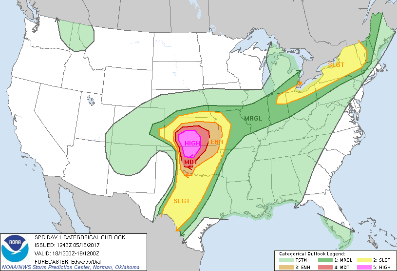
Day 1 Convective Outlook
NWS Storm Prediction Center Norman OK
0743 AM CDT Thu May 18 2017
Valid 181300Z – 191200Z
…THERE IS A HIGH RISK OF SEVERE THUNDERSTORMS FROM PARTS OF CENTRAL AND SOUTHERN KANSAS TO NORTHWESTERN OKLAHOMA…
…THERE IS A MODERATE RISK OF SEVERE THUNDERSTORMS SURROUNDING THE HIGH RISK FROM WESTERN OKLAHOMA TO CENTRAL KANSAS…
…THERE IS AN ENHANCED RISK OF SEVERE THUNDERSTORMS SURROUNDING THE
MODERATE RISK FROM PARTS OF NORTHWEST TEXAS TO PARTS OF SOUTHEASTERN
COLORADO…NORTHERN KANSAS AND EXTREME WESTERN MISSOURI…
…THERE IS A SLIGHT RISK OF SEVERE THUNDERSTORMS SURROUNDING THE
ENHANCED RISK AND EXTENDING INTO EASTERN COLORADO…WESTERN
MISSOURI…EXTREME SOUTHERN NEBRASKA…AND THE TEXAS RIO GRANDE
VALLEY NEAR DEL RIO…
…THERE IS A SLIGHT RISK OF SEVERE THUNDERSTORMS FROM NORTHEASTERN
INDIANA TO WESTERN NEW ENGLAND…
…THERE IS A MARGINAL RISK OF SEVERE THUNDERSTORMS SURROUNDING BOTH
SLIGHT RISKS AND BETWEEN THEM OVER THE MID MISSISSIPPI VALLEY…
SPC Day 1 Severe Weather Outlook
…SUMMARY…
An outbreak of severe thunderstorms with tornadoes, very large hail and wind damage is expected to develop across parts of the southern and central Plains from this afternoon into this evening and overnight. Some strong, long-lived tornadoes are expected, along with hail to near 4 inches in diameter, over parts of Kansas and Oklahoma. Large hail, tornadoes and wind damage also will be possible outside of these areas across parts of the southern and central Plains. Damaging gusts and sporadic hail also are expected across parts of the lower Great Lakes region to western New England this afternoon and early evening.
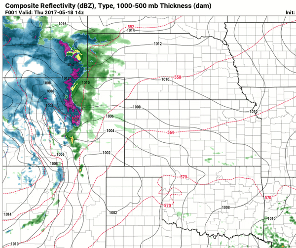
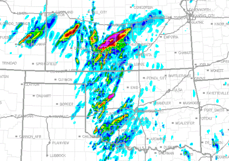
13z HRRR GIF // Graphic from Pivotal Weather
— Technical Discussion —
…Synopsis…
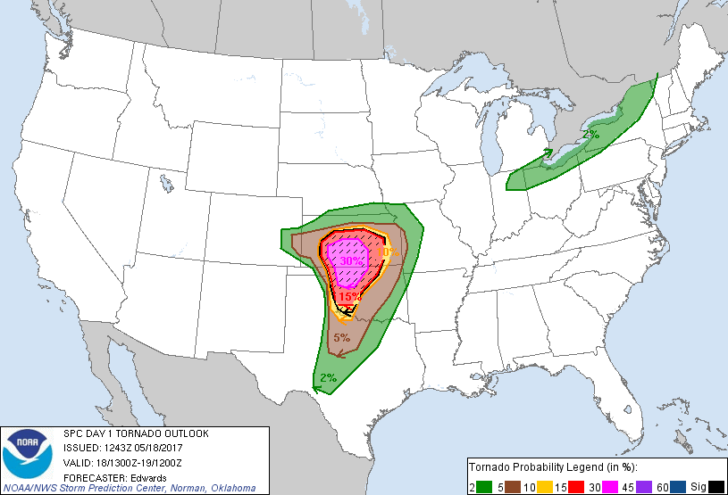
SPC Day 1 Severe Weather Outlook – Tornadoes
In mid/upper levels, broadly cyclonic flow will cover much of the western and central U.S., anchored by a major cyclone now centered over UT. The 500-mb low is expected to dig southeastward across the Four Corners through the period, reaching northwestern NM by the end of the period. As this occurs, the leading lobe of an 85-100-kt 250-mb jet will spread over the southern High Plains and western/central KS through tonight. A leading shortwave trough — currently apparent on moisture-channel imagery over WI, western Lake Superior and the MN Arrowhead — will weaken and eject east-northeastward across southern QC to northern ME by 12Z. At the surface, 11Z analysis showed a cold front from southern QC to a low over the MI/WI border, southwestward across IL, becoming quasistationary over MO and the KS/OK border region, to a weak low over southeastern CO. The low is expected to move erratically eastward along the KS frontal segment (becoming a slowly northward-moving warm front) through the period. Today, the richer low-level moisture now over north TX and southern/central OK will advect northwestward over the outlook area. The dryline will sharpen this afternoon from northern Coahuila northward across west-central TX to southwestern KS. The cold front will move southeastward across the Great Lakes region, reaching parts of NY, New England and the Ohio Valley region overnight.
…Central/southern Plains…
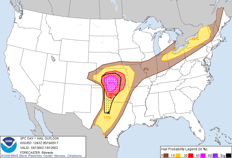
SPC Day 1 Severe Weather Outlook – Hail
Scattered thunderstorms, including multiple supercells with significant-tornado, giant-hail and damaging-wind potential, still appear probable this afternoon anywhere over the moderate- and high-risk areas, and possible farther south where coverage should be more widely scattered to isolated. The progged ingredient/parameter space is ideal for a multi-hazard severe-weather outbreak from the warm-frontal zone southward for 250-300 nm ahead of the dryline:
* Moderate to strong moisture and instability: moist advection of a rich Gulf air mass with 60s to near 70 deg F surface dew points, diurnally heated along/ahead of the dryline to remove CINH, beneath roughly 8 deg C/km midlevel lapse rates, yielding 3000-4500 J/kg MLCAPE. CAPE will diminish northward through the warm-frontal zone but the cut-off of surface-based inflow should be gradual, not abrupt.
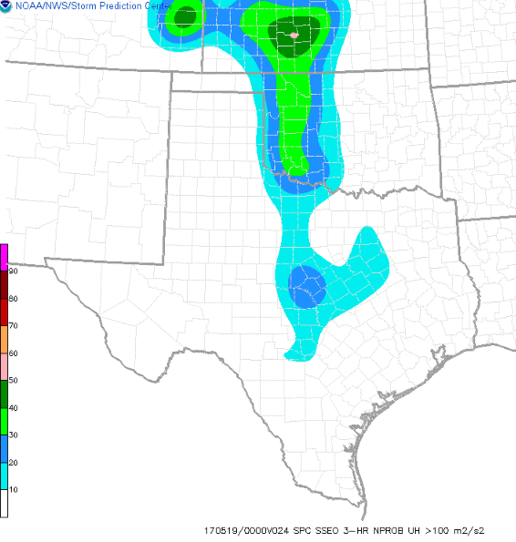
Percent chance of 100 m/s Updraft Helicity developing
* Favorable lift along the dryline and in the “bent-back” zone of deep forcing closer to the surface and upper lows
* Favorable low-level and deep-layer shear, especially near the warm front and low, but also southward across the moist sector. Low-level vorticity and hodograph size each will be maximized along and somewhat north of the warm front, with 300-400 J/kg effective SRH and 50-65 kt effective-shear magnitudes common. Any discrete/sustained supercells in this environment will be capable of cyclic, significant-tornado production as well as giant, destructive hail.
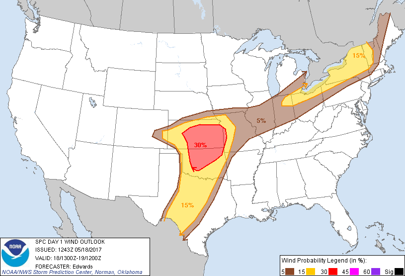
SPC Day 1 Severe Weather Outlook – Wind
A note of caution on this forecast: Some uncertainties still exist, however, precluding any greater probabilities at this time — mainly involving density and timing of convection. Initiation of too many cells in early/middle afternoon (before warm-sector hodographs and CAPE each are biggest), and/or too close to each other at once, is possible in some parts of the current moderate/high risks. This scenario, which some guidance suggests, would lend a greater wind threat and somewhat suppressed hail/significant-tornado risk with eastward extent, due to messier storm modes amidst strengthening deep-layer flow. Evidence for such a quick transition still is inconsistent in the bulk of numerical guidance, and of course observationally. While not compelling enough to modify the high or moderate risk-driving probabilities yet, this is a possibility to be monitored for potential adjustments to the outlook during the day. Regardless of timing, storm mergers and ultimate upscale growth of convective clusters appear likely, with embedded supercells, bows, and mesobeta- or smaller-scale damaging-wind swaths. Therefore, wind probabilities have been offset eastward somewhat, relative to the others.
Updraft Helicity this afternoon
…Northeast to mid Mississippi Valley… Widely scattered to scattered thunderstorms are expected to develop along and ahead of the front this afternoon as diabatic surface heating and low-level convergence zones (including the baroclinic zone) act against already weak MLCINH. Well-mixed subcloud layers beneath 1000-1500 J/kg MLCAPE, and the presence of 30-40 kt effective-shear magnitudes will support enough multicellular organization, and perhaps transient supercell structures, for a hail/wind threat. Nearly unidirectional prefrontal wind profiles are forecast, and some bowing clusters could develop that would enhance the wind-damage potential on smaller scales, especially over parts of NY or western New England, however, it is too soon to be specific enough with mesoscale details for a greater categorical corridor within the existing, somewhat eastward-expanded lines. The severe wind/hail threat will be more isolated, marginal and transient this afternoon and early evening southwestward toward the middle Mississippi Valley where warm-sector surface winds and frontal convergence each should be weaker.
Author of the article:
Nick Lilja
Nick is former television meteorologist with stints in Amarillo and Hattiesburg. During his time in Hattiesburg, he was also an adjunct professor at the University of Southern Mississippi. He is a graduate of both Oregon State and Syracuse University that now calls Houston home. Now that he is retired from TV, he runs this site and its app in his spare time.