LEt me ask you guys a question – and if you want to answer, you can either comment below, or over on facebook – these forecast write-ups have been pretty short lately and I was curious if anyone misses my big, long, write-ups with all the maps and charts and explanations? I usually only do those for the big events, but recently I’ve even shortened those a bit. Just curious!
Okay, on to today’s forecast: Damp.
There will be isolated and scattered storms across the area today.
Severe weather is less likely today, but a few storms may have some brief heavy rain, lightning, gusty wind and small hail. We can’t rule out a very, very brief tornado, but it would be one “for show” and isn’t likely to do much damage.
Looking at the sounding data for later today, I’ve made some highlights in yellow. We will have some good instabiity (but not a ton) with weak shear and some reasonable Downdraft CAPE. The hodograph isn’t much to look at, but there may be just enough wind the mid-levels to organize a storm or two.

This would leave us with the chance for a landspout to form under a storm. You may remember the most recent landspout back in August in the area.
Something like the above example may be possible. Recall that it did cause some damage, but most of it was cosmetic, and it didn’t hurt anyone seriously (at least that was reported).
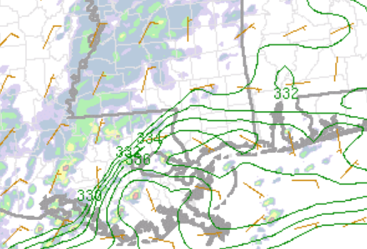
For today, the most likely area to see such an even would be along, or near, the lines in this graphic across Louisiana, Mississippi and Alabama.
Tomorrow will be similar rainwise with probably fewer storms. It will be a good light soaker based on the latest model guidance. A few heavy showers and rumbles of thunder mixed in (because it is April, I suppose) but the, technical, severe thunderstorm threat is basically zero.
Then this system moves out and we get ready for things to get drier. And weirder.
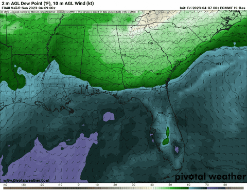
Looking at the dewpoint animation, you can see that we get some drier air to push into the area starting on Easter (that is the lighter greens, whites and browns). But then, off the coast and out into the Gulf, things start a’spinnin’.
That would be some sort of sub-tropical low pressure system developing. Both the Euro (shown above) and the GFS model are showing some sort of tropical/sub-tropical feature trying to spin up in the Gulf of Mexico during the next 10 days.
And that is weird. In fact. So weird, that it has never actually happened before.

And it is a bit odd to see in the model guidance given that – while the SSTs are warm – the Gulf isn’t in early-season or late season form. It is barely tagging 25C out over the loop current (which is rather robust for this time of year).


So, I don’t know that I’m necessarily ‘concerned’ about such an event occuring, but it is a curiosity, for sure. And even if something were to form into anything it would be very low-end and move quickly through the region leaving the potential for impacts at “rainy with gusty wind” which is really no different than today.
But hey, something to watch!
AG FORECAST
Here is a look at the Ag forecast for the next seven days…

REGIONAL DAY TO DAY FORECAST
Today: Mostly cloudy. A chance of showers with a slight chance of thunderstorms this morning, then showers likely with a chance of thunderstorms this afternoon. Highs in the upper 70s. Northeast winds 5 to 10 mph. Chance of rain 70 percent.
Tonight: Showers likely with a chance of thunderstorms. Lows in the lower 60s. Northeast winds 5 to 10 mph. Chance of rain 70 percent.
Saturday: A chance of thunderstorms. Showers. Highs in the lower 70s. Northeast winds 5 to 10 mph. Chance of rain 80 percent.
Saturday Night: Mostly cloudy. A slight chance of showers and thunderstorms in the evening. Lows in the mid 50s. Northeast winds around 10 mph. Chance of rain 20 percent.
Sunday: Mostly cloudy. Highs in the upper 60s. Northeast winds 10 to 15 mph.
Sunday Night: Mostly cloudy. Lows in the mid 50s.
Monday: Mostly cloudy. Highs in the upper 60s.
Monday Night: Mostly cloudy. Lows in the mid 50s.
Tuesday: Mostly cloudy in the morning, then becoming partly sunny. Highs in the upper 60s.
Tuesday Night: Mostly cloudy. Lows in the mid 50s.
Wednesday: Partly sunny with a few showers possible. Highs in the lower 70s. Chance of rain 30 percent.
Wednesday Night: Partly cloudy. Lows in the mid 50s.
Thursday: Partly sunny. Highs in the mid 70s.


I’ve learned that information is like coffee … you can never have too much of it. I’ll admit that some of the ‘explanations’ are a little difficult to understand but, I would vote to continue to have it or, at least, for the BIG events as you put it. With that said, only do what you have time for and what your job allows. At the very least, continue using the Karrie Meter … MOST valuable! As for the low in the Gulf, you must have read my mind because I was going to ask you if you’ve ever seen one, whether it is tropical or sub-tropical, this early. I knew ‘I’ had not. Just hope it’s not a sign of things to come.
Yes. I do miss the graphics. I was trying to keep tabs on the hail risk.
I looked them up on your “severe weather ” link.
I appreciate the time you spend giving us the information we need.
You are right up there with James Spann (Birmingham’s weather man)