The front that pressed through the area the other day is now lifting back to the north. And later today and will shift back to the south again. As it places ‘ring-around-the-rosey’ with the region, it will push rain here and there along with it.
Showers and storms this morning are still, mainly, off to the west. That will change as we move through the morning and into the afternoon. For the most part today, though, it looks like most of the rain (but not all of the rain) will be west of I-59. Overnight tonight it will start to really spread east, and then we are all going to be ‘singing in the rain’ tomorrow.
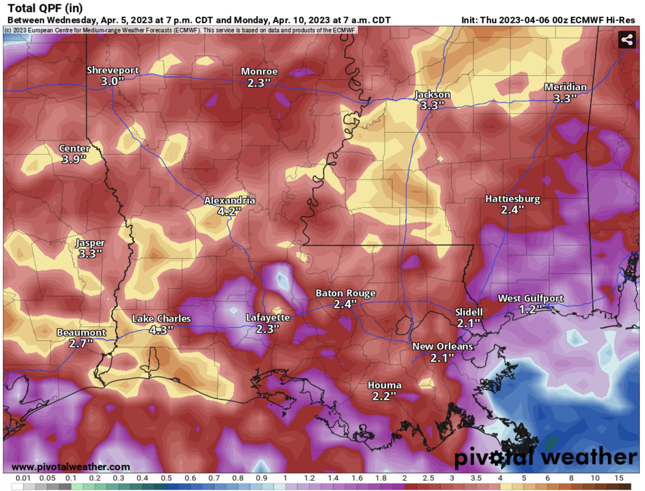
That will last through most of Saturday before we dry things out for Easter Sunday. Rainfall totals now look to be between about 1″ to 3″ of additional rainfall. I will note, though, that while there won’t be water falling from the sky, there will still be plenty on the ground on Sunday. So any outdoor Easter Egg hunts may need to be moved inside
Then we should stay dry for Monday, Tuesday and Wednesday of next week.
REGIONAL DAY TO DAY FORECAST
Today: Mostly cloudy this morning, then becoming partly sunny. A chance of showers with a slight chance of thunderstorms. Highs in the mid 80s. Southeast winds 5 to 10 mph. Chance of rain 50 percent.
Tonight: Mostly cloudy with a chance of showers with a slight chance of thunderstorms. Lows in the mid 60s. East winds 5 to 10 mph, becoming northeast after midnight. Chance of rain 50 percent.
Friday: Cloudy with a slight chance of thunderstorms. A chance of showers in the morning, then showers likely in the afternoon. Highs in the upper 70s. Northeast winds 5 to 10 mph. Chance of rain 70 percent.
Friday Night: Showers with a chance of thunderstorms. Lows in the lower 60s. Northeast winds 5 to 10 mph. Chance of rain 90 percent.
Saturday: A chance of thunderstorms. Showers. Highs in the lower 70s. Northeast winds 5 to 10 mph, becoming northwest in the afternoon. Chance of rain 90 percent.
Saturday Night: Mostly cloudy. Lows in the mid 50s.
Sunday: Mostly cloudy. Highs in the upper 60s.
Sunday Night: Mostly cloudy. Lows in the lower 50s.
Monday: Partly sunny. Highs in the lower 70s.
Monday Night: Partly cloudy. Lows in the lower 50s.
Tuesday: Mostly sunny. Highs in the mid 70s.
Tuesday Night: Mostly clear. Lows in the lower 50s.
Wednesday: Sunny. Highs in the upper 70s.


