Things stay calm for the next few days, but just in time for the ned of the week we have another shot for storms and severe weather.
The SPC has sections of the area highlighted with a Slight Risk for severe weather on Thursday (Day 2) and the rest of the area under a Slight Risk on Friday (Day 3). A Slight Risk is a “2” on the 1-to-5 scale where “5” is the highest risk for the most significant severe weather.
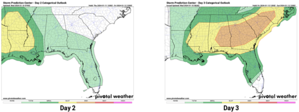
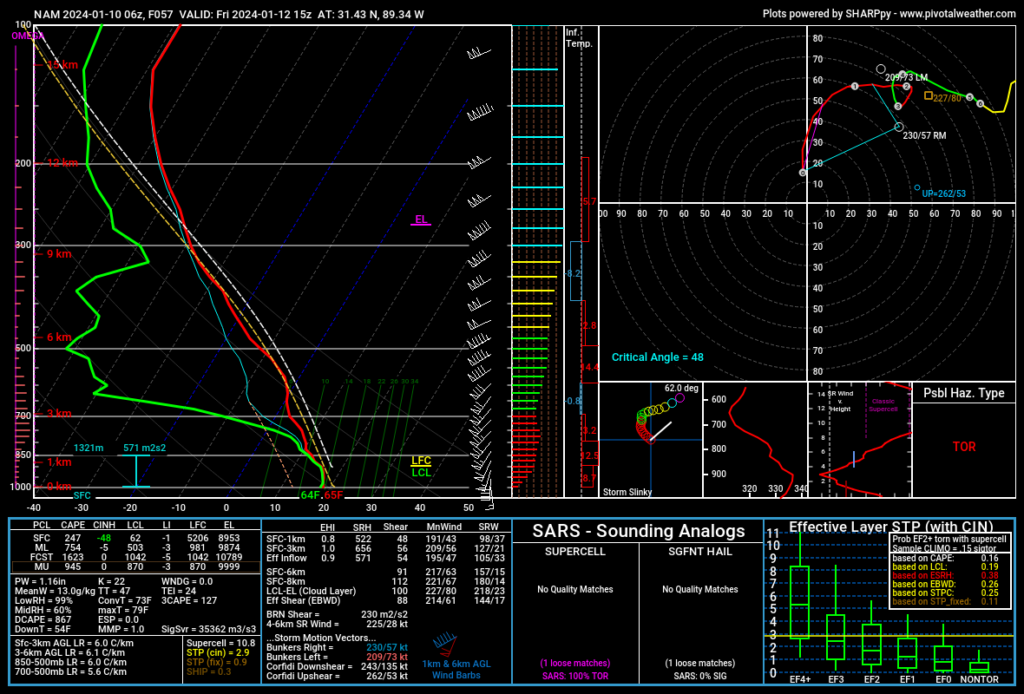
Looking at the model data, and it looks more like a Spring severe weather Skew-T than something we would see in January. Given what I’m seeing, I tend to think that we will see a brief window for severe weather Friday morning. And it will likely be along or near a line of thunderstorms set to move through the area.
Currently it looks less likely to see a bunch of showers and storms ahead of the line. But, if we do see a storm develop ahead of the line, it would pose a risk for turning severe.
Once we get through the storms, I know everyone’s mind is really on the shot of cold air shown across the weather models and ripping through Social Media like wildfire.
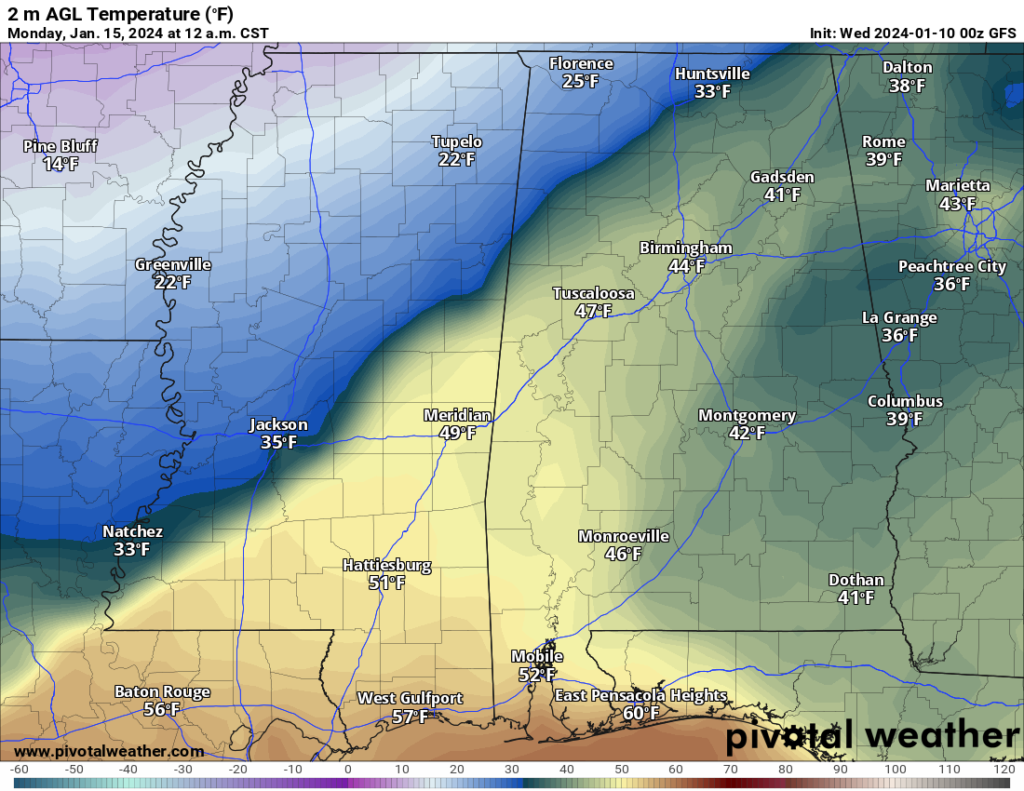
I even got a message from a someone pointing out that a historically reputable weather outlet was showing snow – and a lot of snow – for parts of the area.
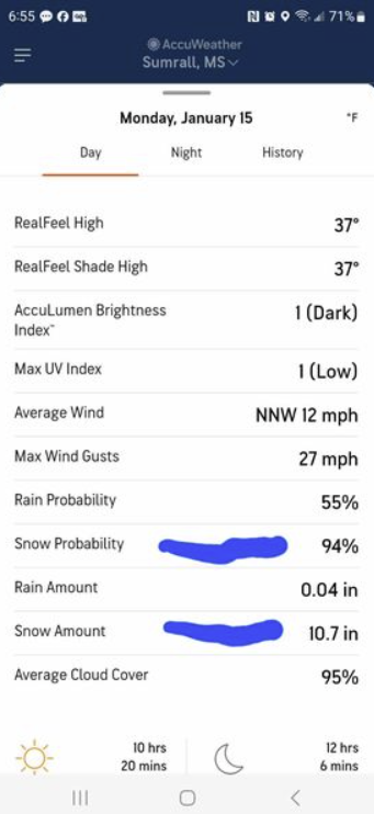
The problem with the chance for “big snow” is there currently isn’t enough moisture available. Generally we use a 10:1 ratio for snow where 1″ of rain equal 10″ of snow. And we figure that out by melting 10″ of snow to see how much rain we get. In the mountains of Colorado you can get 20:1 snow (really dry) and the Great Lakes can see 5:1 snow (very wet).
In December of 2017, the Pine Belt saw a snow ratio of 6:1 where the 6″ of snow melted into 1″ of rain.
In the screengrab here it shows 0.04″ of rain from 10.7″ of snow. That would be super duper dry snow. That is a 250:1 ratio!
And that, really, isn’t physically possible (at least that I’m aware).
So, I think preparing for some colder air is fine, but preparing for any meaningful snow is still a bit too early. Could there be any frozen precip? There could. But I don’t think we have enough clarity to say what kind, how much and where quite yet.
REGIONAL DAY-TO-DAY FORECAST
Today: Sunny, then becoming mostly sunny this morning, then becoming sunny. Highs in the mid 50s. Southwest winds 5 to 10 mph. Gusts up to 20 mph after midnight.
Tonight: Mostly clear in the evening, then becoming mostly cloudy. Lows in the upper 30s. South winds around 5 mph.
Thursday: Mostly sunny. Not as cool with highs in the upper 60s. Southeast winds 5 to 10 mph.
Thursday Night: Mostly cloudy. Showers likely with a slight chance of thunderstorms after midnight. Not as cool with lows in the mid 50s. Temperature rising into the lower 60s after midnight. Southeast winds 10 to 15 mph. Gusts up to 25 mph, increasing to 35 mph after midnight. Chance of rain 70 percent.
Friday: Mostly cloudy with showers with a chance of thunderstorms in the morning, then mostly sunny with a slight chance of showers in the afternoon. Breezy with highs in the lower 70s. Temperature falling into the lower 60s in the afternoon. South winds 15 to 25 mph, becoming west 20 to 25 mph in the afternoon. Gusts up to 45 mph. Chance of rain 90 percent.
Friday Night: Mostly clear. Much colder with lows in the lower 30s.
Saturday: Sunny. Much cooler with highs in the lower 50s.
Saturday Night: Mostly clear. Cold with lows in the lower 30s.
Sunday: Sunny. Highs around 60.
Sunday Night: Partly cloudy with a slight chance of showers in the evening, then mostly cloudy with a chance of showers after midnight. Not as cool with lows in the lower 40s. Chance of rain 30 percent.
Martin Luther King Jr Day: Partly sunny with a 40 percent chance of showers. Highs in the upper 50s.
Monday Night: Mostly cloudy. A chance of rain showers, mainly in the evening. Much colder with lows in the lower 20s. Chance of rain 30 percent.
Tuesday: Mostly sunny. Much cooler with highs in the lower 40s.


