We have had some minor changes overnight. It looks like we will have a shot for showers and storms today with the potential for some severe weather, too. Models overnight have collected around the RRFS ensemble model showing a single, messy, line of storms crashing through the area.
The “General forecast for the area” still holds:
EVERYONE — Brief heavy rain, some lightning, wind gusts up to 40mph
MOST FOLKS — A few rounds of brief heavy rain, brief flash flooding, lightning, wind gusts up to 50mph
SOME SPOTS — A few rounds of extended heavy rain, brief flash flooding, a lot of lightning, wind gusts up to 60mph, small hail
FEW PLACES — A few rounds of extended heavy rain, brief flash flooding, a lot of lightning, wind gusts up to 65mph, ping-pong ball sized hail
VERY SELECT LOCATIONS — A few rounds of extended heavy rain, brief flash flooding, a lot of lightning, wind gusts up to 65mph, ping-pong ball sized hail and a tornado
I will say this: These “messy lines” of storms can have a pretty low floor and a pretty high ceiling depending on how things evolve during the say that isn’t always something the model guidance – nor the meteorologists – can forecast. This is why I’ve been harping on the “some folks will go to bed tonight with only a little rain while other will go to bed after something that would make Noah, on his Ark, worry.”
And we are riding a see-saw between flooding and severe weather. As one goes up the other comes down, and vice-versa. So know that, on a day like today, if it starts raining, and raining, and raining, and raining, the risk for severe weather should subside a bit. But if we are starting around with only some rain here and some rain there, then the risk for severe weather goes up.
Okay – with all of that said! On to the forecast!
The changes in the froecast from yesterday are reflected in the timeline. Storms may start about an hour – or two – earlier than I was thinking yesterday morning. I’ve updated the timeline to reflect that.

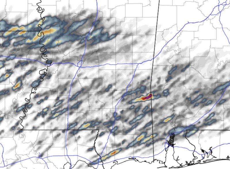
Here is an animation of the RRFS model. I tried to slow it down as much as I could. I’ve been working on resolving the issue where the animation can’t be stopped and rolled back-and-forth. Hang in there, that will come back!
We will have a chance for “all modes” of severe weather today. Heavy rain, flash flooding, lightning, damaging wind gusts, large hail and tornadoes.
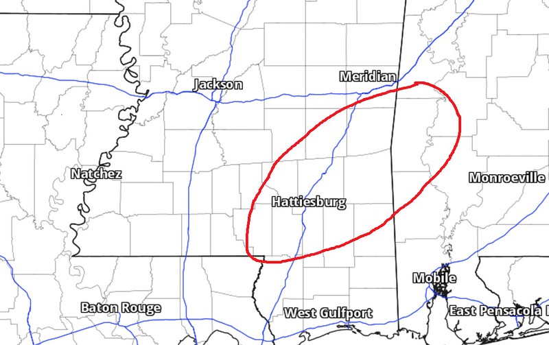
I’m going to leave the Storm Threats Timeline “as-is” from last night but know that storms may fire up about an hour or two earlier depending on your location. The farther NW you live, the earlier the storms will start, the farther southeast you live the later they will start. .

Another unchanged part of the forecast is where I think the strongest storms of the day will develop. The HRRR and RRFS models both indicate the severe weather parameters overlap with the greatest frequency in this area. Also, this is going to be ahead of the leading edge of the line of storm when they are the most broken, allowing for discrete storm development.
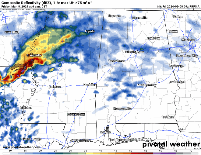
OF note,t eh Updraft Helicity streaks map does show a good number of ‘splotches’ in our area. but it does show many – if any at all – longer streaks. That means storms may be ‘pulsy’ and long-track tornadoes and long-track severe storms are less likely given this data.
While I always say (and I mean it!) not to focus on individual UH streaks on the map, notice, though, that the above map does still highlight the same areas with the highest density of splotches in the same area as I highlighted last night – albeit perhaps a bit farther east and south.
I’ll continue to monitor model trends and keep an eye on radar as best I can for everyone today. Make sure you have the NickelBlock Forecasting Weather App on your phone if you’d like to get pings fromt eh NWS when watches and warnings are posted. It also has a new, and improved radar, as well as access to this forecast (and others like it) any time you need it!
REGIONAL DAY TO DAY FORECAST
Today: Cloudy with storms this afternoon Some storms may be severe. Highs in the mid 70s. Southeast winds 15 to 20 mph with gusts up to 35 mph. Chance of rain 90 percent.
Tonight: Showers with thunderstorms likely in the evening, then showers likely with a chance of thunderstorms after midnight. Some thunderstorms may be severe in the evening. Lows in the mid 60s. South winds 15 to 20 mph with gusts up to 35 mph. Chance of rain 80 percent.
Saturday: Cloudy with a few lingering showers in the morning possible. Highs in the mid 70s. West winds around 10 mph, becoming northwest in the afternoon. Chance of rain 20 percent.
Saturday Night: Mostly cloudy. Much cooler. Less humid with lows in the upper 40s. North winds around 10 mph.
Sunday: Mostly sunny. Highs in the mid 60s. North winds 5 to 10 mph.
Sunday Night: Mostly cloudy. Lows in the lower 40s.
Monday: Mostly sunny. Highs in the upper 60s.
Monday Night: Mostly clear. Lows in the lower 40s.
Tuesday: Mostly sunny. Highs in the lower 70s.
Tuesday Night: Partly cloudy. Lows in the upper 40s.
Wednesday: Mostly sunny. A slight chance of showers in the afternoon. Highs in the upper 70s. Chance of rain 20 percent.
Wednesday Night: Partly cloudy in the evening, then becoming mostly cloudy. Not as cool with lows in the upper 50s.
Thursday: Mostly cloudy. A slight chance of showers in the morning, then a chance of showers in the afternoon. Highs in the upper 70s. Chance of rain 30 percent.


