Here is a brief forecast:
EVERYONE — Brief heavy rain, some lightning, wind gusts up to 40mph
MOST FOLKS — A few rounds of brief heavy rain, brief flash flooding, lightning, wind gusts up to 50mph
SOME SPOTS — A few rounds of extended heavy rain, brief flash flooding, a lot of lightning, wind gusts up to 60mph, small hail
FEW PLACES — A few rounds of extended heavy rain, brief flash flooding, a lot of lightning, wind gusts up to 65mph, ping-pong ball sized hail
VERY SELECT LOCATIONS — A few rounds of extended heavy rain, brief flash flooding, a lot of lightning, wind gusts up to 65mph, ping-pong ball sized hail and a tornado
Tomottor may be a bit of a boom-or-bust day for some folks. I think there may be a few spots that get through tomorrow and wake up Saturday morning having only seen a brief round of rain and heard a few rumbles of thunder, while other may have a pretty rough day.
This will only be a quasi-county by county forecast because for clusters of counties in the area, the forecast is going to be so close to the same that it is a bit of a waste of time to break them out into individual pieces.
So far, tonight’s data looks a lot like the data from this morning with some minor adjustments. It looks like storms are going to be showing up about an hour or two sooner and the ceiling is a bit higher with respect to severity.
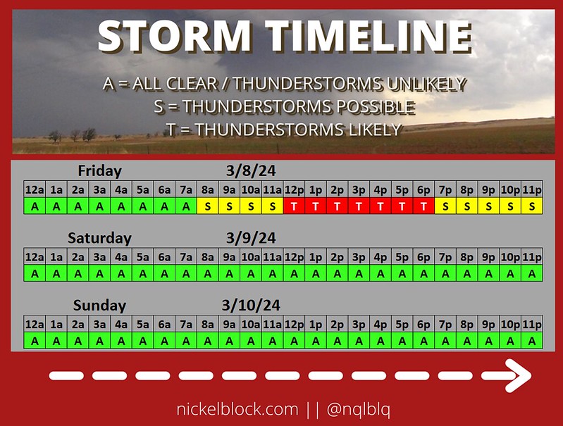
I put together a quick chart to highlight when I think the strongest storms will develop based on teh latest high-resolution model data. This is a general look across the area. I think it is likely after lunch and through about the dinner our and then things tail off as we move through the evening. The severe threat will end about 11p or shortly thereafter.

In terms of individual storms threats, I think we are looking at the entire gambit, unfortunately.
Using the same color-coding as the timeline, I’ve broken things down in the chart below. Heavy rain and some flash flooding will be possible. There will be plenty of lightning. Wind tomorrow will be sustained around 20mph at times which means wind gusts to 40mph will be pretty commonplace in storms. Wind gusts up over 60mph in the severe storms will be possible, too.

Hail and tornadoes will be most likely between about 1p and 6p tomorrow with a lingering threat through 8p or 9p. And it looks like we may have two chances for tornadoes stronger than EF-2. The first window will be around 1p till 3p and the second will be between 6p and 9p. But I think the second window may have a pretty sharp cut-off depending on how things evolve during the day.
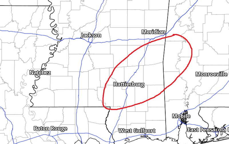
Ont he map, when you look at all of the available data tonight, I think the area circled in red below offers the best bet for seeing the strongest of the storms tomorrow.
Looking at the data, the Karrie Meter is back down slightly tonight with the addition of a few more models into the mix. The “TOR LEAN” has also come back down to nearly the same number as the Karrie Meter meaning that tornadoes are not “more likely” than normal, nor are they “less likely” than normal for a situation like this.

In short: Tomorrow will feature a chance for severe weather. Not everyone will get the worst-of-the-worst, but some folks will. Be prepared for the NWS to issue some sort of Watch and some sort of Warning for your area or areas nearby.
COUNTY-BY-COUNTY FORECAST
Like I said, this will be in clusters since the forecast is similar in many spots for this setup.
Rankin, Simpson, Scott, Smith, Newton, Jasper, and Lauderdale Counties
7a — 11a – As things get started, a few isolated storms are possible. A few may be severe. The main concerns are brief heavy rain, some lightning, gusty wind, small hail. Rainfall totals up to 1 inch possible.
12p — 4p – There is a chance for showers and storms. Some severe. the main concerns are heavy rain, frequent lightning, wind gusts up to 60mph, ping pong ball-sized hail, and a few brief tornadoes. Rainfall totals are estimated to be around 1-3 inches.
5p — 9p – There is a chance for showers and storms. Some severe. the main concerns are heavy rain, frequent lightning, wind gusts up to 60mph. Rainfall totals are estimated to be around 2-4 inches.
10p — 1a – All Clear! Though, there is a chance for some lingering brief heavy rain, some lightning, gusty wind, small hail. Rainfall totals up to 1 inch possible.
How it will impact you:
– Roads may be briefly impassable due to short-term flash flooding
– With a lot of lightning expected, make sure to be inside
– Tree limbs may come down with some power outages possible
– A Tornado Watch is possible
Lamar, Covington, Forrest, Jones, Perry, Greene, Wayne, and Clarke Counties
7a — 11a – As things get started, a few isolated storms are possible. A few may be severe. The main concerns are brief heavy rain, some lightning, gusty wind, small hail. Rainfall totals up to 1 inch possible.
12p — 4p – There is a chance for showers and storms. Some severe. the main concerns are heavy rain, frequent lightning, wind gusts up to 60mph, ping pong ball-sized hail, and a few tornadoes (up to EF3 in strength). Rainfall totals are estimated to be around 1-3 inches.
5p — 9p – There is a chance for showers and storms. Some severe. the main concerns are heavy rain, frequent lightning, wind gusts up to 60mph, quarter-sized hail, and a few tornadoes (up to EF2 in strength). Rainfall totals are estimated to be around 1-3 inches.
10p — 1a – All Clear! Though, there is a chance for some lingering brief heavy rain, some lightning, gusty wind, small hail. Rainfall totals up to 1 inch possible.
How it will impact you:
– Roads may be briefly impassable due to short-term flash flooding
– With a lot of lightning expected, make sure to be inside
– Tree limbs may come down with some power outages likely
– Hail damage is possible, park vehicles under cover if possible
– A Tornado Watch is likely
Pike, Walthall, Marion, Lawrence, and Jeff Davis Counties
8a — 12p – As things get started, a few isolated storms are possible. A few may be severe. The main concerns are brief heavy rain, some lightning, gusty wind, small hail. Rainfall totals up to 1 inch possible.
1p — 5p – There is a chance for showers and storms. Some severe. the main concerns are heavy rain, frequent lightning, wind gusts up to 60mph, ping pong ball-sized hail, and a few brief tornadoes. Rainfall totals are estimated to be around 1-3 inches.
6p — 10p – All Clear! Though, there is a chance for some lingering brief heavy rain, some lightning, gusty wind, small hail. Rainfall totals up to 1 inch possible.
How it will impact you:
– Roads may be briefly impassable due to short-term flash flooding
– With a lot of lightning expected, make sure to be inside
– Tree limbs may come down with some power outages possible
– Hail damage is possible, park vehicles under cover if possible
– A Tornado Watch is possible
Pearl River, Stone, George, Harrison, Hancock, and Jackson Counties
10a — 1p – As things get started, a few isolated storms are possible. A few may be severe. The main concerns are brief heavy rain, some lightning, gusty wind, small hail. Rainfall totals up to 1 inch possible.
2p — 6p – There is a chance for showers and storms. Some severe. the main concerns are heavy rain, frequent lightning, wind gusts up to 60mph, and a few brief tornadoes. Rainfall totals are estimated to be around 1-3 inches.
6p — 9p – There is a chance for showers and storms. Some severe. the main concerns are heavy rain, frequent lightning, wind gusts up to 60mph, and a few brief tornadoes. Rainfall totals are estimated to be around 1-3 inches.
10p — 2a – All Clear! Though, there is a chance for some lingering brief heavy rain, some lightning, gusty wind, small hail. Rainfall totals up to 1 inch possible.
How it will impact you:
– Roads may be briefly impassable due to short-term flash flooding
– With a lot of lightning expected, make sure to be inside
– Tree limbs may come down with some power outages possible
– A Tornado Watch is possible
Tangipahoa, Washington, and St. Tammany Parishes
8a — 12p – As things get started, a few isolated storms are possible. A few may be severe. The main concerns are brief heavy rain, some lightning, gusty wind, small hail. Rainfall totals up to 1 inch possible.
1p — 5p – There is a chance for showers and storms. Some severe. the main concerns are heavy rain, frequent lightning, wind gusts up to 60mph, quarter-sized hail, and a few brief tornadoes. Rainfall totals are estimated to be around 1-3 inches.
6p — 10p – All Clear! Though, there is a chance for some lingering brief heavy rain, some lightning, gusty wind, small hail. Rainfall totals up to 1 inch possible.
How it will impact you:
– Roads may be briefly impassable due to short-term flash flooding
– With a lot of lightning expected, make sure to be inside
– Tree limbs may come down with some power outages possible
– Hail damage is possible, park vehicles under cover if possible
– A Tornado Watch is possible


