Another morning of fog across the area. Most folks should get out of this morning with little consequence, but other low-lying areas may look like pea soup. Once the fog clears, things look rather warm for today, with afternoon highs in the 70s and low 80s.
Then things start to get interesting as we move through the day on Friday.
At the moment, model guidance suggests that a warm front kicks through the area during the morning and into the afternoon on Friday. As it does so, it will spark off some showers and storms. The amtosphere likes to get rather spinny around warm fronts, so we may see a handful elevated storms produce gusty wind and small hail as it passes through.
Once we are into the “Warm sector” of the system (after the warm front passes us), then we will need to look out for isolated well-organized storms. I don’t think these severe storms will be very widespread at all. I think we may see, like, 3 or 4 of these and that’s all. But the three or four we have, will have the opportunity to get rooted and become surface-based offering every type of severe weather (rain, wind, hail and tornadoes).
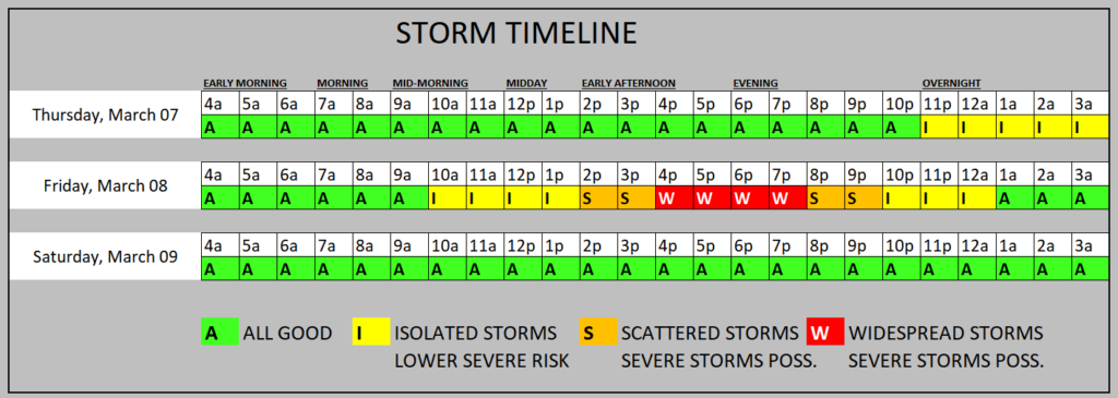
The timeline shows the highest risk for severe weather to be between “4p and 8p” but I’m going to stretch that another hour in both directions for the Karrie Meter just in case we see a discrete storm fire up early. And if we get one or two storms rooted, they’ll likely hold on a bit longer, too, so I’ll hold the timeline an hour later, too.
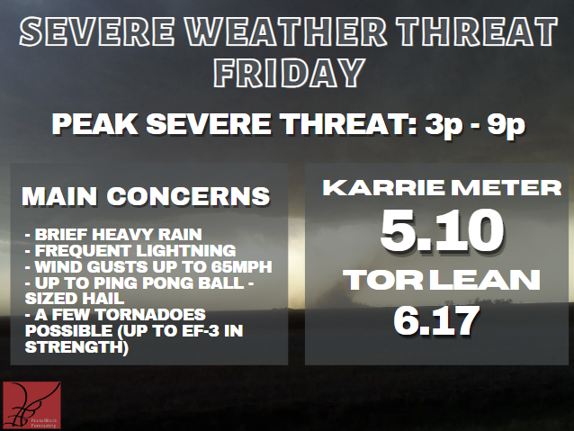
The other change you may notice is the Karrie Meter is up another point-and-change, at a 5.10 today compared to the 3.95, yesterday. And the “TOR LEAN” has shot way up from a 2.01. And the “TOR LEAN” is a relative scale, so “2” isn’t always lower than “6” because it is relative to the Karrie Meter number.
When it is higher than the Karrie Meter, tornadoes are more likely than normal in this type of situation and when it is a lower number, the potential is lower than normal for a given situation.
That means, during the last 24 hours as some of the higher-resolution model guidance has come in, it is showing a higher chance for surface based storms, relative to the global, lower-resolution model guidance.
A quick note about a lot of the scary maps you’re likely to see on TV and floating around the internet during the next 24 hours: Make sure you’re looking in the right places.
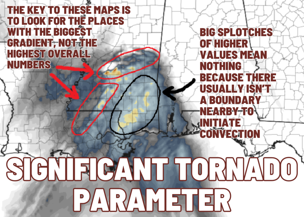
Often TV meteorologists will focus on the highest values in the middle of a blob of bright colors – those don’t matter as much. Sure, it gives you an idea about the general atmosphere, but in terms of the near-storm environment, they are meaningless.
Looking for the biggest gradient will give you a good idea about where the storms will be and what the storms will have access to use. In this case, the map above is for 9p on Friday night. It shows the highest gradient along I-20 and back down I-55 in Mississippi.
If this model is accurate (which it probably isn’t ‘completely’ accurate, to be fair), those are the places I would be looking during that time period for the strongest storms – not the big blob.
So why do TV meteorologists do this? Probably two fold. One, they don’t know how to read the data on the map. And two, brighter colors get your attention.
Apologies for being a bit of a crank this morning, but you deserve better information than what you are often served.
Am I always 100% accurate? No. But does my analysis come with thorough vetting of data and from a place of honesty? Yes. I simply wish more people who claim to communicate ‘for the public good’ would actually care about what is good for the public.
REGIONAL DAY TO DAY FORECAST
Today: Patchy fog this morning. Mostly sunny. Highs in the upper 70s. East winds 5 to 10 mph, becoming southeast this afternoon.
Tonight: Mostly cloudy. Lows in the upper 50s. Southeast winds around 5 mph.
Friday: Mostly cloudy with storms possible – mainly in the afternoon. Storms may be severe. Highs in the mid 70s. Southeast winds 15 to 20 mph with gusts up to 30 mph. Chance of rain 70 percent.
Friday Night: Showers with thunderstorms likely. Some storms may be severe. Near steady temperature in the upper 60s. South winds 15 to 20 mph with gusts up to 30 mph. Chance of rain 90 percent.
Saturday: Mostly cloudy. A chance of showers and thunderstorms, mainly in the morning. Highs in the mid 70s. West winds around 10 mph, becoming northwest in the afternoon. Chance of rain 20 percent.
Saturday Night: Mostly cloudy. Much cooler with lows in the upper 40s.
Sunday: Mostly sunny. Cooler with highs in the mid 60s.
Sunday Night: Partly cloudy. Lows in the lower 40s.
Monday: Mostly sunny. Highs in the upper 60s.
Monday Night: Mostly clear in the evening, then becoming partly cloudy. Lows in the lower 40s.
Tuesday: Mostly sunny. Highs in the lower 70s.
Tuesday Night: Mostly cloudy. Lows around 50.
Wednesday: Mostly sunny with a 20 percent chance of showers. Highs in the mid 70s.


We appreciate you so much especially when bad weather is expected…I always look for you on FB for accurate information not entertainment..,if I want entertainment I’ll watch a movie..thanks again
Another excellent, informative forecast and explanation! Thank you !!!
Thank you for being frank & conscientious.
Sure miss you here on tv, but extremely glad to have your app.