Hope you like fog! As the cooler air sunk into the area behind the rain yesterday, it left us plenty saturated this morning and – BAM! – fog. As the day progresses, the fog will slowly clear out, and temperatures will rise to the upper 60s to mid 70s. However, with moisture lingering and light southerly winds returning tonight, more fog could develop.
The NickelBlock Forecasting Weather App will be the first to ping you if you any Dense Fog Advisories are issued later today.
Looking ahead to Thursday and Friday, an upper trough moving across the southwestern states will push a front northward, bringing scattered showers mainly to our northern Louisiana, southeast Arkansas, and northwest Mississippi areas on Thursday. Most areas will stay dry but cloudy.
By Friday, a surface cyclone will track northeastward, bringing a cold front into our area by Friday night. Expect showers and scattered thunderstorms ahead of this front, although the timing and extent of these storms are still uncertain. While there’s a potential for severe weather, including tornadoes and hail, some factors might limit their occurrence.
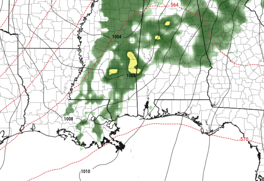
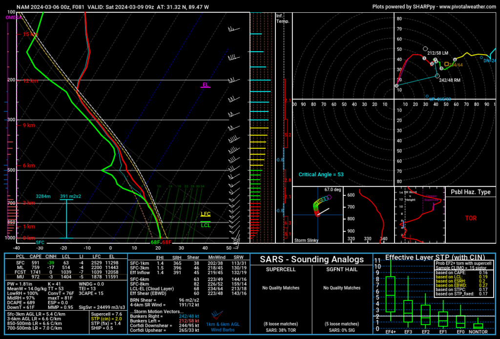
Looking at some of the higher resolution guidance (NAM model) above, it woudl suggest that the threat for severe weather is quite real. But the global models – which tend to handle ‘big picture’ stuff better – ilke the ECMWF isn’t as sold.
For now, given the split in the numbers across the model guidance, the Karrie Meter is sitting at a 3.95. But there is still a bit of uncertainty given the differences between the models. So this number is likely going to change a bit. And on top of that, the timeline for the peak risk for severe weather is still uncertain – some models suggest the afternoon others suggest overnight.
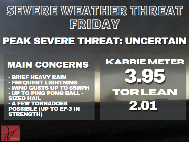
The good news is that the “TOR LEAN,” which is a formula I continue to experiment with, is lower than the Karie Meter which means the risk for tornadoes should be lower than a situation like this would normally suggest.
As we move into the weekend and early next week, high pressure will dominate our weather, bringing dry conditions. We will likely see a few colder morning next week, too. So far I dont think frost is in the forecast, but it is worth monitoring as many of the plants continue to think Spring has sprung.
REGIONAL DAY TO DAY FORECAST
Today: Partly sunny this morning, then clearing. Areas of fog this morning. Highs around 80. Northwest winds 5 to 10 mph.
Tonight: Mostly clear. Patchy fog after midnight. Lows in the mid 50s. North winds around 5 mph.
Thursday: Patchy fog in the morning. Mostly sunny. Highs around 80. East winds around 5 mph, becoming southeast around 5 mph in the afternoon.
Thursday Night: Mostly cloudy. Lows in the upper 50s. Southeast winds around 5 mph.
Friday: Mostly cloudy with storms possible. Some severe. Highs in the mid 70s. Southeast winds 15 to 20 mph with gusts up to 30 mph. Chance of rain 70 percent.
Friday Night: Cloudy with storms possible. Some severe. Near steady temperature in the mid 60s. Chance of rain near 100 percent.
Saturday: Mostly cloudy in the morning with a few showers. Then clearing skies in the afternoon. Highs in the mid 70s. Chance of rain 20 percent.
Saturday Night: Mostly cloudy. Much cooler with lows in the upper 40s.
Sunday: Partly sunny. Highs in the mid 60s.
Sunday Night: Mostly cloudy. Lows in the mid 40s.
Monday: Mostly sunny. Highs in the upper 60s.
Monday Night: Mostly clear in the evening, then becoming partly cloudy. Lows in the lower 40s.
Tuesday: Mostly sunny. Highs in the mid 70s.


Excellent, calm, evidence supported forecast accompanied by reasoned, thoughtful commentary. We miss you sorely in the Pine Belt. Your forecasts and explanations were occasionally in the technical weeds but we’re always informative and helpful! I continue to hope for local weather forecasting like yours rather than the apparent dollar-driven, hyped “Weather Alert Day” of the week.
Grrrrr, annoying autocorrect!
… were always informative…