the weather conditions across our area are stabilizing after some scattered showers and thunderstorms earlier this morning. However, we’re expecting another disturbance to move through later today, bringing more showers and thunderstorms, especially during the afternoon. There’s a slight chance that some of these storms could become severe, mainly in the western and southern parts of the area.
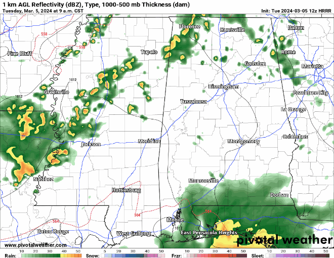
As the day progresses, temperatures will rise, making the atmosphere a bit more unstable, and the winds higher up in the atmosphere will support the development of some stronger storms. The main threats from these storms could be damaging winds, hail up to the size of quarters, and heavy rain, which might lead to localized flooding on roads and in low-lying areas.
By late afternoon, the disturbance will move out of our area, and the rain chances will decrease. Winds from the northwest will bring in some drier air tonight, and high pressure will build in, leading to quieter conditions with partly to mostly cloudy skies.
Looking ahead to the rest of the week, on Thursday into Thursday night, a trough to the west will bring warm, moist air to our region, increasing the risk of heavy rain and thunderstorms, which could lead to flash flooding.
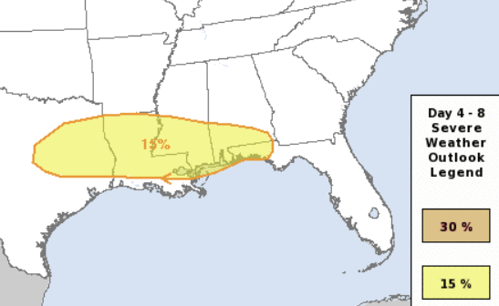
Friday morning, a warm front will lift northward, increasing the chances of severe thunderstorms, especially closer to the Gulf Coast. The details of how far north this severe weather threat extends are still uncertain, but all modes of severe weather, including damaging winds, hail, and tornadoes, will be possible.
After this system moves through, a cold front will pass, bringing cooler, drier air for the weekend. However, there’s a possibility of frost or light freeze conditions, especially considering the start of the local growing season, so we’ll need to monitor this closely.
REGIONAL DAY TO DAY FORECAST
Today: A slight chance of thunderstorms. Showers. Highs in the lower 70s. South winds 5 to 10 mph. Chance of rain 80 percent.
Tonight: Mostly cloudy. Patchy fog in the evening, then areas of fog after midnight. Lows in the upper 50s. West winds around 5 mph, becoming northwest after midnight.
Wednesday: Areas of fog in the morning. Mostly sunny. Highs around 80. Northwest winds around 5 mph.
Wednesday Night: Mostly clear in the evening, then becoming partly cloudy. Lows in the mid 50s. Northwest winds around 5 mph in the evening, becoming light and variable.
Thursday: Mostly sunny. Highs around 80. East winds 5 to 10 mph, becoming southeast in the afternoon.
Thursday Night: Mostly cloudy. A slight chance of showers after midnight. Lows in the upper 50s. Chance of rain 20 percent.
Friday: Mostly cloudy. A chance of showers in the morning, then showers with a chance of thunderstorms in the afternoon. Highs in the upper 70s. Chance of rain 60 percent.
Friday Night: Showers with a chance of thunderstorms. Near steady temperature in the mid 60s. Chance of rain 70 percent.
Saturday: Mostly cloudy. A chance of showers and thunderstorms, mainly in the morning. Highs in the lower 70s. Chance of rain 40 percent.
Saturday Night: Mostly cloudy. Cooler with lows in the upper 40s.
Sunday: Mostly sunny. Highs in the upper 60s.
Sunday Night: Mostly cloudy. Lows in the lower 40s.
Monday: Mostly sunny. Highs around 70.


