We’ve got a fair bit of fog out there this morning, particularly in the low-lying areas. ,It is a good indicator that humid air continues to invade the area As the day progresses, moisture levels will rise significantly, reaching well above normal. This increase in moisture, combined with some atmospheric disturbances, will lead to more showers and thunderstorms later in the evening.
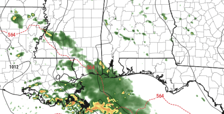
The HRRR model, shown below, shows a chance for some rain by about 10p tonight. But it also shows the heaviest of the rain offshore.
While we can’t rule out a few strong storms this afternoon, coverage should remain rather isolated.
For the rest of the week, we anticipate a continuation of unsettled weather patterns. While there will be brief breaks in the rain, overall, expect showers and storms to persist, especially later this week on Thursday and Friday.
There’s a growing concern for heavy rainfall and flash flooding, particularly late Thursday night. Additionally, we’ll be monitoring the potential for severe storms during this time. The CIPS Analogs are showing some reasonably good numbers for potential analogs for late this week.

But the difficulty is there is a bit of ‘boom or bust’ to the maps.
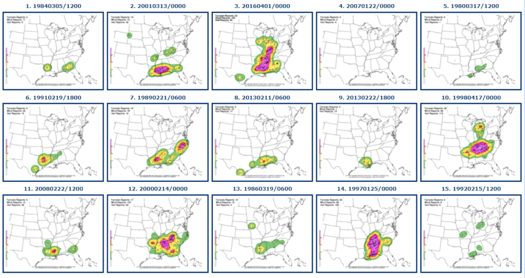
When you se things like this, it is a good reminder as to why I’m losing my hair. It isn’t so much that “bad weather will definitely happen” as much as it is “bad weather could happen, and if it is bad, it may be pretty rough. Or nothing may happen at all.”
and as a forecaster, that isn’t very helpful.
As we head into the weekend, rain will gradually clear out, with high pressure building in. This will bring drier and slightly cooler conditions for Saturday night through Sunday night.
REGIONAL DAY TO DAY FORECAST
Today: Mostly cloudy. Areas of dense fog this morning. A slight chance of showers and storms this afternoon and evening. Highs in the mid 70s. Southeast winds 10 to 15 mph. Chance of rain 40 percent.
Tonight: A chance of thunderstorms. Showers. Patchy fog after midnight. Lows in the lower 60s. Southeast winds 5 to 10 mph. Chance of rain 80 percent.
Tuesday: Patchy fog in the morning. A chance of thunderstorms. Showers. Highs in the lower 70s. South winds 5 to 10 mph. Chance of rain 90 percent.
Tuesday Night: Mostly cloudy. fog possible overnight. Lows in the upper 50s. West winds around 5 mph.
Wednesday: Areas of fog in the morning. Mostly sunny. Highs around 80. Northwest winds around 5 mph.
Wednesday Night: Partly cloudy. Lows in the mid 50s.
Thursday: Mostly sunny. Highs in the lower 80s.
Thursday Night: Mostly cloudy. A chance of showers with a slight chance of thunderstorms after midnight. Lows in the lower 60s. Chance of rain 30 percent.
Friday: Showers likely with a chance of thunderstorms in the morning, then showers with thunderstorms likely in the afternoon. Highs in the upper 70s. Chance of rain 90 percent.
Friday Night: Showers with thunderstorms likely in the evening, then showers likely with a chance of thunderstorms after midnight. Lows in the mid 60s. Chance of rain 80 percent.
Saturday: Mostly cloudy in the morning, then becoming partly sunny. A slight chance of thunderstorms in the morning. A chance of showers. Highs in the mid 70s. Chance of rain 40 percent.
Saturday Night: Mostly cloudy in the evening, then becoming partly cloudy. Much cooler with lows in the upper 40s.
Sunday: Mostly sunny. Highs in the upper 60s.


