As mentioned in yesterday’s post, another storm system will move through with the help of the subtropical jet stream. By Friday, we’ll see another front move in with a chance of heavy rain and possible severe weather.
Starting off tonight, another round of dense fog will settle over most of the southern parts of the Pinebelt along with areas along the coast and southern Louisiana. Temperatures will remain in the low 60s overnight and the fog will lift around 9am or so. A few scattered showers and thunderstorms will be possible across the Pinebelt in the afternoon with temperatures reaching the mid 70s.
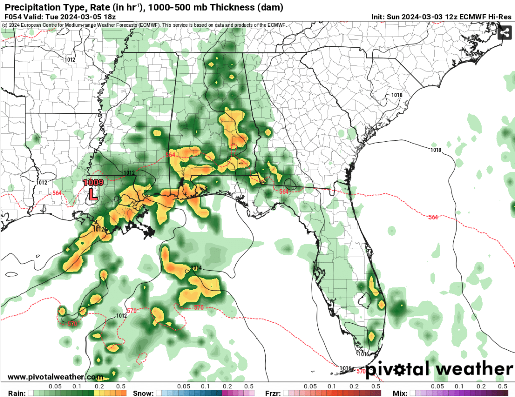
Overnight into Tuesday, some scattered thunderstorms will develop in the morning into the mid-afternoon. Due to an approaching cold front north of the Pinebelt, heavier storms will likely stay further west and south closer to the coast with the heaviest rain happening around there, but areas around the Pinebelt will also get a bit of the rain during the day.
Despite the cold front moving in after the rain’s over, we won’t see a drastic change in temperature like we saw last week. While we’ll have a brief dry day on Wednesday, temperatures will climb into the upper 70s and winds will eventually shift back to the southeast on Thursday. Thursday will introduce a warm front to the southeast as a low pressure system from the southern Rockies will begin to move east. This is part of a larger longwave front that will take precedence over the next storm system from Thursday night into Friday night.
//Courtesy: WPC

The storm system so far looks to be a heavy rain event (some areas getting up to 4 inches of rain over 24 hours!); however, depending on the cold front that follows the heavy rain from the warm front, there may be some other possible factors that could come into play. The wind shear up the atmospheric column could indicate some strong winds and possibly even a tornado, and a slight dry column in the middle atmosphere could indicate possible hail development. For now, we’ll have to wait for models to update to see what all will be possible going into Friday night.
Saturday may be on the soggy side with the front still moving through with the rain. We’ll reach the low 70s during the day and clouds moving out. By Sunday, we’ll feel more early spring-like with northwest winds blowing and temperatures in the mid 60s.
Have a good week!
[wpcode id=”41179″]
Regional Day-to-Day Forecast
Tonight – Patchy dense fog after midnight. Otherwise, mostly cloudy, with a low in the low 60s. Southeast wind around 5 mph.
Monday – A 30 percent chance of showers and thunderstorms, mainly in the mid-afternoon to evening. Areas of dense fog before 9am. Otherwise, mostly cloudy, with a high in the mid 70s. Southeast wind 5 to 10 mph.
Monday Night – Showers and thunderstorms likely, mainly after midnight. Cloudy, with a low in the low 60s. Southeast wind 5 to 10 mph. Chance of precipitation is 70%. New rainfall amounts between a quarter and half of an inch possible.
Tuesday – Showers and thunderstorms. High in the low 70s. East wind 5 to 10 mph, with gusts as high as 20 mph. Chance of precipitation is 80%. New rainfall amounts between 1 and 2 inches possible.
Tuesday Night – Mostly cloudy, with a low in the upper 50s. South southeast wind around 5 mph becoming calm after midnight.
Wednesday – Partly sunny, with a high in the upper 70s. North northwest wind 5 to 10 mph.
Wednesday Night – Partly cloudy, with a low in the mid 50s. North wind around 5 mph becoming east after midnight.
Thursday – A 20 percent chance of showers after noon. Partly sunny, with a high near 80. South southeast wind around 5 mph.
Thursday Night – A chance of rain and thunderstorms overnight. Mostly cloudy, with a low around 60. South southeast wind 5 to 10 mph, with gusts as high as 20 mph. Chance of precipitation is 50%.
Friday – Showers likely and possibly a thunderstorm, then showers and thunderstorms after noon. High in the mid 70s. Chance of precipitation is 90%.
Friday Night – Showers and thunderstorms likely. Cloudy, with a low around 59. Chance of precipitation is 70%.
Saturday – A 30 percent chance of rain and thunderstorms. Partly sunny, with a high in the low 70s.
Saturday Night – Partly cloudy, with a low in the mid 40s.
Sunday – Sunny, with a high in the mid 60s.
[wpcode id=”41149″]


