The Storm Prediction Center has maintained the Slight-to-Enhanced Risk for severe weather across the area, with some minor movements.

After most of the model guidance decided to get onboard with a reasonably similar outcome last night, this morning they have diverged again.
The question is: How early, ahead of the cold front, storms develop? Last night, a majority of the guidance showed a cluster of storms developing across Louisiana and Mississippi ahead of the front that looked to congeal and dump a fair bit of rain across the region.
This morning? A few of the models have pulled back on that potential. Leaving just the line of storms to plow through between about 9p and 4a tonight. Two notable models showing different outcomes are the NAM and the HRRR model.

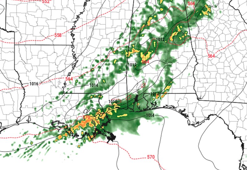
So which one is right? Many of you already know my favorite answer to this question — Neither one is right!
It will likely be a blend of the two. I find it unlikely we remain completely dry ahead of the line, but the coverage of storms may be a bit lighter. There is also some data to suggest that the storms may fire up farther southwest into Louisiana and dive into the Gulf sooner. That would be a “win” for everyone. It would end up acting as a “blob” out there to suck up all the warm Gulf moisture.
In the meantime, I have trimmed the forecast a bit for some and widened it out for others.
During the highlighted times below, expect to deal with…
EVERYONE — Brief heavy rain, lightning, and wind gusts up to 30mph
MOST PLACES — Brief heavy rain, lightning, and wind gusts up to 40mph
MANY SPOTS — Heavy rain, brief flash flooding, lightning, wind gusts up to 45mph
SOME PEOPLE — Heavy rain, brief localized flooding, wind gusts up to 55mph, small hail
FEW PLACES — Heavy rain, localized flooding, wind gusts exceeding 65mph, small hail, a brief tornado
County-by-County Timeline
A quick reminder that this timeline doesn’t mean that the entire time it will be raining and storming. It is an attempt to give you the best window of opportunity for storms to be near you. A three to four hour window may only feature rain and storms for 30-45 minutes. But the goal is to highlight a window where the threat is higher than at other times.
Louisiana
St. Helena Parish
Wednesday 2p-6p — Breezy. Isolated showers with few rumbles of thunder developing early, very few (if any) storms may be strong to severe before 4p. Main threats with any storm will be heavy rain, frequent lightning, gusty wind, small hail, and a tornado can not be ruled out.
Wednesday 6p-12a — Showers and storms likely, many strong with a handful severe. Main threats with stronger storms will be very heavy rain, frequent lightning, wind gusts up to 60mph, hail up to the size of quarters, and the potential for a tornado.
Thursday 12a-6a — Storms ending. Turning cooler and breezy.
Tangipahoa Parish
Wednesday 2p-6p — Breezy. Isolated showers with few rumbles of thunder developing early, very few (if any) storms may be strong to severe before 4p. Main threats with any storm will be heavy rain, frequent lightning, gusty wind, small hail, and a tornado can not be ruled out.
Wednesday 6p-12a — Showers and storms likely, many strong with a handful severe. Main threats with stronger storms will be very heavy rain, frequent lightning, wind gusts up to 60mph, hail up to the size of quarters, and the potential for a tornado .
Thursday 12a-6a — Storms ending. Turning cooler and breezy.
Livingston Parish
Wednesday 2p-6p — Breezy. Isolated showers with few rumbles of thunder developing early, very few (if any) storms may be strong to severe before 4p. Main threats with any storm will be heavy rain, frequent lightning, gusty wind, small hail, and a tornado can not be ruled out.
Wednesday 6p-12a — Showers and storms likely, many strong with a handful severe. Main threats with stronger storms will be very heavy rain, frequent lightning, wind gusts up to 60mph, hail up to the size of quarters, and the potential for a tornado.
Thursday 12a-6a — Storms ending. Turning cooler and breezy.
Washington Parish
Wednesday 3p-7p — Breezy. Isolated showers with few rumbles of thunder developing early, very few (if any) storms may be strong to severe before 6p. Main threats with any storm will be heavy rain, frequent lightning, gusty wind, small hail, and a tornado can not be ruled out.
Wednesday 7p-1a — Showers and storms likely, many strong with a handful severe. Main threats with stronger storms will be very heavy rain, frequent lightning, wind gusts up to 60mph, hail up to the size of quarters, and the potential for a tornado.
Thursday 1a-7a — Storms ending. Turning cooler and breezy.
St. Tammany Parish
Wednesday 3p-7p — Breezy. Isolated showers with few rumbles of thunder developing early, very few (if any) storms may be strong to severe before 6p. Main threats with any storm will be heavy rain, frequent lightning, gusty wind, small hail, and a tornado can not be ruled out.
Wednesday 7p-1a — Showers and storms likely, many strong with a handful severe. Main threats with stronger storms will be very heavy rain, frequent lightning, wind gusts up to 60mph, hail up to the size of quarters, and the potential for a tornado.
Thursday 1a-7a — Storms ending. Turning cooler and breezy.
Mississippi
NEAR I-20
Copiah County
Wednesday 4p-7p — Breezy. Isolated showers with few rumbles of thunder developing early, very few (if any) storms may be strong to severe before 6p. Main threats with any storm will be heavy rain, frequent lightning, gusty wind, small hail, and a tornado can not be ruled out.
Wednesday 7p-12a — Showers and storms likely, many strong with a handful severe. Main threats with stronger storms will be very heavy rain, frequent lightning, wind gusts up to 60mph, hail up to the size of quarters, and the potential for a tornado.
Thursday 1a-7a — Storms ending. Turning cooler and breezy.
Simpson County
Wednesday 4p-7p — Breezy. Isolated showers with few rumbles of thunder developing early, very few (if any) storms may be strong to severe before 6p. Main threats with any storm will be heavy rain, frequent lightning, gusty wind, small hail, and a tornado can not be ruled out.
Wednesday 7p-12a — Showers and storms likely, many strong with a handful severe. Main threats with stronger storms will be very heavy rain, frequent lightning, wind gusts up to 60mph, hail up to the size of quarters, and the potential for a tornado.
Thursday 1a-7a — Storms ending. Turning cooler and breezy.
Smith County
Wednesday 4p-7p — Breezy. Isolated showers with few rumbles of thunder developing early, very few (if any) storms may be strong to severe before 6p. Main threats with any storm will be heavy rain, frequent lightning, gusty wind, small hail, and a tornado can not be ruled out.
Wednesday 7p-12a — Showers and storms likely, many strong with a handful severe. Main threats with stronger storms will be very heavy rain, frequent lightning, wind gusts up to 60mph, hail up to the size of quarters, and the potential for a tornado.
Thursday 1a-7a — Storms ending. Turning cooler and breezy.
Jasper County
Wednesday 5p-8p — Breezy. Isolated showers with few rumbles of thunder developing early, very few (if any) storms may be strong to severe before 6p. Main threats with any storm will be heavy rain, frequent lightning, gusty wind, small hail, and a tornado can not be ruled out.
Wednesday 8p-2a — Showers and storms likely, many strong with a handful severe. Main threats with stronger storms will be very heavy rain, frequent lightning, wind gusts up to 60mph, hail up to the size of quarters, and the potential for a tornado.
Thursday 2a-8a — Storms ending. Turning cooler and breezy.
Clarke County
Wednesday 6p-9a — Breezy. Isolated showers with few rumbles of thunder developing early, very few (if any) storms may be strong to severe before 9p. Main threats with any storm will be heavy rain, frequent lightning, gusty wind, small hail, and a tornado can not be ruled out.
Wednesday 9a-3a — Showers and storms likely, many strong with a handful severe. Main threats with stronger storms will be very heavy rain, frequent lightning, wind gusts up to 60mph, hail up to the size of quarters, and the potential for a tornado.
Thursday 3a-9a — Storms ending. Turning cooler and breezy.
HIGHWAY 84 CORRIDOR
Lincoln County
Wednesday 4p-7p — Breezy. Isolated showers with few rumbles of thunder developing early, very few (if any) storms may be strong to severe before 6p. Main threats with any storm will be heavy rain, frequent lightning, gusty wind, small hail, and a tornado can not be ruled out.
Wednesday 7p-12a — Showers and storms likely, many strong with a handful severe. Main threats with stronger storms will be very heavy rain, frequent lightning, wind gusts up to 60mph, hail up to the size of quarters, and the potential for a tornado.
Thursday 1a-7a — Storms ending. Turning cooler and breezy.
Lawrence County
Wednesday 4p-7p — Breezy. Isolated showers with few rumbles of thunder developing early, very few (if any) storms may be strong to severe before 6p. Main threats with any storm will be heavy rain, frequent lightning, gusty wind, small hail, and a tornado can not be ruled out.
Wednesday 7p-12a — Showers and storms likely, many strong with a handful severe. Main threats with stronger storms will be very heavy rain, frequent lightning, wind gusts up to 60mph, hail up to the size of quarters, and the potential for a tornado.
Thursday 1a-7a — Storms ending. Turning cooler and breezy.
Jeff Davis County
Wednesday 4p-7p — Breezy. Isolated showers with few rumbles of thunder developing early, very few (if any) storms may be strong to severe before 7p. Main threats with any storm will be heavy rain, frequent lightning, gusty wind, small hail, and a tornado can not be ruled out.
Wednesday 7p-1a — Showers and storms likely, many strong with a handful severe. Main threats with stronger storms will be very heavy rain, frequent lightning, wind gusts up to 60mph, hail up to the size of quarters, and the potential for a tornado.
Thursday 1a-7a — Storms ending. Turning cooler and breezy.
Covington County
Wednesday 5p-8p — Breezy. Isolated showers with few rumbles of thunder developing early, very few (if any) storms may be strong to severe before 7p. Main threats with any storm will be heavy rain, frequent lightning, gusty wind, small hail, and a tornado can not be ruled out.
Wednesday 8p-2a — Showers and storms likely, many strong with a handful severe. Main threats with stronger storms will be very heavy rain, frequent lightning, wind gusts up to 60mph, hail up to the size of quarters, and the potential for a tornado.
Thursday 2a-8a — Storms ending. Turning cooler and breezy.
Jones County
Wednesday 5p-8p — Breezy. Isolated showers with few rumbles of thunder developing early, very few (if any) storms may be strong to severe before 7p. Main threats with any storm will be heavy rain, frequent lightning, gusty wind, small hail, and a tornado can not be ruled out.
Wednesday 8p-2a — Showers and storms likely, many strong with a handful severe. Main threats with stronger storms will be very heavy rain, frequent lightning, wind gusts up to 60mph, hail up to the size of quarters, and the potential for a tornado.
Thursday 2a-8a — Storms ending. Turning cooler and breezy.
Wayne County
Wednesday 6p-9a — Breezy. Isolated showers with few rumbles of thunder developing early, very few (if any) storms may be strong to severe before 9p. Main threats with any storm will be heavy rain, frequent lightning, gusty wind, small hail, and a tornado can not be ruled out.
Wednesday 9a-3a — Showers and storms likely, many strong with a handful severe. Main threats with stronger storms will be very heavy rain, frequent lightning, wind gusts up to 60mph, hail up to the size of quarters, and the potential for a tornado.
Thursday 3a-9a — Storms ending. Turning cooler and breezy.
HIGHWAY 98 CORRIDOR
Pike County
Wednesday 3p-7p — Breezy. Isolated showers with few rumbles of thunder developing early, very few (if any) storms may be strong to severe before 6p. Main threats with any storm will be heavy rain, frequent lightning, gusty wind, small hail, and a tornado can not be ruled out.
Wednesday 7p-1a — Showers and storms likely, many strong with a handful severe. Main threats with stronger storms will be very heavy rain, frequent lightning, wind gusts up to 60mph, hail up to the size of quarters, and the potential for a tornado.
Thursday 1a-7a — Storms ending. Turning cooler and breezy.
Walthall County
Wednesday 3p-7p — Breezy. Isolated showers with few rumbles of thunder developing early, very few (if any) storms may be strong to severe before 6p. Main threats with any storm will be heavy rain, frequent lightning, gusty wind, small hail, and a tornado can not be ruled out.
Wednesday 7p-1a — Showers and storms likely, many strong with a handful severe. Main threats with stronger storms will be very heavy rain, frequent lightning, wind gusts up to 60mph, hail up to the size of quarters, and the potential for a tornado.
Thursday 1a-7a — Storms ending. Turning cooler and breezy.
Marion County
Wednesday 4p-8p — Breezy. Isolated showers with few rumbles of thunder developing early, very few (if any) storms may be strong to severe before 7p. Main threats with any storm will be heavy rain, frequent lightning, gusty wind, small hail, and a tornado can not be ruled out.
Wednesday 8p-2a — Showers and storms likely, many strong with a handful severe. Main threats with stronger storms will be very heavy rain, frequent lightning, wind gusts up to 60mph, hail up to the size of quarters, and the potential for a tornado.
Thursday 2a-8a — Storms ending. Turning cooler and breezy.
Lamar County
Wednesday 5p-8p — Breezy. Isolated showers with few rumbles of thunder developing early, very few (if any) storms may be strong to severe before 7p. Main threats with any storm will be heavy rain, frequent lightning, gusty wind, small hail, and a tornado can not be ruled out.
Wednesday 8p-2a — Showers and storms likely, many strong with a handful severe. Main threats with stronger storms will be very heavy rain, frequent lightning, wind gusts up to 60mph, hail up to the size of quarters, and the potential for a tornado.
Thursday 2a-8a — Storms ending. Turning cooler and breezy.
Forrest County
Wednesday 5p-8p — Breezy. Isolated showers with few rumbles of thunder developing early, very few (if any) storms may be strong to severe before 7p. Main threats with any storm will be heavy rain, frequent lightning, gusty wind, small hail, and a tornado can not be ruled out.
Wednesday 8p-2a — Showers and storms likely, many strong with a handful severe. Main threats with stronger storms will be very heavy rain, frequent lightning, wind gusts up to 60mph, hail up to the size of quarters, and the potential for a tornado.
Thursday 2a-8a — Storms ending. Turning cooler and breezy.
Perry County
Wednesday 7p-1a — Breezy. Isolated showers with few rumbles of thunder developing early, very few (if any) storms may be strong to severe before 9p. Main threats with any storm will be heavy rain, frequent lightning, gusty wind, small hail, and a tornado can not be ruled out.
Wednesday 1a-4a — Showers and storms likely, many strong with a handful severe. Main threats with stronger storms will be very heavy rain, frequent lightning, wind gusts up to 60mph, hail up to the size of quarters, and the potential for a tornado.
Thursday 4a-10a — Storms ending. Turning cooler and breezy.
Greene County
Wednesday 7p-1a — Breezy. Isolated showers with few rumbles of thunder developing early, very few (if any) storms may be strong to severe before 9p. Main threats with any storm will be heavy rain, frequent lightning, gusty wind, small hail, and a tornado can not be ruled out.
Wednesday 1a-4a — Showers and storms likely, many strong with a handful severe. Main threats with stronger storms will be very heavy rain, frequent lightning, wind gusts up to 60mph, hail up to the size of quarters, and the potential for a tornado.
Thursday 4a-10a — Storms ending. Turning cooler and breezy.
HIGHWAY 26 CORRIDOR
Pearl River County
Wednesday 3p-7p — Breezy. Isolated showers with few rumbles of thunder developing early, very few (if any) storms may be strong to severe before 6p. Main threats with any storm will be heavy rain, frequent lightning, gusty wind, small hail, and a tornado can not be ruled out.
Wednesday 7p-1a — Showers and storms likely, many strong with a handful severe. Main threats with stronger storms will be very heavy rain, frequent lightning, wind gusts up to 60mph, hail up to the size of quarters, and the potential for a tornado.
Thursday 1a-7a — Storms ending. Turning cooler and breezy.
Stone County
Wednesday 4p-8p — Breezy. Isolated showers with few rumbles of thunder developing early, very few (if any) storms may be strong to severe before 8p. Main threats with any storm will be heavy rain, frequent lightning, gusty wind, small hail, and a tornado can not be ruled out.
Wednesday 8p-2a — Showers and storms likely, many strong with a handful severe. Main threats with stronger storms will be very heavy rain, frequent lightning, wind gusts up to 60mph, hail up to the size of quarters, and the potential for a tornado.
Thursday 2a-8a — Storms ending. Turning cooler and breezy.
George County
Wednesday 5p-1a — Breezy. Isolated showers with few rumbles of thunder developing early, very few (if any) storms may be strong to severe before 9p. Main threats with any storm will be heavy rain, frequent lightning, gusty wind, small hail, and a tornado can not be ruled out.
Wednesday 1a-5a — Showers and storms likely, many strong with a handful severe. Main threats with stronger storms will be very heavy rain, frequent lightning, wind gusts up to 60mph, hail up to the size of quarters, and the potential for a tornado.
Thursday 5a-11a — Storms ending. Turning cooler and breezy.
COASTAL MISSISSIPPI
Jackson County
Wednesday 3p-1a — Breezy. Isolated showers with few rumbles of thunder developing early, very few (if any) storms may be strong to severe before 9p. Main threats with any storm will be heavy rain, frequent lightning, gusty wind, small hail, and a tornado can not be ruled out.
Thursday 1a-5a — Showers and storms likely, many strong with a handful severe. Main threats with stronger storms will be very heavy rain, frequent lightning, wind gusts up to 60mph, hail up to the size of quarters, and the potential for a tornado.
Thursday 5a-11a — Storms ending. Turning cooler and breezy.
Harrison County
Wednesday 3p-1a — Breezy. Isolated showers with few rumbles of thunder developing early, very few (if any) storms may be strong to severe before 9p. Main threats with any storm will be heavy rain, frequent lightning, gusty wind, small hail, and a tornado can not be ruled out.
Thursday 1a-5a — Showers and storms likely, many strong with a handful severe. Main threats with stronger storms will be very heavy rain, frequent lightning, wind gusts up to 60mph, hail up to the size of quarters, and the potential for a tornado.
Thursday 5a-11a — Storms ending. Turning cooler and breezy.
Hancock County
Wednesday 3p-1a — Breezy. Isolated showers with few rumbles of thunder developing early, very few (if any) storms may be strong to severe before 9p. Main threats with any storm will be heavy rain, frequent lightning, gusty wind, small hail, and a tornado can not be ruled out.
Thursday 1a-5a — Showers and storms likely, many strong with a handful severe. Main threats with stronger storms will be very heavy rain, frequent lightning, wind gusts up to 60mph, hail up to the size of quarters, and the potential for a tornado.
Thursday 5a-11a — Storms ending. Turning cooler and breezy.
Alabama
Sumter County
Wednesday 7p-1a — Breezy. Isolated showers with few rumbles of thunder developing early, very few (if any) storms may be strong to severe before 9p. Main threats with any storm will be heavy rain, frequent lightning, gusty wind, small hail, and a tornado can not be ruled out.
Wednesday 1a-5a — Showers and storms likely, many strong with a handful severe. Main threats with stronger storms will be very heavy rain, frequent lightning, wind gusts up to 60mph, hail up to the size of quarters, and the potential for a tornado.
Thursday 5a-11a — Storms ending. Turning cooler and breezy.
Choctaw County
Wednesday 7p-1a — Breezy. Isolated showers with few rumbles of thunder developing early, very few (if any) storms may be strong to severe before 9p. Main threats with any storm will be heavy rain, frequent lightning, gusty wind, small hail, and a tornado can not be ruled out.
Wednesday 1a-5a — Showers and storms likely, many strong with a handful severe. Main threats with stronger storms will be very heavy rain, frequent lightning, wind gusts up to 60mph, hail up to the size of quarters, and the potential for a tornado.
Thursday 5a-11a — Storms ending. Turning cooler and breezy.
Washington County
Wednesday 7p-1a — Breezy. Isolated showers with few rumbles of thunder developing early, very few (if any) storms may be strong to severe before 9p. Main threats with any storm will be heavy rain, frequent lightning, gusty wind, small hail, and a tornado can not be ruled out.
Wednesday 1a-5a — Showers and storms likely, many strong with a handful severe. Main threats with stronger storms will be very heavy rain, frequent lightning, wind gusts up to 60mph, hail up to the size of quarters, and the potential for a tornado.
Thursday 5a-11a — Storms ending. Turning cooler and breezy.


