While there were some scattered storms across the region today, most locations west of I65 will be baking over the few days.
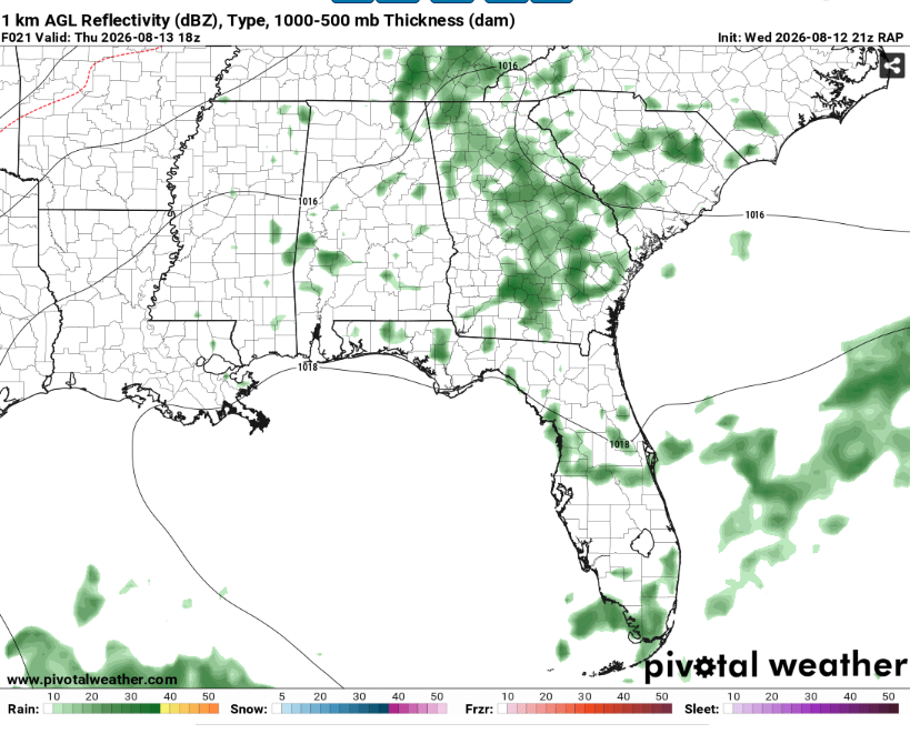
This plot from the RAP is probably over done but the gist of the story is that storms will be most likely further east. They probably won’t be severe but could still cause some heavy rain and frequent lightning (and maybe some strong downbursts as they collapse). Most locations will remain dry though as large scale ascent will be weak.
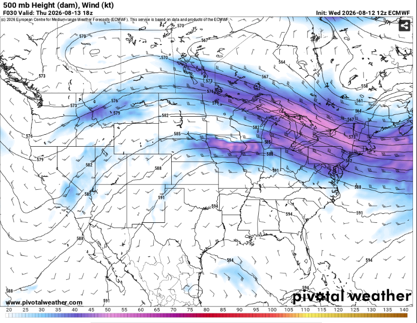
This is due to the position of the ridge which has shifted from being over the desert Southwest to parking itself right over us. These setups are often the ones that bring us the most intense heat waves and this one is no exception.
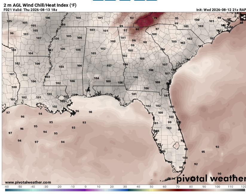
Heat indexes will likely exceed 105 area wide given highs in the upper 90s and mid 70s dew points. Take frequent breaks in the AC and drink plenty of fluids if you must be outside. This will be a good stretch of days to get work done inside or go to the pool.
The pattern looks to remain this way for at least another 10 days as the ridge builds in overhead. Given repeated days of extreme heat and minimal chances for widespread rainfall, concerns for heat related impacts will only increase. Lows will likely only fall to the mid to upper 70s allowing for little relief when considering the high relative humidity.
Airport Forecasts
Houston (KIAH/KHOU)- Afternoon thunderstorms possible each of the next few days. These storms should be fairly short lived but may cause a delay or two for lightning or microbursts.
Shreveport (KSHV)- Very hot and humid but no storms are anticipated.
Baton Rouge (KBTR)- Very unpleasant heat and humidity but nothing that should delay flights.
New Orleans (KMSY)- Warm and humid but no issues for flying.
Jackson (KJAN)- Another location with very hot and humid weather but no storms or problems are expected.
Mobile (KMOB)- It’ll feel like a sauna but flights look all clear.
Birmingham (KBMH)- Afternoon and evening thunderstorms possible each of the next couple days. These storms should be weak and short lived but may still cause a delay or two for lightning or downbursts.
Tallahassee (KTLH)- Afternoon and evening thunderstorms possible each of the next few days. They probably won’t be severe but they may be capable of some delays for lightning or downdrafts.
Atlanta (KATL)- Mostly fine. There’s a low chance of afternoon thunderstorms tomorrow afternoon which cause delays for lightning or microbursts.
Highways
I-10 – Isolated storms possible in Florida the next two afternoons. The vast majority of locations will be dry but you may encounter five minutes of very heavy rain.
I-20 – Can’t rule out a storm or two across eastern Alabama into Georgia during the next two afternoons but these will be very isolated.
I-49 – No issues expected.
I-55 and I-59 – Very hot and humid but driving should be chill.
I-65 – Maaaaaybe a storm or two in Alabama during the next two afternoons but 99% of places and times will be dry.
I-75 – Widely scattered storms possible the next two days across Georgia. They won’t be anything crazy but be mindful of water on roadways.
City Forecasts
Houston, TX
Tonight- Mostly clear with a low around 80. No rain.
Tomorrow- Mostly sunny with a high in the mid 90s. Isolated afternoon thunderstorms possible. South winds around 10 mph.
Friday- Mostly sunny with a high in the mid 90s. Widely scattered afternoon thunderstorms possible. South winds around 10 mph.
Shreveport, LA
Tonight- Mostly clear with a low in the upper 70s. Light south breeze and no rain.
Tomorrow- Mostly sunny with a high around 100. Dry. Heat advisory valid through 8/16 at 8pm.
Friday- Mostly sunny with a high in the upper 90s. No precip expected.
Baton Rouge, LA
Tonight- Mostly clear with a low in the upper 70s. No rain.
Tomorrow- Mostly sunny with a high in the upper 90s. Dry but humid with a heat advisory in place for the afternoon.
Friday- Mostly sunny with a high in the upper 90s. No precip expected.
New Orleans, LA
Tonight- Mostly clear with a low in the upper 70s. Dry but humid.
Tomorrow- Mostly sunny with a high in the mid 90s. No rain with a heat advisory in place for the afternoon.
Friday- Mostly sunny with a high in the mid 90s. No precip expected.
Jackson, MS
Tonight- Mostly clear with a low in the upper 70s. No rain.
Tomorrow- Mostly sunny with a high in the upper 90s. Dry but humid with a heat advisory valid through 7pm on Friday.
Friday- Mostly sunny with a high in the low 100s. No precip expected.
Birmingham, AL
Tonight- Isolated thunderstorms possible before midnight. Partly cloudy with a low in the mid 70s.
Tomorrow- Mostly sunny with a high in the mid 90s. Heat advisory valid through Friday evening with isolated afternoon thunderstorms possible.
Friday- Mostly sunny with a high in the mid 90s. Isolated afternoon thunderstorms possible.
Mobile, AL
Tonight- Clear with a low in the upper 70s. No rain.
Tomorrow- Mostly sunny with a high in the mid 90s. Dry but humid with a heat advisory in the afternoon.
Friday- Mostly sunny with a high in the upper 90s. No precip expected.
Tallahassee, FL
Tonight- Storms clear out by midnight. Decreasing clouds with a low in the upper 70s.
Tomorrow- Increasing clouds with scattered afternoon thunderstorms possible. High in the mid 90s with a heat advisory valid for the afternoon.
Friday- Scattered afternoon thunderstorms likely. Increasing clouds with a high in the mid 90s.
Atlanta, GA
Tonight- Mostly clear with a low in the mid 70s. No rain.
Tomorrow- Mostly sunny with a high in the low 90s. Isolated afternoon thunderstorms possible.
Friday- Mostly sunny with a high in the mid 90s. Humid but dry.


