The National Hurricane Center again skipped the Depression stage and turned Invest 97L directly into Tropical Storm Matthew.
 Just like last time, this isn’t terribly uncommon. Or terribly common. It just is.
So, now that we have Matthew, why should you care? What is in a name, right? Shakespeare was a smart guy, wasn’t he?
In this case, a name does mean something. It means the National Hurricane Center though the storm was organized and strong enough to have winds in excess of 40mph. As well as a localized area of closed low pressure.
It most certainly has both.
Who cares, dude?
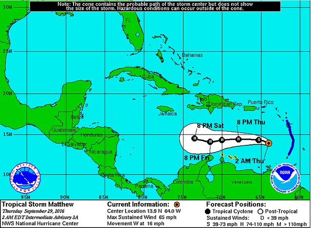
People in Jamaica, Cuba, the Bahamas, and the East Coast of the United States should care. Even the Gulf Coast states should be watching this, too.
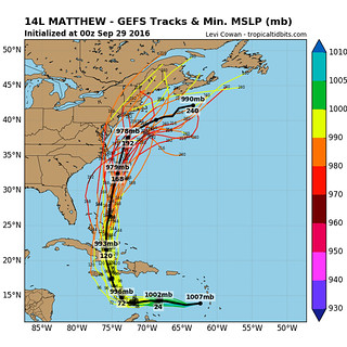
The Ensemble models have continue to push the storm farther west before kicking it back north, but that trend may change. That means a lot of folks needs to keep an eye on the forecast.
No need to go buy supplies or board up windows. Just check in with your local meteorologist on TV.
Matthew is expected to strengthen in the coming days. In the next 12 to 18 hours it will likely be a Category 1 Hurricane – with winds at about 75mph. Another 24 hours after that it could be as strong as a Category 2 Hurricane. That would mean winds around 95mph.
Beyond that, the thought is that it may continue to strengthen. And anyone in the path of this storm will likely have to deal with a Hurricane – be it Cat 1, 2 or perhaps even 3.
But 48 hours out is about as far as this meteorologist feels comfortable giving a forecast on intensity. The National Hurricane Center does a pretty good job out to 72 hours. Sometimes further, but sadly, the science is only so good right now, and we can’t have all of the answers.
More on that below.
You just listed off a ton of places, how big is this thing going to get?
Not THAT big. But the track is still uncertain.
The prevailing thought between the models and the smart folks at the National Hurricane Center is that Matthew will move tot he west, into the central Caribbean, and then make a turn to the north.
The question is, how far west does it make it before it makes the turn? And when it turns, how sharp is the turn?
Right now, we don’t know.
What we do know is that during the next 48 to 72 hours, it will continue on a generally westerly track and move into the central Caribbean.
And it will continue to strengthen, too.
How Strong will it be when it hits my house?
Depends on where you live. Are you on a boat in the middle of the Caribbean? Probably a weak Category 1 Hurricane. Are you in Jamaica? Maybe a Category 2 Hurricane. Live in the Bahamas? We’ll see, but I would start making preparations now for, at least, a Category 1 Hurricane.
A lot of folks in Florida, the Carolinas and all the way north to Massachusetts, could be dealing with anywhere from a strong Tropical Storm to a Category 3 Hurricane. Sadly, that far out, we just don’t know.
Okay, but what do you think will happen?
It would be irresponsible of me to venture a guess, because it wouldn’t be terribly accurate.
Honestly, folks, anyone can throw something out and say it will happen. We have powerful computer models that try their best to figure out what will happen. But they are far from perfect.
Because of that, I don’t want to tall anyone what I “think will happen” until I have enough evidence and scientific justification to do so. No sense in alerting the wrong group of people – or too many people – to something only to have the storm move slightly. I’m in the business of sound decision-making and accurate forecasting, no fear-mongering and guessing.
Again, speaking honestly, that is the difference between a real meteorologist and a the ones that say they are on social media. Understanding the limitations of the science and the technology is super important.
Alright, alright, we will stop bugging you… But when will you know about the Gulf or Florida?
We will have a better idea as we head into the weekend. Once this storm starts to make the turn to the north that is really when we will start to get a better handle on where this is going and what it may look like when it gets there.


