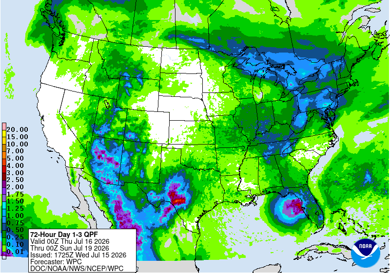
Over the three days, Texas, specifically the southern portion, will receive several inches of rain.
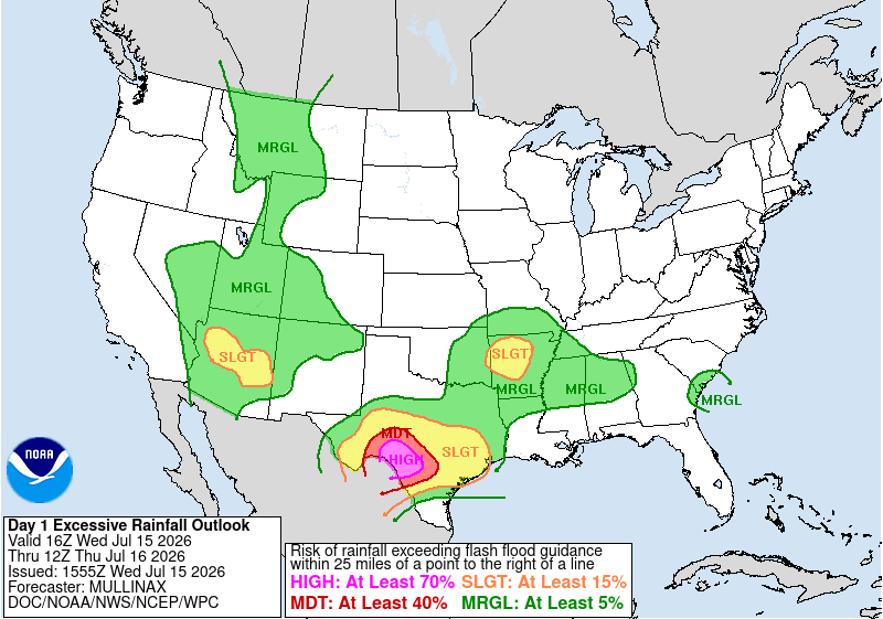
According to WPC, 80% of flood-related damage and 1/3 of all flood-related fatalities occur on high-risk days. This is a reminder to pay closer attention to NWS flood warnings on days like today.
The areas could see close to 7 inches or more of rain. Make sure we are staying weather aware.
Tonight
Southern Texas will continue to pile on rain throughout the rest of today. Scattered showers and thunderstorms will stretch from Northern MS to Southern FL until the nighttime hours (around 11 pm). Heavier rainfall is focused in Northern MS, Central AL, and Eastern FL. Isolated storms in Southern LA during the evening.
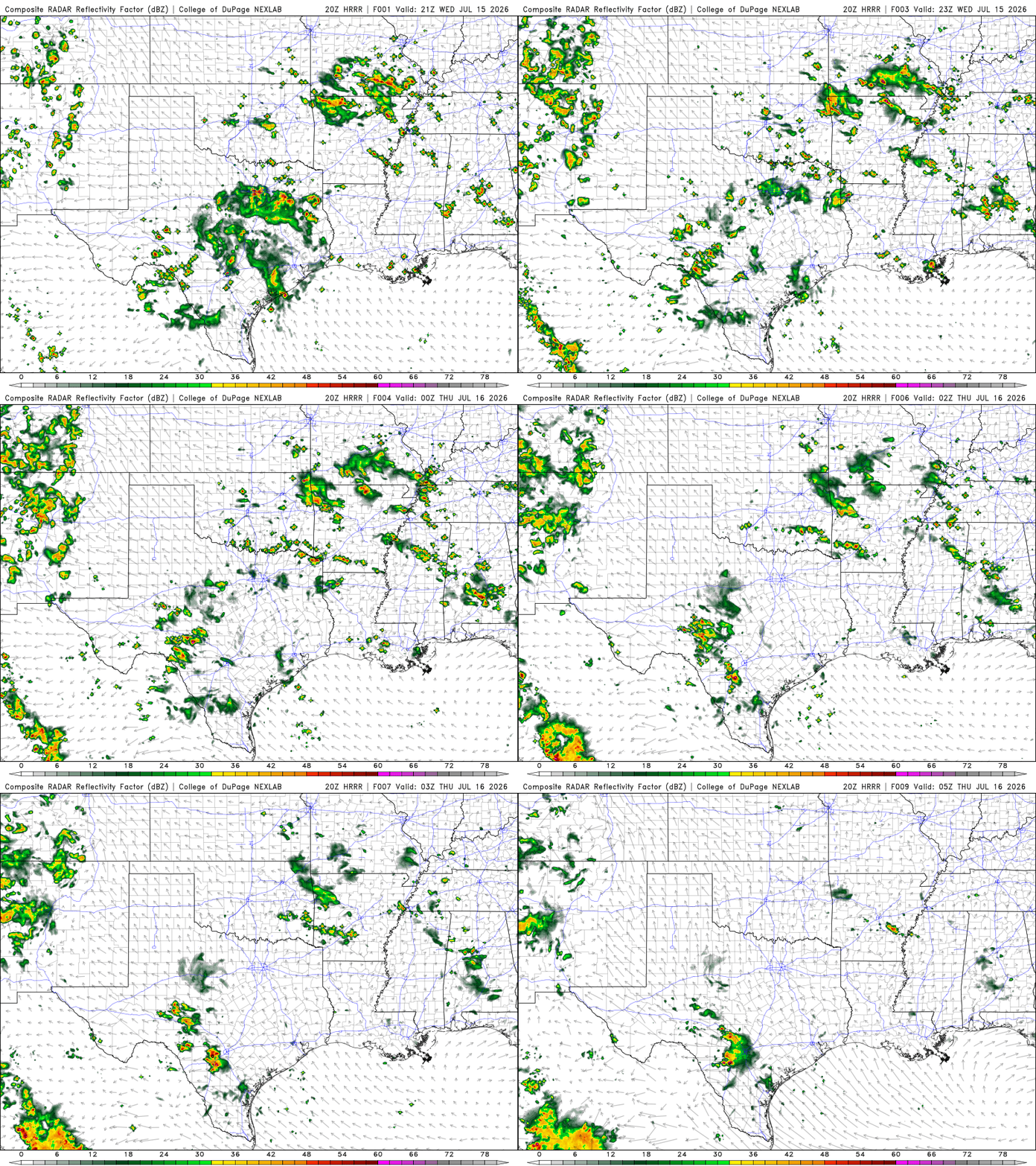
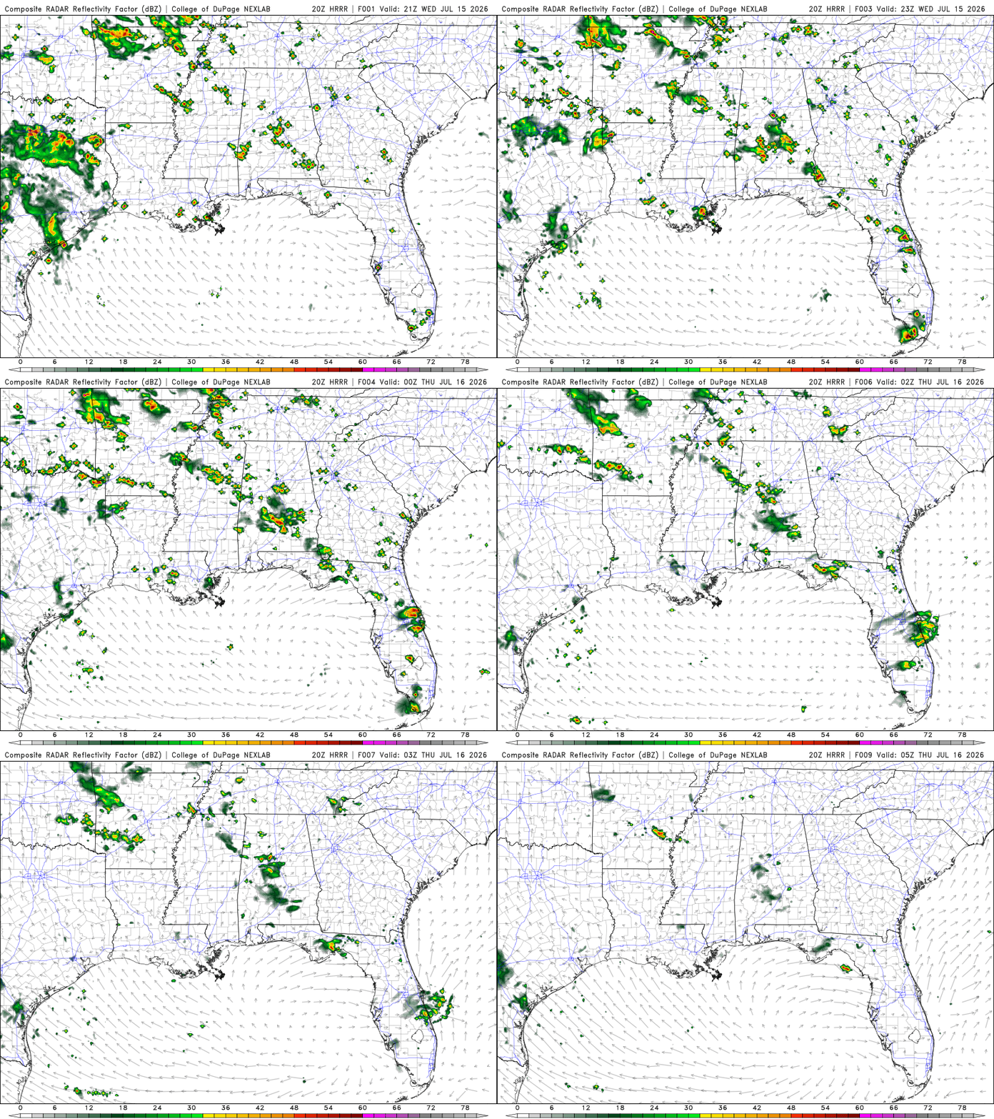
Marginal risk of excessive rainfall for Northern LA, MS, and AL. Isolated flash flooding possible.
Extended Regional Outlook
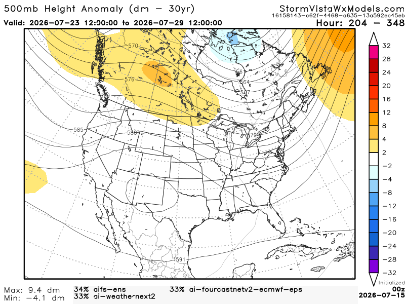
The CPC outlook has our region experiencing above-average temperatures and near-normal to above-average precipitation from July 23rd to July 29th.


Below, we have 3 of the most accurate models blended into one model. This gives us an idea of the possible outcomes from July 23rd (7 am) to July 29th (7 am). Based on this blend of models, the Southern region will continue to be hot and humid, but there won’t be an intense heat dome. Precipitation will remain normal with our afternoon and evening sea breeze thunderstorms.
3 Day City Forecast
Houston, TX:
Tonight – Mostly cloudy. Showers likely. Low of 76 °F. Calm winds.
Thursday – Partly sunny. Slight chance of thunderstorms during the day. High of 90 °F. Partly cloudy at night. Low of 79 °F. Relatively calm winds.
Friday – Mostly sunny. Slight chance of thunderstorms during the day. High of 92 °F. Mostly cloudy night. Low of 78 °F. Relatively calm winds.
Shreveport, LA:
Tonight – Mostly cloudy. Chance of thunderstorms. Low of 73 °F. Calm winds.
Thursday – Mostly sunny. High of 92 °F. Mostly clear at night. Low of 75 °F. Calm winds.
Friday – Sunny. Slight chance of thunderstorms during the day. High of 94 °F. Partly cloudy at night. Low of 76 °F. Calm winds.
Baton Rouge, LA:
Tonight – Mostly cloudy. Low of 74 °F. Calm winds.
Thursday – Sunny. High of 94 °F. Mostly clear at night. Low of 75 °F. Calm winds.
Friday – Sunny. High of 94 °F. Mostly clear at night. Low of 76 °F. Calm winds.
New Orleans, LA:
Tonight – Partly cloudy. Low of 78 °F. Calm winds.
Thursday – Sunny. High of 93 °F. Mostly clear at night. Low of 79 °F. Calm winds.
Friday – Sunny. High of 94 °F. Mostly clear at night. Low of 79 °F. Relatively calm winds.
Jackson, MS:
Tonight – Mostly clear. Slight chance of thunderstorms. Low of 72 °F. Relatively calm winds.
Thursday – Sunny. High of 92 °F. Clear at night. Low of 74 °F. Calm winds.
Friday – Sunny. High of 94 °F. Clear at night. Low of 75 °F. Calm winds.
Birmingham, AL:
Tonight – Partly cloudy. Chance of thunderstorms. Low of 72 °F. Calm winds.
Thursday – Mostly sunny. Slight chance of thunderstorms during the day. High of 89 °F. Mostly clear at night. Low of 73 °F. Relatively calm winds.
Friday – Sunny. Chance of thunderstorms during the day. High of 91 °F. Mostly clear at night. Low of 74 °F. Calm winds.
Mobile, AL:
Tonight – Mostly clear. Low of 75 °F. Relatively calm winds.
Thursday – Sunny. Slight chance of thunderstorms during the day. High of 96 °F. Mostly clear at night. Slight chance of thunderstorms. Low of 77 °F. Calm winds.
Friday – Sunny. Slight chance of showers and thunderstorms during the day. High of 98 °F. Slight chance of showers and thunderstorms. Low of 77 °F. Calm winds.
Atlanta, GA:
Tonight – Partly cloudy. Chance of thunderstorms. Low of 72 °F. Calm winds.
Thursday – Mostly sunny. Slight chance of thunderstorms during the day. High of 89 °F. Mostly clear at night. Slight chance of thunderstorms. Low of 73 °F. Relatively calm winds.
Friday – Sunny. Chance of thunderstorms during the day. High of 91 °F. Chance of showers and thunderstorms. Low of 74 °F. Relatively calm winds. Gusts up to 20 mph.
Tallahassee, FL:
Tonight – Partly cloudy. Slight chance of thunderstorms. Low of 74 °F. Calm winds.
Thursday – Mostly sunny. Slight chance of thunderstorms during the day. High of 92 °F. Slight chance of showers and thunderstorms. Low of 75 °F. Relatively calm winds. Gusts up to 20 mph.
Friday – Sunny. Thunderstorms likely during the day. High of 93 °F. Showers and thunderstorms likely. Low of 75 °F. Calm winds.
3 Day Traveling Forecast
KHOU – Houston: Slight chance of thunderstorms on Thursday and Friday during the day. Possible delays at the airport due to lightning.
KSHV – Shreveport: Chance for thunderstorms tonight and Friday. Possible delays at the airport due to lightning.
KBTR – Baton Rouge: No weather is anticipated for the next three days!
KMSY – New Orleans: No weather is anticipated for the next three days!
KJAN – Jackson: Slight chance of thunderstorms tonight. Possible delays at the airport due to lightning.
KBHM – Birmingham: Chance of thunderstorms all three days. Possible delays at the airport due to lightning.
KMOB – Mobile: Chance of thunderstorms Thursday and Friday, including at night. Possible delays at the airport due to lightning.
KATL – Atlanta: Scattered storms are capable of producing gusty winds, frequent lightning, and localized heavy rainfall all three days. Possible delays at the airport due to lightning and wind.
KTLH – Tallahassee: Chance of thunderstorms all three days. Possible delays at the airport due to lightning.
Today’s Interstate Forecast
I-10: Scattered showers and thunderstorms in the FL Panhandle. Isolated showers and possible thunderstorms in LA and TX. Storm developing in San Antonio, TX, around 11 pm. Mostly clear otherwise.
I-20: Scattered showers and thunderstorms in Central AL and Western LA. Isolated showers and possible thunderstorms near Atlanta, GA.
I-49: Scattered showers and thunderstorms in Western LA, and brief isolated showers and possible thunderstorms in Southern LA.
I-55: Scattered showers and thunderstorms near Northern MS.
I-59: Scattered showers and thunderstorms in Central AL.
I-65: Scattered showers and thunderstorms in Central AL.
I-75: Isolated showers and possible thunderstorms near Atlanta, GA and Eastern FL.


