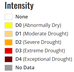
After an extended period of cooler temperatures and consistent rainfall chances, we do a hard 180 and bring in true summer heat and dry conditions. High pressure from the western US has now become the main influencer for our weather on a synoptic scale and will only look to sit over us and keep the heat on over the next 1-2 weeks. Any chances for rainfall will be largely isolated and very low at this time, with any chance for the development of showers and thunderstorms largely influenced on a mesoscale or local level instead of being triggered by a more widespread system.
Short-Term Outlook
Really over today, tomorrow, and Thursday, conditions across central and eastern Kansas will be largely similar for everyone. However, this aside, scattered showers may try to move through northern and northeastern Kansas by late this afternoon and this evening leftover from storms going through Nebraska. IF we do see showers, the most optimal time for these showers will be from 2pm to 7pm. Otherwise, over the next 2-3 days, it will be very hot and quite breezy. Temperatures will regularly be in the upper 90s to low 100s every day, with winds varying between 10-20 mph and potentially gusting up to 25-30 mph. Due to the consistently high temperatures that will affect the majority of us, the National Weather Service has issued a Heat Advisory all the way till Thursday at 9pm for all of central and eastern Kansas. Some areas may be able to get hotter than others and may warrant an Excessive Heat Warning if temperatures reach that criteria (heat indices of 105+°F for 2 hours or longer).
Long-Term Outlook
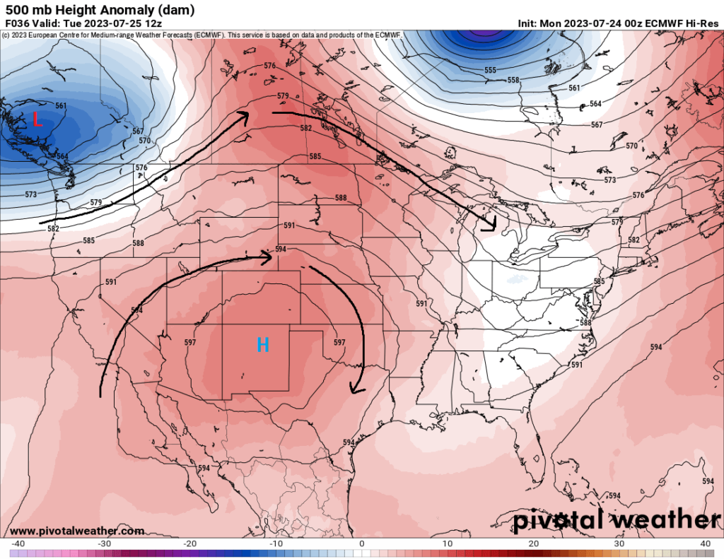
Not much will be different between what we will see over the next couple days versus what we are looking at over the next week. High pressure will continue to build over the state and keep us hot and dry, with widespread temperatures still in the upper 90s to low 100s. There is some indication of a stationary front trying to sag its way into northeastern and north-central Kansas by late week and into the weekend. This, along with the passage of a couple mid-level perturbations/disturbances, may provide a window for at least the slight potential for some isolated showers and thunderstorms starting Thursday, but chances are too low to confidently say this is a strong possibility.
Agriculture Forecast
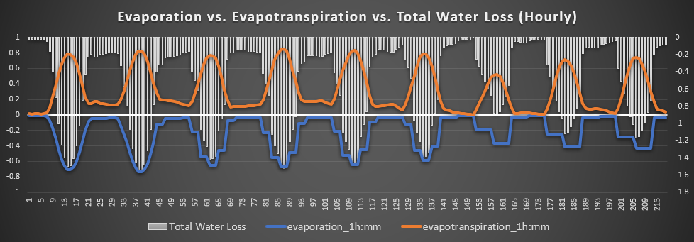
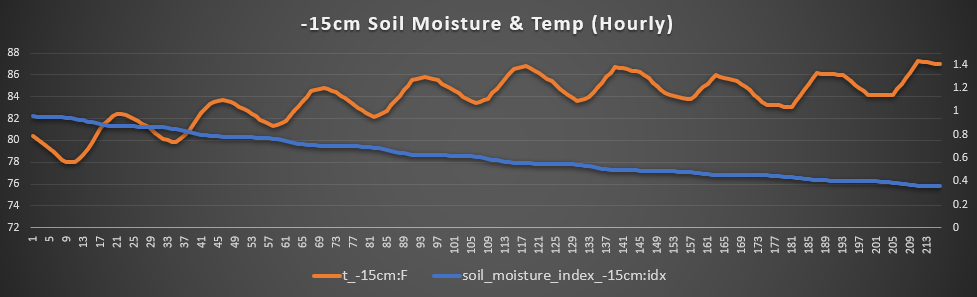
Ottawa, Lawrence, and Olathe – One location in central and eastern Kansas that has any outside shot at rain is here. But if not, soils will continue to dry out, although this area has seen a little more rainfall than others have previously, so current soil conditions are more saturated than areas to the west and south. Temperatures will hover right around the 100° mark for the rest of the week and possibly into next week as well. Winds will remain at 5-15 mph out of the south and southwest, with gusts up to 35 mph possible. Soil temperatures will be on the rise as we rack up the days of triple digit heat, peaking at 89°F by the weekend. Total water loss rates will stay somewhere between 1.1-1.3 mm/hr throughout the next 7 days, barring any days of precipitation.
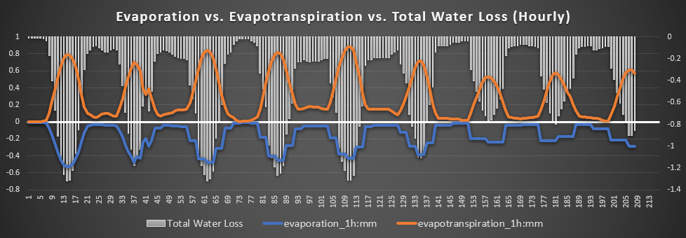
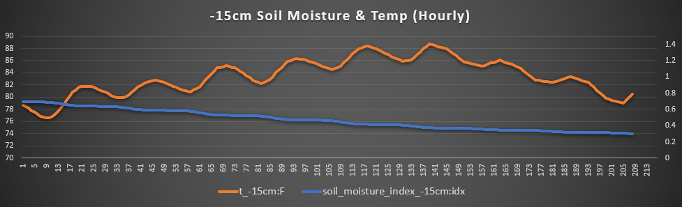
Osage City, Burlingame, and Lyndon – Very dry has this area been over recent memory, and unfortunately it does not look to get much better. Air temperatures, like many other places across the state, will be in the upper 90s to low 100s for the next week. Winds will remain breezy at 5-15 mph out of the west, with gusts of 25-35 mph possible. 15 cm soil temperatures will be steadily climbing throughout the rest of the week, peaking at 89°F by the weekend. Total water loss rates will range between 1.1-1.4 mm/hr and should remain so through the next 7 days if no tangible moisture comes with the arrival of this stationary front late in the week.
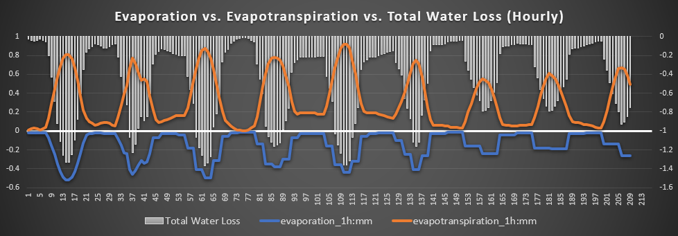
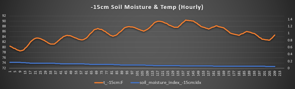
Leavenworth, Oskaloosa, and Tonganoxie – Over here in northeast Kansas, the greatest chances for some form of precipitation will exist by late week and into the weekend, if in fact there is any. Otherwise, temperatures will be in the upper 90s to low 100s until the weekend, where that aforementioned stationary front may drop further south and put this area on the cool side of the front. If this occurs, then temperatures in the low to mid 80s appear possible. Winds here will be breezy at 10-15 mph out of the southeast and southwest, with some gusts possibly approaching 25-40 mph. Soil temperatures will gradually climb throughout the week to a peak of 89°F by Saturday and Sunday before potentially tailing off by early next week. Total water loss will average around 1.3 mm/hr before dropping down to between 0.6-0.8 mm/hr by next week (assuming rainfall occurs).
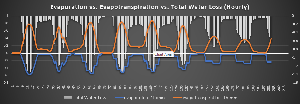
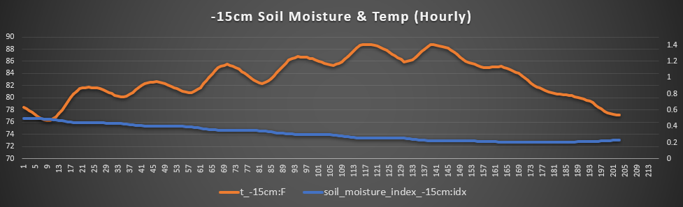
Cheney, Kingman, and Conway Springs – Probably one of the places that will be under the greatest influence from this building high pressure, down here in south-central Kansas has at least been one of the areas with the greatest soil saturation. However, this will be on the decline throughout the week. Temperatures will remain at or above 100°F over the next week, with very breezy winds mostly out of the west at 10-15 mph. Stronger gusts up to 30-35 mph may also be possible with this stiff breeze. 15 cm soil temperatures will be steadily rising throughout the week, from the (relatively) low 80°F today to the steady temperature of at least 84°F by day 3. Total water loss will be greatest over the next 5 days, peaking at 1.7 mm/hr. A decrease in this is trying to be noted by Sunday, in tandem with some modeled increase in precipitation chance, but the overall chance of rain is too low to mention at this time. If indeed there is no rainfall, total water loss rates will be close to what it previously was earlier in the week.
Climate/ENSO Update
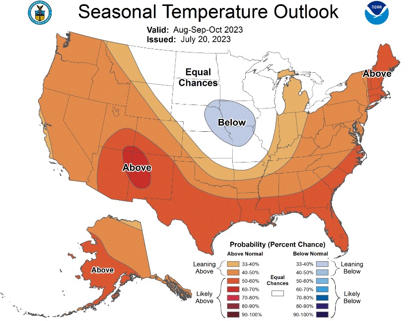
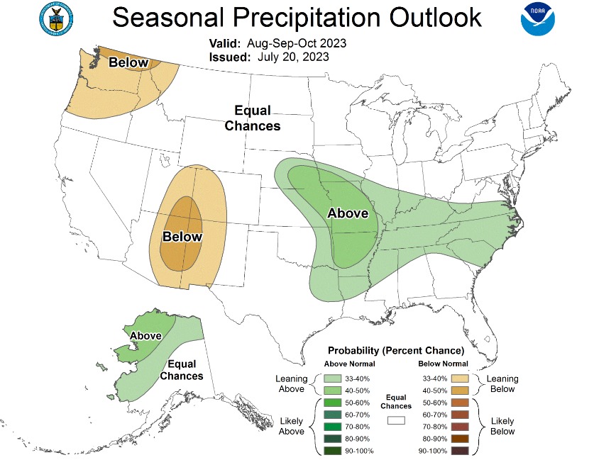
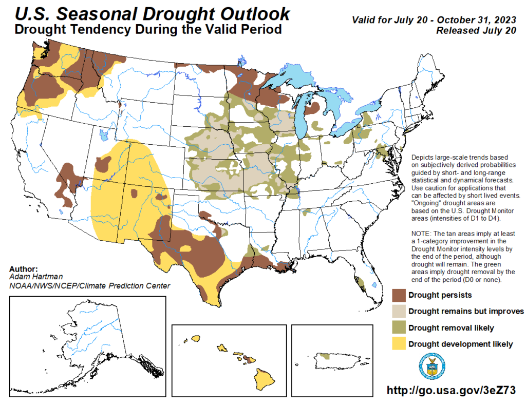
In a little more optimistic outlook, long range guidance (next 3 months) has temperature probabilities right around average to slightly below average and above average rainfall being slightly favored. Reflecting this, large areas of drought improvement or outright removal of drought conditions over this time period. Changes may be made to overall probabilities by the time the next outlook comes out next week, but let’s hope this theme will stay consistent throughout the coming weeks to hopefully bring us more much-needed relief.
ENSO conditions also remain largely unchanged, with a moderate to strong El Nino firmly in place. Conditions look to still favor at least a moderate El Nino all the way through to next Spring before we see a possible change back to more neutral conditions by late Spring/early Summer.
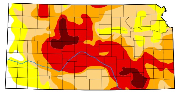
Drought Update
Overall drought conditions across central and eastern Kansas remain largely unchanged from last week. Much of central to southeast Kansas remains in extreme to exceptional drought conditions, and that is not expected to change much over the next week as we will stay very hot and dry. Rainfall departures year-to-date are still ranging between 6 inches to over 12 inches below normal for pretty much everywhere along and east of I-135.