For the rest of the week, the forecast for the coast will look like a broken record. Highs in the upper 80s to 90 and lows in the low 80s to upper 70s can be expected for the rest of the week, along with chances for pop up storms triggered by the sea breeze interacting with the land.
Things do not get that much more interesting until Monday. On Monday, a slow-moving cold front will approach the coast as it tracks through Mississippi. The map below shows a well-defined boundary between warmer air and cooler air on Monday.
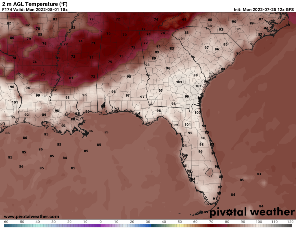
This front will produce thunderstorms as it progresses. This may raise the rain chances on Monday. The main question is whether the front will make it to the coast or whether it will stall out and become a stationary front. Still, thunderstorms forming ahead of the front should allow for heightened rain chances on Monday.
Day to Day Forecast
Tuesday
Partly cloudy with a slight chance of thunderstorms. Highs in the upper 80s. Heat index in the upper 90s. Winds SSE at 5-10 mph. Chance of rain 30 percent.
Tuesday Night
Mostly clear. Lows in the lower 80s. Chance of rain 10 percent.
Wednesday
Mostly sunny. Highs in the upper 80s. Heat index in the upper 90s. Winds SSE at 5-10 mph. Chance of rain 20 percent.
Wednesday Night
Clear. Lows in the lower 80s. Chance of rain 10 percent.
Thursday
Mostly sunny with a chance of thunderstorms. Highs around 90. Heat index in the upper 90s. Winds SSE at 5-10 mph. Chance of rain 40 percent.
Thursday Night
Mostly clear. Lows around 80. Chance of rain 10 percent.
Friday
Partly cloudy with a chance of thunderstorms. Highs around 90. Heat index in the mid 90s. Winds SSW at 5-10 mph. Chance of rain 40 percent.
Friday Night
Partly cloudy with a slight chance of thunderstorms. Lows in the upper 70s. Chance of rain 30 percent.
Saturday
Partly cloudy with a slight chance of thunderstorms. Highs around 90. Heat index in the mid 90s. Chance of rain 30 percent.
Saturday Night
Partly cloudy with a chance of thunderstorms. Lows around 80. Chance of rain 40 percent.
Sunday
Partly cloudy. Highs around 90. Heat index in the mid 90s. Winds S at 10 mph. Chance of rain 20 percent.
Sunday Night
Partly cloudy with a chance of thunderstorms. Lows in the upper 70s. Chance of rain 40 percent.
Monday
Mostly cloudy with a chance of thunderstorms. Highs around 90. Heat index in the mid 90s. Chance of rain 70 percent.
Monday Night
Mostly cloudy with a slight chance of thunderstorms. Lows in the upper 70s. Chance of rain 30 percent.


