Happy Fourth of July everyone! We got an active window of weather coming up over the next few days, with chances for scattered thunderstorms, some possibly being severe. Coinciding with this, temperatures look to finally get out of the upper 90s and down into the 80s for most of us (with a slight exception for far southeast Kansas) over the rest of the week, as we get a cold front to sweep through the area by tonight/early tomorrow morning. Let us break this down and see who could be getting what through the end of the week.
Up in the mid-levels, we are currently in the process of breaking down the area of high pressure that has sat over the Southern Plains and gave us several days of triple digit heat. Fortunately, that will be out of the way, and an incoming longwave trough with an associated cold front will move through the state and really bring us down to below average temperatures. This will also help bring some much-needed rainfall to potentially several places over the next couple days, which we could use to help continue fight these drought conditions.
Short-Term Outlook
One more hot day ahead, as today will see widespread air temperatures in the mid to upper 90s across the eastern half of Kansas. By tonight though, the rain will be a very welcome sight across the central and eastern portions of the state over the next couple of days, with many locations east of I-135 sitting at 1-2 inches below normal throughout the last two weeks. Beginning tonight though, this aforementioned cold front will enter north-central Kansas by around 9-10pm tonight and work its way through the state overnight. The storms accompanying it will enter areas around Belleville and Concordia by this 9-10pm timeframe before advancing east-southeastward, arriving in places around Topeka and McPherson by 10-11pm, Lawrence, Emporia, and El Dorado by 11pm-12am, and finally to areas around Pittsburg, Parsons, Fort Scott, and Coffeyville by 3-4am. These storms will also pose a severe threat, particularly for areas north and west of a line from McPherson to Manhattan. Damaging winds, some large hail, and localized flooding will be the primary concerns with these storms in this region before these storms gradually become more sub-severe as they advance further southeast. Temperatures throughout the day look to reach the low to mid 90s for everyone across central and eastern Kansas.
By tomorrow once the cold front passes, we should see some atmospheric recovery by the morning and afternoon hours to again support some severe thunderstorms mainly along and south of I-35/I-335, although this chance is very conditional. Scattered showers and thunderstorms may develop across this area in the morning and early afternoon hours (7am to 4pm) and move east southeastward throughout the day before completely exiting the state by the evening hours. IF we get storm development and organization, overall wind profiles will favor supercells early before a transition to a more cluster/multi-cell mode. All hazards will be possible with any storm that is able to become severe. Temperatures in front of the cold front will still get into the lower 90s, but everyone else behind the front (north and west of I-35) look to enjoy temperatures in the low to mid 80s.
Thursday will carry the potential for yet another round of showers and thunderstorms, mainly for the southern half of the state (along and south of US-50). Clusters of thunderstorms moving in from western Kansas will move through the area throughout the morning and afternoon hours (4am to 1pm) and saturate the entire area again with rainfall. These storms look to remain below severe limits at this time, although some storms reaching severe status during the afternoon hours can’t be ruled out at this time, with the main hazards being damaging winds and hail. Temperatures will continue to drop for us all on Thursday also, with average high temperatures in the low to mid 80s.
With these repeated rounds of storms, it is of note for the potential of localized flooding, especially with these storms operating in a very moist, saturated environment, with Precipitable Water (how much water could fall from a given piece of air) well above 2 inches.
Long-Term Outlook
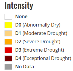
Friday through Monday will be largely the same, with daily chances for isolated to scattered showers and thunderstorms throughout the state, and temperatures much cooler (relatively speaking) in the 80s to low 90s. Overall forecasted rain totals through the next 7 days look to be widespread 1-1.5 inches, with some isolated amounts up to 2.5 inches possible as these multiple rounds of thunderstorms move through.
Agriculture Forecast
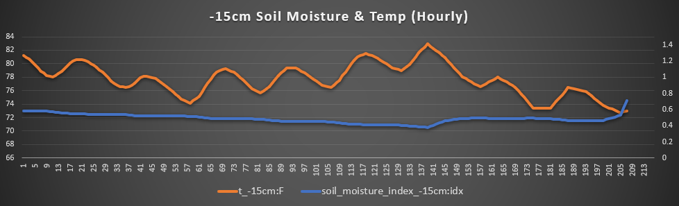
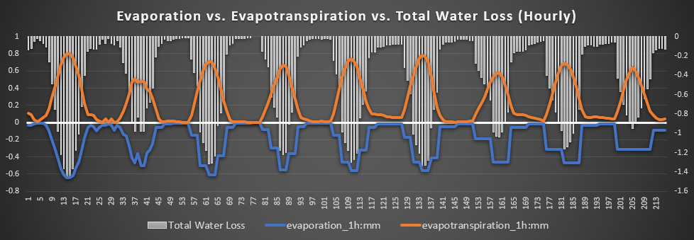
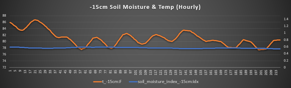
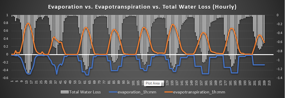
Beloit, Glasco, Minneapolis – This upcoming rainfall will be very beneficial to most over the next few days in this region. Widespread 1-1.5 inches of rainfall will help with overall soil saturation and total water loss, especially today and tomorrow (9pm-5am). Severe thunderstorms are most likely in this vicinity tonight with main concerns being straight line wind gusts of 60-70 mph. Temperatures hovering in the upper 70s to low 80s throughout the rest of the week will also help slow down evaporation and evapotranspiration rates and slow water loss rates. These continuously decreasing temperatures will also help to bring soil temperatures all the way down to the mid 70s by Friday before rising again by the weekend and early next week.
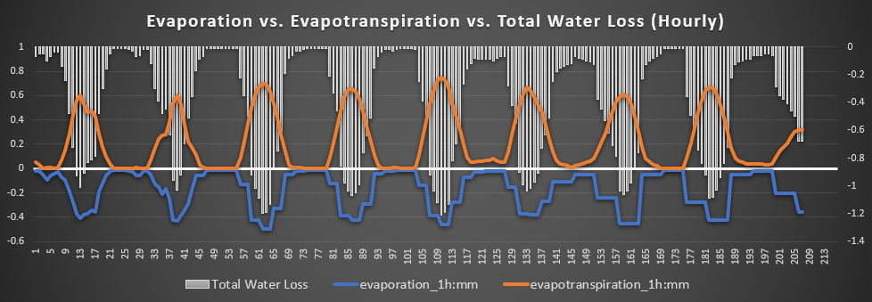
Kingman, Cheney, Conway Springs – This area here so far has had the best model consistency for the most accumulating rainfall over the next 5 days, with potential total rainfall ranging from 1-2 inches. Locally higher amounts may be possible, and repeated rounds of showers and thunderstorms may pose a flood hazard throughout the area. Severe thunderstorms may be another potential concern Wednesday morning and afternoon (7am-7pm), with all hazards possible. Temperatures in the low to mid 80s up until the weekend will also contribute to decreasing soil temperature and lessening of evaporation and water loss. Little breezy over here, with winds at 10-15 mph out of the northwest after the cold front passes before switching to out of the south-southeast by the end of the week.
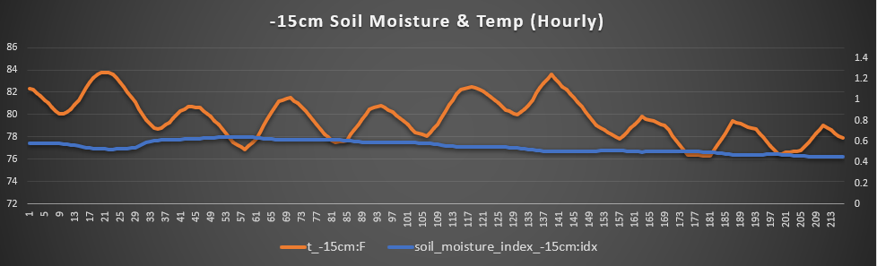
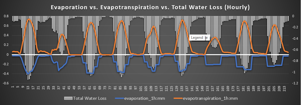
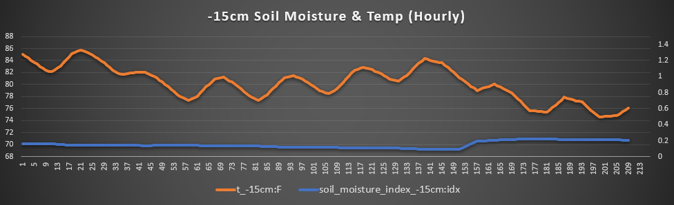
Parsons, Pittsburg, Uniontown – Out here in far southeastern Kansas is the most inconsistent when it comes to total rainfall and thunderstorm potential, with potentially only a trace amount of rainfall to upwards of 1.5-2 inches also a possibility. Best potential over the short-term will be from Wednesday at 1am to Thursday at 1pm. For now, we’ll stick with the conservative side and say up to an inch over the next 5 days. Even though this looks to be one of the warmer areas of southeastern Kansas, total water loss will be the lowest out of any other area mainly due to steadily decreasing soil temperatures and steady soil saturation from the potential for repeated rounds of rainfall Wednesday-Monday. Winds will largely be light at only 5-10 mph out of the south and southeast for the rest of the week.
Osage City, Burlingame, Lyndon – Thunderstorm potential here will be maximized tonight/tomorrow morning as this cold front passes early in the morning (11pm-12am), before more scattered thunderstorms tomorrow (2am-1pm) and Thursday (7-10am). Overall, we are still very dry here so hopefully the rain gives at least something to bring some relief. Air temperatures look to decrease down into the low 80s by the weekend, as well as continued rainfall potential every day in the near-term. Winds will generally be around 5-10 mph out of the south all the way into the weekend before steadily increasing to 10-15 mph out of the northeast by the weekend and early next week. Soil temperatures in the short-term will continue to hover in the low to mid 80s.
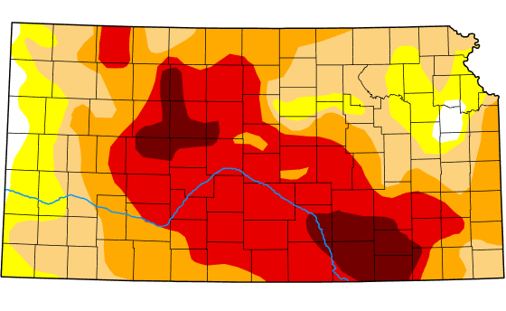
Drought Update
Above average precipitation chances and below average temperatures will be favored over the next 6-10 days. Drought improvement overall and removal in some places is still favored through the month of July. With hope, these consecutive days of showers and thunderstorms will continue to slowly chip away at the drought and return some moisture back into our very dry soils. The rest of the month, many in central and eastern Kansas could see below average temperatures, with rainfall potential largely being around average, save for northeastern Kansas where it may be slightly greater.