It is a question weather people get all the time during hurricane season. This is a common question since most of us are taught in school that tornadoes and hurricanes are separate. One happens over land, the other one happens over the water.
Tornado = land
Hurricane = water
But – like all things in the life – it isn’t that simple.
Air moves differently in different places – both horizontally and vertically
Because hurricanes are big weather systems spanning hundreds of miles across, it turns out that the air around the storm is interacting with the atmosphere differently on different sides.
And that makes sense, think about it like laying a propeller horizontally in water. If it is laid horizontally, and is spinning, and moving from one place to another, it is going to do something different to the water on one side than it would on the other.
For example: If it is moving from left to right, it will create more friction on the right side than the left as it interacts with the water around it – both horizontally and vertically.
Think about a hurricane in the same way! The atmosphere, while a bunch of different gases and not one liquid, will act similarly.
The wind from a storm is going to interact with the air above it differently on one side than it would be on the other side. Both horizontally and vertically.
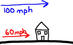
Plus, due to the friction caused by the earths surface, wind is going to – naturally – be stronger above the ground than it will be right at ground level.
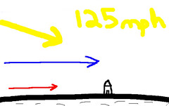
So while the wind may be from the south at 60 mph outside your door. At 1,000 feet off the ground, it might be from the south at 100 mph. Up at 10,000 feet it might be from the southwest at 125 mph!
And if there is one thing we’ve learned on this site, it is that changing wind speed and direction with height is the first ingredient you need to create a tornado!
So as air rises it will speed up and move around in a half-circle. Hmmm….
But that is only one ingredient…
Now we need to do something with all of this movement (weather nerd term: vorticity). How to we get vertical rolling action or the horizontal spinning make a funnel?
Now we need an updraft. A localized area where air is moving to higher altitudes quickly. That will pull that vertical rolling motion into a horizontal plane. And the half-circle of horizontal motion will take the air that is moving up and push it to another place. That can create a conveyor belt of weak “suction” since you are moving air from one place to another.
Think of it like an upside down drain.
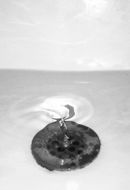
Air from the surface is being pulled up and moved to another place in the atmosphere.
Tornadoes usually form on one side of a hurricane
Because of the above-mentioned method, it means that tornadoes usually only form on the east side of a hurricane.
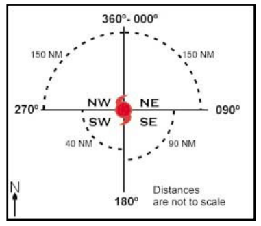
And, generally, the northeast quadrant is the most likely place to find tornadoes since it offers the greatest wind shear for land-falling tropical systems.
It doesn’t mean other places can’t see them, but the northeast side just happens to have things line up the best.


