I may be a weather nerd but, I have to say, supercell thunderstorms are pretty cool. These are some major downsides to their development (mainly the damage they can cause) but if you get to see one on radar or in person, they are often breathtaking.
From the Storms Prediction Center:
Supercells are storms — usually, but not necessarily, thunderstorms — that contain updrafts that rotate about a vertical axis. This rotation is derived from shear in the environmental wind field (that is, a change in wind direction and / or speed with height) surrounding the storm as it begins to grow. Supercells often produce damaging wind, large hail, and tornadoes, and most strong to violent tornadoes are associated with supercells. Analogous to cancer cells in a living organism, supercells differ from ordinary thunderstorms in that the rotation of their updraft enables them to overcome the self-limiting mechanisms that bring demise to regular storms. Once formed, a supercell may perpetuate itself for an appreciable length of time, even upon encountering an environment that is hostile to the development of new storms.
How do they work?
A supercell thunderstorm is a specific type of thunderstorm that uses extra dynamics – shear and helicity, in particular – to keep itself alive. Unlike a line of thunderstorms or a single cell, a supercell can pack quite the punch.
And while it may look almost like a miniature mid-latitude cyclone or may even have visual similarities to a weak hurricane – since it is a rotating storm – supercells are much, much smaller and are really quite different. Don’t let your eyes deceive you!
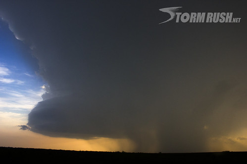
Take a look at these graphics:


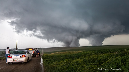
Here is a real-world example of what it would look like if you were right underneath it:
The key to a supercell is that it doesn’t rain on its own parade. A normal summer thunderstorm goes from nothing, to something, and back to nothing in about an hour or two. That is because the warm moist air it uses to build itself up – it also cuts off when it starts to precipitate.
In a supercell, the atmospheric conditions allow for the warm air (updraft) to continue even while the storm precipitates!
Evolution of a wall cloud from rain free base to mature rotating wall cloud in southeast Wisconsin in May of 2016.
Seemed perfect for the 1st day of meteorological Spring. #wiwx #wallcloud pic.twitter.com/8M3NW3D0ja— Tom Purdy (@TomPurdyWI) March 1, 2018
Notice that the storm is segmented with stuff coming into it at one spot. And stuff falling out of it in another.
Why is that?
Well supercells only form in areas where wind at different levels of the atmosphere is moving at different speeds and different directions. This allows for the warm air (updrafts) to be pushed to the side as is moves up in the storm. So as the warm air cools and starts to fall it doesn’t fall on top of the warm air that is trying to move up!
Can't get enough of this absolutely phenomenal LP supercell that I witnessed in between Wood Mountain and Coronach, Saskatchewan on June 27, 2020. #skstorm #stormhour #ShareYourWeather @PQuinlanGlobal #Saskatchewan pic.twitter.com/qMcY2TgJnn
— Gunjan Sinha PhD (@gunjansinha2017) July 2, 2020
It works a lot like a conveyor belt, really. Warm air and moist air in on one side, cool air and precipitation out on the other side. That also allows for supercell thunderstorms to last for extended periods of time – up to 12 hours! This conveyor belt, mixed with the right set of atmospheric dynamics also allows for those updrafts to rotate and for the storm to produce heavy rain, damaging wind, large hail to possibly a tornado.
From a cumulus field, comes a tornadic supercell.
Tonight in Kansas. pic.twitter.com/8R97l79rmI
— Dakota Smith (@weatherdak) July 2, 2020
Or even two tornadoes.