There are a few types of atmospheric ducting that a lot of you are probably aware of – some without thinking about it!
A lot of us have listened to a radio station from far away at night – or if we are lucky during the daylight hours – and thought, “Man! How am I picking up this signal?!” Or maybe you’ve been to a beach and looked out over the water and noticed a ‘mirage’ of a ship that wasn’t actually there.
What you are experiencing in both situations is the textbook definition is the “propagation of electromagnetic waves” through reflection and refraction in the lower atmosphere. This is often caused by an atmospheric inversion.
What is an inversion?
An inversion is a fun word to describe something that is really cool. Literally.
An inversion is when the temperature in a lower layer of the atmosphere is cooler than a layer of the atmosphere above it. If we wanted to go back to the textbook for a definition, NOAA defines an inversion as, “a layer of the atmosphere in which air temperature increases with height. When the layer’s base is at the surface, the layer is called a surface-based temperature inversion; when the base of the layer is above the surface, the layer is called an elevated temperature inversion.“

You may see posts on here with Skew-T charts. And a great way to spot an inversion within the data is by using a Skew-T (also called a sounding).
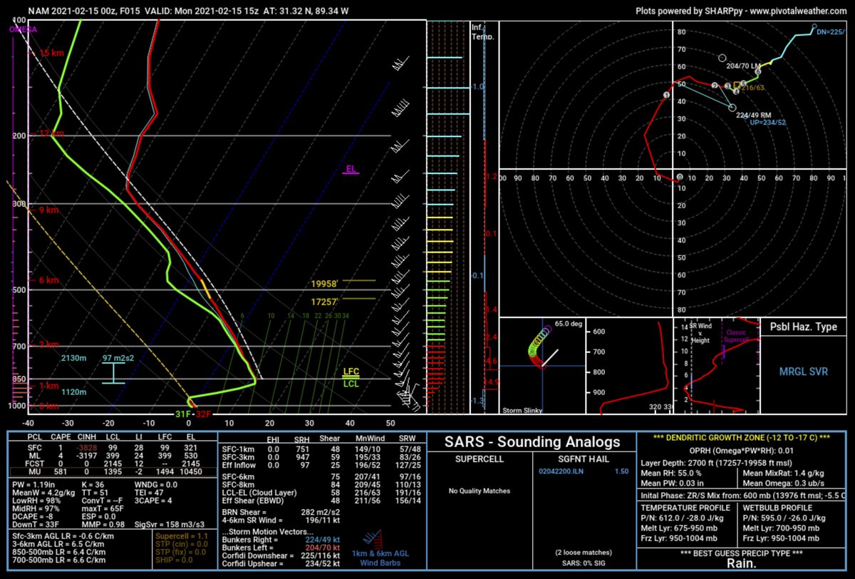
On the line graph in the upper left, you can spot the inversion where the red and green lines (in this case mostly green) move from left to right as you follow the line from the bottom (ground level) to the top (top of the atmosphere). The longer the line moves from left to right, the larger the inversion.
That warm layer of air becomes important….
We’re bouncing!
Reflection and refraction of signals off of that warm layer is how ducting can push a signal farther away from a source than usual.
atmospheric duct: A horizontal layer in the lower atmosphere in which the vertical refractive index gradients are such that radio signals (a) are guided or focused within the duct, (b) tend to follow the curvature of the Earth, and (c) experience less attenuation in the ducts than they would if the ducts were not present. (188) Note: The reduced refractive index at the higher altitudes bends the signals back toward the Earth. Signals in a higher refractive index layer, i.e., duct, tend to remain in that layer because of the reflection and refraction encountered at the boundary with a lower refractive index material.
its.bldrdoc.gov
It also works for the radar beam that the NWS uses! This allows the radar to – at times – see things that are farther away.

Most often, though, reflection of teh radar beam from an inversion allows the radar to “see” cars driving by on a highway.
Aside from being able to pick up a radio signal farther away from the radio tower than you normally could, ducting also works to bounce sound waves around, too.
A few years back Patrick whipped up a great graphic to help me explain on the evening news.
Two times, bounce-bounce
A lot like rogue waves in the ocean, rogue sound waves can occur, too. So rumbles of thunder can get really, really loud.
If you aren’t familiar with “rogue waves” that is totally understandable! Here is an example, from Tulane University, of a rogue wave can look like in the ocean.
Now, imagine instead of water waves, those are sound waves. And imagine you are the one sitting within the “10-story building” of a crack or rumble of thunder – it would shake your whole house!
And, for some places recently, that is exactly what happened. The very cold thunderstorms in south Mississippi caused this to happen due to a robust thunderstorm setup up sitting on top of a very stout inversion.
We’re going to bounce
An inversion with thunder can also make rumbles last much longer and be much deeper in frequency, too. This is because as the sound waves are bouncing around (ducting) the waves are also slowing down.
And a lot like how the pitch of a fire truck’s siren changes from higher as it drives toward you to lower as it drives away from you… the pitch of thunder gets deeper the longer it bounces around and slows down.
This type of situation can also be your first piece of evidence that the severe weather threat is minimizing during a severe weather event. Say, you had a big storm blow through – with thunder, lightning, wind, rain. Well as soon as things start to calm down, you may think, “Is this just a lull, or is it over?”
Well, if you start to hear long rumbles to thunder – perhaps loud ones, too – that may be a good indicator that an inversion is in place and the thunder is bouncing around (ducting).
While this can’t be your only indicator, it is a good first sign! It is always best to check radar, though, to be certain.


