While it feels like the 2020 Hurricane Marathon…err, I mean… Season just finished. we are about three months away from the start of the 2021 Hurricane Season.
The National Hurricane Center tweeted out the reminder on Sunday.
I’ll have some info on this upcoming season in a second. But first, I want to let you know that you are not alone if you think, “dude, really? Can we not?” because the rest of Twitter was right there with you…
I think a lot of us can relate. After – seemingly – living inside the Forecast Cone from June through October, the Gulf Coast from Brownsville, Texas to Tampa, Florida is still recovering from 2020.
But looking ahead to 2021, there are some early indicators as to what the background indicators may be.
Early Data
There are a few things (not many) that meteorologists can look at during the late Winter and Early Spring to get a head start of figuring out what Hurricane Season may look like.
Water temperatures
Between the Gulf of Mexico, the Caribbean, and the open Atlantic, the numbers are not “encouraging” at the moment. That isn’t to say things are “definitely bad” by any means, but nothing looks “good” for certain. In the Gulf, the Loop Current is still there, and probably more pronounced than it was last October


Now, looking at the “anomaly” here isn’t the best perspective for trying to assess the overall warmth of the loop current, but rather to compare it to where it should be at each respective point in time.
Right now it is much warmer than it normally is for this time of year. Even though the depth of the isotherm isn’t terribly deep.

This is the most pronounced the Loop Current has looked since 2014. And before that, in 2008.
For reference, 2014 was a season with eight total named storms, and only two got into the Gulf. Both were in the Bay of Campeche, no where near the US coastline.
2008, though, was a season with 16 named storms and seven that got into the Gulf of Mexico. Storms Dolly, Eduardo, Fay, and Gustav all tallied – eventual – Gulf Coast landfalls. Followed by Ike. And while named, Paloma never made official landfall as a tropical system.
If you’re wondering, well what did 2005 look like at this point?

This early in the year, this shouldn’t be used as a standalone indicator of a season’s potential, but rather a single spaghetti noodle on a plate of pasta.
Down in the Caribbean things are also running a bit above average. But nothing overly-dramatic to report.

And out into the open Atlantic, sadly, we are running above average across most of the basin – and particularly near the Inter-Tropical Convergence Zone.

La Nina
The ENSO cycle is an important part of seasonal hurricane outlooks because a La Nina doesn’t hinder the development of tropical systems like El Nino tends to do.
And right now we are in a La Nina pattern. From the CPC:

And the cooler waters are pretty well established across the Pacific at this time.
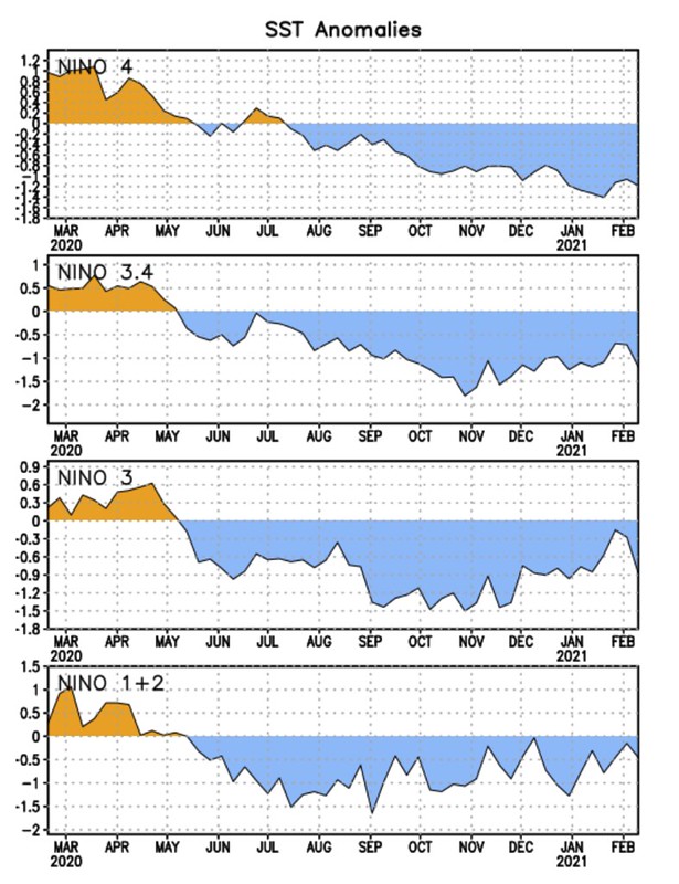
Even as we move through the Summer in the Southern Hemisphere the Nino 4 area has continued to cool, Nino 3 has spiked slightly, but fallen back off, and Nino 1+2 has shown some moderation, but is still below average.
The Forecast from the CPC suggests that La Nina continuing is the highest likelihood through Spring. But as we move toward Summer, the CPC thinks ENSO Neutral conditions may prevail.

But just as soon as Neutral takes over, LA Nina is forecast to be the most likely conditions as we head into next Fall.
Early Hurricane Season Outlook
Nothing yet.
But the persistence of a La Nina or Neutral ENSO conditions as well as above-average water temperatures across the Atlantic, Caribbean and Gulf of Mexico would lend credence to supporting an “above average” season. However, we are still too early to stick any kind of “flag in the sand” to proclaim anything.
Plus, we still have the rest of Winter and a full Spring tornado season to get through first.
One hurdle at a time.


