As I’m writing this, temperatures are in the mid-upper 80s across our region, with dew points in the muggy low-mid 70s. There is no precipitation on the radar for our area, except for the area near Tallahassee, where some light showers are lingering.


Tonight
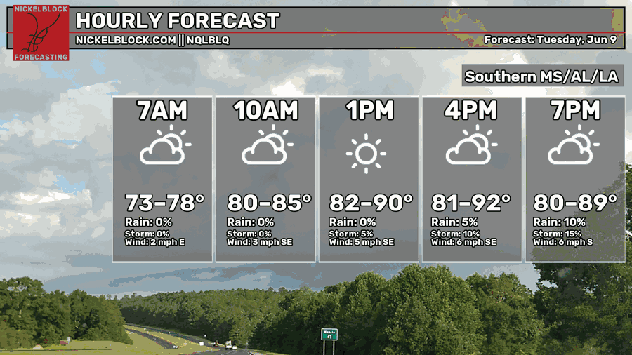
As we go into this afternoon and evening, temperatures will get quite hot, rising into the lower 90s in some places. This is due to subtropical ridging, which is ongoing. This area of high pressure off the coast of the Carolinas is causing winds from the south to bring hot and humid air into our region.
Despite the humidity, the chance for rain/storms today is low.

In the image above, there are two important lines: dew point, which is the dark blue line, and temperature, which is the red line. As you get further up into the atmosphere, at around the 700-800 milibar level, there is a large difference between the dew point and temperature, indicating that there’s a stubborn layer of warm and dry air that is suppressing thunderstorm development. This layer sticks around for the entire evening.

Storm development will be a minor issue tonight, but not a non-existent one. Some scattered storms will likely develop in south central Louisiana near Lafayette, as well as along the coast where the sea breeze will provide some lift necessary for storm development.
Tomorrow
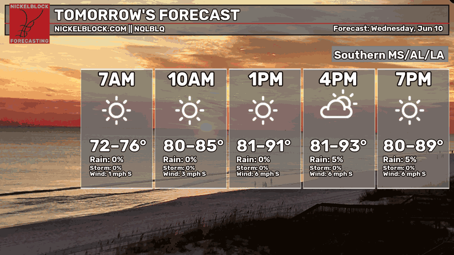
We’re in for another hot day tomorrow, with afternoon high temperatures approaching the mid 90s in some locations, and morning low temperatures only dropping into the low-mid 70s. If you’re going to be participating in outdoor activities, it’s important to stay hydrated and wear loose, cooler clothing.
Tomorrow will also remain dry like today, with only a small chance of some scattered, but weak storms developing in the afternoon and evening.
One thing that may confuse some people is why little to no storms develop even though the temperatures are plenty hot and dew points are high. While conditions are certainly conducive at the surface, the mid-upper atmosphere is a whole different story.
An area of high pressure off the coast of the Carolinas as well as one sitting south of Louisiana is bringing plenty of heat and humidity to our area. However, in an area of high pressure, the upper air sinks, compresses, and warms. Warm air can hold more moisture than cold air, so this air becomes very dry as it sinks, and dry air is more dense than moist air.
This layer of dry air acts as a lid on the layer of hot and humid air at the surface, preventing that air from rising, cooling, and creating storms that bring some relief to the heat and humidity. Tomorrow and over the next few days, this scenario will keep on repeating itself.
Another good parameter to look at when determining if pop up storms will be significant is the mid-level lapse rate. The lapse rate is the rate that temperature decreases with height. A stronger lapse rate means that air is rising faster, which usually means that stronger storms have the potential to form.

The image above is the mid level lapse rate tomorrow evening. Across our region, the lapse rate is very low, well below the dry adiabatic lapse rate of 9.8ºC/km, indicating that the mid level air is very stable and not rising. This means that stronger storms are going to have a great deal of trouble developing.
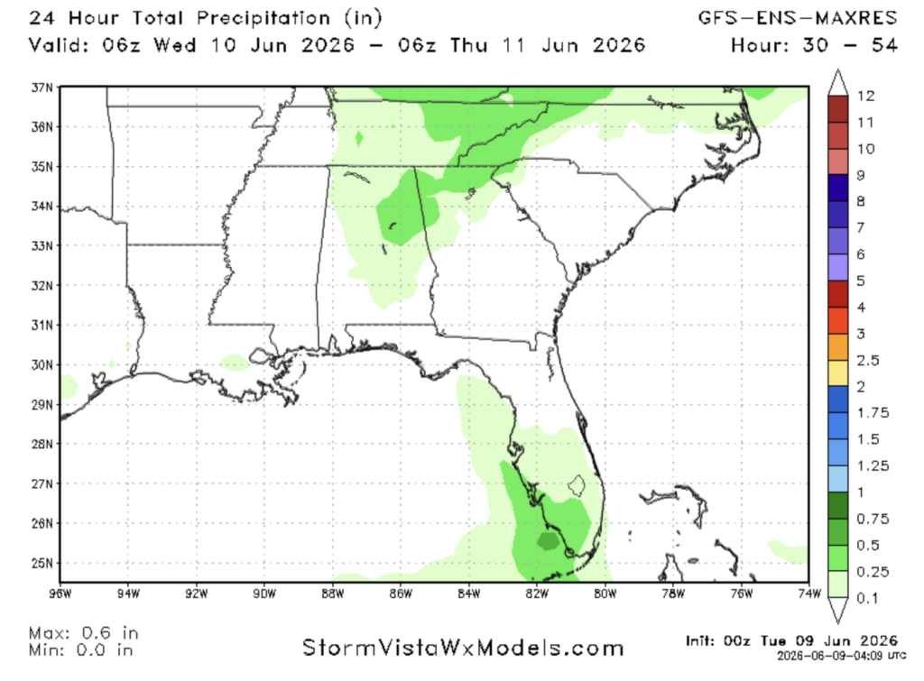
Evidently, the GFS Ensemble MAXRES model shows little to no precipitation for tomorrow along the gulf coast. The only area that may see some rain is in the area to the east of Birmingham.
Thursday

On Thursday, we’re in for more of the same: afternoon highs in the low-mid 90s with little to no chance of precipitation. Morning lows will only drop into the low 70s. Thursday will be the driest day this week.

This week, while hot and dry, will be a nice relief from the seemingly near constant rain over the past month. Some parts of southern Mississippi have seen over 6″ of rain in the past week!
The next few days will be great for sitting by the pool and/or heading to the beach. Wear sunscreen!

Extended Outlook
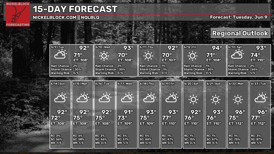
Looking ahead at the next two weeks, we’re in for some classic southern summer heat, with the high temperature each day getting into the 90s.
Until around Monday or Tuesday of next week, the same pattern of high pressure off the coast of Louisiana bringing hot and humid conditions while simultaneously suppressing storm activity is in place.

On Tuesday, the patterns switches up, with some cooler and moister air from further north possibly making its way into our region.

While this is still a bit far out, some models are hinting at a possible cold front coming through the area early next week, bringing rainfall that could be significant, and cooler temperatures, giving us relief from a week of heat.
After that, it’s back to the hot and dry pattern we’re currently stuck in.

After a brief rainy and cool period early next week, a ridge of high pressure will again build over the gulf, bringing hot temperatures and daily weak storms to our region. This is a very typical summertime weather pattern.


