It looks like next Monday and Tuesday are about to get very interesting for the area. And I expect at least some delays to regular life Tuesday with a potential for some bigger problems, too. Especially if the models continue to trend in the direction they’ve been trending for the better part of a week now.
In short:

Snow? Maybe some flurries north of I-20 and certainly closer to I-40.
For our area it will be a mixture of a cold rain, freezing rain, and sleet. And while not everyone should expect to see the worst of the worst, I woudl expec there will be enough of a risk for things to be problematic that you see school delays / closures, businesses changing hours, and general life become a bit more difficult on Tuesday morning.
The good news is that this should be a short-lived event. The bad news is that it looks like we may see some disruptions to normal life from about Monday at 6pm through about Wednesday morning at 6am.
It will be cold. It will be windy. There will be precipitation. That is a bad mixture for the central Gulf Coast.
BRIEF FORECAST DETAILS
As a shallow, arctic-based cold front slides into the area at the surface, above us, higher up in the atmosphere, there will be precipitation developing and falling tot he ground. That is setting the stage for a potential brief freezing rain / sleet event for parts of the area.
But the big question is going to be “Does the timeline for the entrance of the cold air overlap with precipitation, before the precipitation exits?”
Here is a snapshot in time, based on the model guidance, for what I mean:
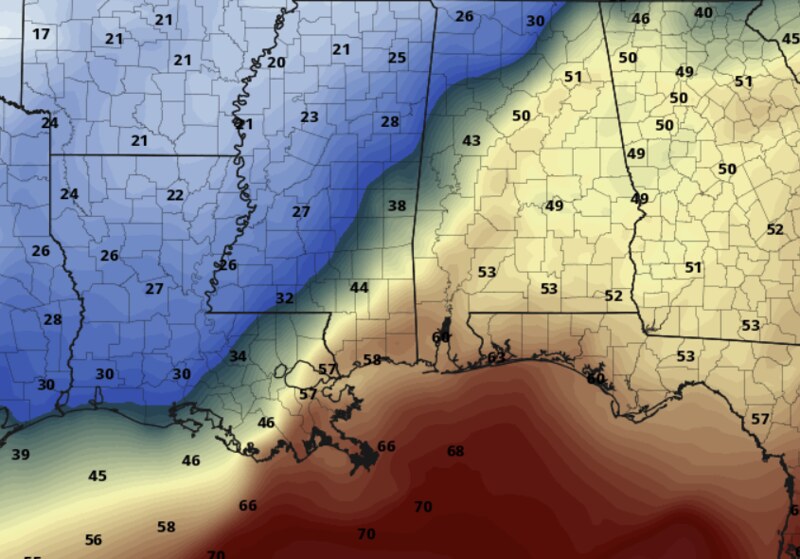

The cold air starts to press intot he area overnight Monday and into Tuesday morning. Jackson is down below freezing, but Hattiesburg is still in the mid-40s, while Mobile is still around 60F. All the while, it will be precipitating – generally near I-20 and southward.
So, in this snapshot, the precipitation totals you see on the map to the right would be partly wintry precip for Jackson, mostly liquid for Hattiesburg and fully liquid for Mobile.
The “mostly liquid” part is the difficult one to tackle, though. BEcause “mostly liquid” in an event where colder air is invading a region means a few things:
- There is a potential for a change-over from liquid to liquid-but-freezing to things (freezing rain)
- There is a potential for a change-over from liquid to frozen (sleet)
- There is a potential for a flash freeze where the liquid that falls as a liquid, then freezes a short while later when the cold air moves in and turns the water to ice before it can evaporate
Take a look at three different models that we have access to at this point. This is a look at the GFS, NAM and ECMWF. To be honest, I’m not going to tell you which is which because it doesn’t matter at thsi point and it it better if you don’t know.
These maps are a look at the total estimated freezing rain across the region.


Notice that all three show a chance for freezing rain somewhere in the region. And they all show enough freezing rain to become problematic for traveling, powerlines, and tree branches (that threshold usually starts around 0.05″)
And if you’re thinking, “yeah, well last time it looks like this, nothing happened”
Perhaps. But in the Top 15 most similar looking events, the CIPS Analogs show that 4 of the top 5 of those produced some sort of frozen precipitation at or south of I-20.

One of those analogs is the 1996 ice storm some of you may remember. Another is the Christmas Eve ice storm in 1998.
That’s not to say Tuesday will look like those days, but seeing those days in the analogs gives us an idea that the general setup is one that is conducive to producing frozen precipitation.
On top of that, once the precipitation threat comes to an end, then we will start to get markedly cooler. You will probably see maps like this floating around social media and from other outlets. But I would caution you against taking these at face value.

Often these models struggle with temperatures the first night (and sometimes the second night) near areas where new snow falls across a large area. It often ends up with temperatures 1F to 5F too cold.
That said, it is still going to be plenty cold.
THINGS THAT WILL CHANGE
Just a quick note on a few things that may change in the coming days….
- The timeline for precipitation – I tend to think, if anything, this system will continue to speed up and precipitation may begin as early as Monday afternoon.
- The timeline for the cold air – This cold air is tricky and the models are not doing a great job of timing it out. I do know that it showed up a bit earlier than anticipated across parts of Kansas on my family farm, so it is worth watching for an early arrival here, too. If so, that would increase the risk for more frozen precipitation and an increased risk for Black Ice.
- How cold it will be Wednesday morning – I’ve been very, very conservative with my forecast for the cold air. Currently the forecasts show lows in the upper teens to around 20. But there is a chance that we are a bit cooler. And any sub-24-degree temperatures are the start of pipe-bursting temperatures. So take some time this weekend to make sure pipes are insulated and protected.
- How warm it could be Wednesday afternoon – There is some model guidance that shows a warm front kicks through quickly Wednesdays morning and boosts temperatures back up into the 60s by lunch on Wednesday. I don’t know that I buy that yet, because cold air like this is really hard to move, but we may be warmer than the forecast shows currently on Wednesday afternoon.
THINGS THAT WON’T CHANGE
The chance for snow.
There is basically zero chance for snowfall. You may – if you’re lucky – see a few ice crystals flurries floating around come sunrise Tuesday morning, but that would be as close as you would get.
The temperature between the Dendritic Growth Zone and the ground is going to be too warm for real snowflakes to fall.
BRIEFLY GETTING INTO THE WEEDS
Looking at the Skew-T data, I am actually simultaneously less concerned and more concerned about hte potential for wintry weather on Tuesday morning.
Let’s start with late Monday night. The Skew-T data looks like this:

For those of you not accustomed to looking at these charts (because you aren;t a total nerd like me) what we are looking for is a few things to show up. We need temperatures to be at or near freezing, a wet-blub temperature below-freezing, some sort of Omega or forcing in an area of the atmosphere that is saturated, and if we are looking for wintry weather, we want that to happen in an area of the atmosphere that is below the freezing mark.
On the above chart, we don’t have a lot of those. We are about 38F at the surface, the wet-bulb temperature is about 36F, there is Omega in the atmosphere where it is saturated, but it is in an area that is above freezing
Okay! So, Monday night, it looks like liquid precipitation is falling. And it will be cold. Really cold.
But let’s look at the chart below, just six hours later.

We are now below-freezing at the surface, we have a below-freezing wet-bulb temperature, we have very little Omega (if any) in an area of the atmosphere that is saturated, but that area is above-freezing..
But the surface temperature is 30F and the dewpoint is 27F. So any liquid that is on the ground won’t evaporate super-fast, even as the temperature is now below-freezing.
So what happened in-between these two charts? Thsi chart:

Where the temperature is hovering near-freezing, teh wet-bulb is below-freezing, there is Omega in the saturated layer of the atmosphere, Though, the raindrops being produces are around 50F.
So there is a brief window in time when 50F rain will be falling into 33F air with a wet-bulb temperature around 31F.
Why does that matter?
The wet-bulb temperature is the temperature the air would shift to if it were suddenly saturated with water. And rainfall saturates (for all intents and purposes) the air.
So if 50F rain falls into 31F air, yes it may warm things up slightly… but it will also cool the air as the rain evaporates.
So this is our brief window for wintry precipitation. And it will mainly be freezing rain.
The reason this becomes an issue is that if you start freezing rain, it locks up the rain that is already on the ground into ice. And it is much more difficult to sublimate ice than it is to evaporate water.
The NWS is currently showing a reasonable chance that much of the area sees at least a brief round of freezing rain. And a better shot as you move northwest.


But I think my concern is more for a brief round of freezing precipitation and then cold air pushing in while it is still humid enough to keep the already-wet-ground from drying completely before we start freezing things.
THE BOTTOM LINE
Late monday night and into Tuesday morning we will see colder air invade the area. This will be some of the coldest air of the Winter. At that time there will be precipitation lingering in the area. And there is a chance that the cold air gets here while the precipitation is still falling.
TIMELINE
MONDAY – No big concerns until after 10p when liquid precipitation may change-over to freezing rain or sleet.
TUESDAY – Concerns in the morning for freezing rain or sleet between midnight and 4am. Then things dry out and get much colder. Overnight Tuesday and into Wednesday will be well-below freezing.
WEDNESDAY – Early morning concern for very cold air with temperatures below 25F in many spots and some folks will be below 20F.
On top of that there is going to be some very cold air that moves into the area that will be cold enough to pose a problem for the Four Ps: People, pets, plants and pipes.
Now is the time to insulate those pipes! Bring in the plants (if you haven’t already). And make plans to have somewhere for the pets to sleep inside. And make sure you also carve out some time to check on folks that don’t have easy access to heat.
If we do end up with any wintry precipitation prepare to be without power for up to 12 hours and prepare for that 12 hours to potentially come overnight when temperatures are below-freezing. Make sure you’ve got access to, what we called in my house, “the big quilt from Grandma” just in case.
I will try to put together a County-by-County look at things tomorrow as more higher-resolution data comes down.


