While we have a slight lull in between storms for the weekend, a strong front of cold air from the Arctic will soon push through the northern plains into the southeast bringing much stronger cold than usual. This happened around Christmas time in 2022, however we’ll also see a chance of a wintry weather mix as far south as the gulf coast.
Taking a look at the 850mb temperature anomaly above, we can see an extremely cold airmass from northwestern Canada riding down the Rockies towards most of the south. With all the cold air advection from this system, we’ll get a taste of it by Monday night into Tuesday with temperatures falling below freezing into Tuesday morning. As another front to the east carries it further towards the Atlantic, we’ll experience a much colder day on Tuesday and temperatures will dip into the teens overnight into Wednesday.
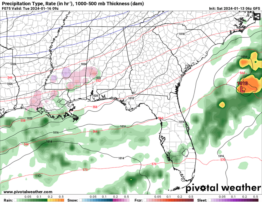
First things first, we likely won’t get any snow with this system when it travels far enough south to reach us. Most of the snow will hit areas of the northern MS/AR/LA Delta with frigid temperatures to follow. Areas south of I-20 will likely see either some sleet and freezing rain or just freezing rain. With just enough of a warm sector in the atmosphere and freezing surface temperatures, freezing rain looks likely. While it doesn’t seem like much, if we see a significant amount of freezing rain, it could affect the power grid and our roadways. Accumulated ice can be heavy and down power lines and make roadways slick (think 2014’s ice storm!). I think that most of the ice and sleet will be between Hwy 98 and I-20 in Mississippi and some of the northern counties in Louisiana, however the trend could change in the next day or so.
I will have an updated forecast tomorrow! Enjoy the weekend!
[wpcode id=”41179″]
Regional Day-to-Day Forecast
Today – Sunny, with a high near 55. Northwest wind around 5 mph becoming calm in the morning.
Tonight – Mostly cloudy, then gradual clearing toward daybreak, with a low around 33. South wind around 5 mph becoming northwest after midnight.
Sunday – Sunny, with a high near 54. North wind around 5 mph.
Sunday Night – Mostly clear, with a low around 31. Northeast wind around 5 mph.
M.L.King Day – A 20 percent chance of rain in the afternoon. Partly sunny, with a high near 57. Northeast wind around 5 mph becoming east southeast in the afternoon.
Monday Night – A chance of rain and freezing rain before sunrise. Mostly cloudy, with a low around 26. North wind 5 to 15 mph, with gusts as high as 25 mph. Chance of precipitation is 30%.
Tuesday – Mostly sunny, with a high near 36. North northwest wind around 15 mph, with gusts as high as 25 mph.
Tuesday Night – Mostly clear, with a low around 14. North northwest wind 10 to 15 mph, with gusts as high as 25 mph.
Wednesday – Sunny, with a high near 42. North northeast wind 5 to 10 mph.
Wednesday Night – Mostly clear, with a low around 23.
Thursday – A 20 percent chance of rain. Mostly sunny, with a high near 55.
Thursday Night – A 50 percent chance of rain. Mostly cloudy, with a low around 38.
Friday – A 20 percent chance of rain. Mostly sunny, with a high near 50.
[wpcode id=”41149″]


One thought on “Wintry Weather Potential Next Week – Outlook for South MS/LA/AL 1/13/24”
Comments are closed.