Coming into the beginning of the week, we’ll experience much warmer than average temperatures climbing into the 80s! It will definitely be a dry 80s with relative humidity around 35%, but we’ll slowly see the humidity pick back up by the end of the week with a possible chance of rain! Let’s take a look.

The surface analysis paints a complex story of a surface trough in the Great Lakes latching onto several moving parts. The front you notice over Oklahoma and over the Heartland will be our main point of interest. Despite all these moving parts, the front doesn’t have any driving force to move it further down to the South, or at least, not yet. The Midwestern high pressure zone I mentioned yesterday is moving towards the Atlantic and will begin to weaken over the next few days.
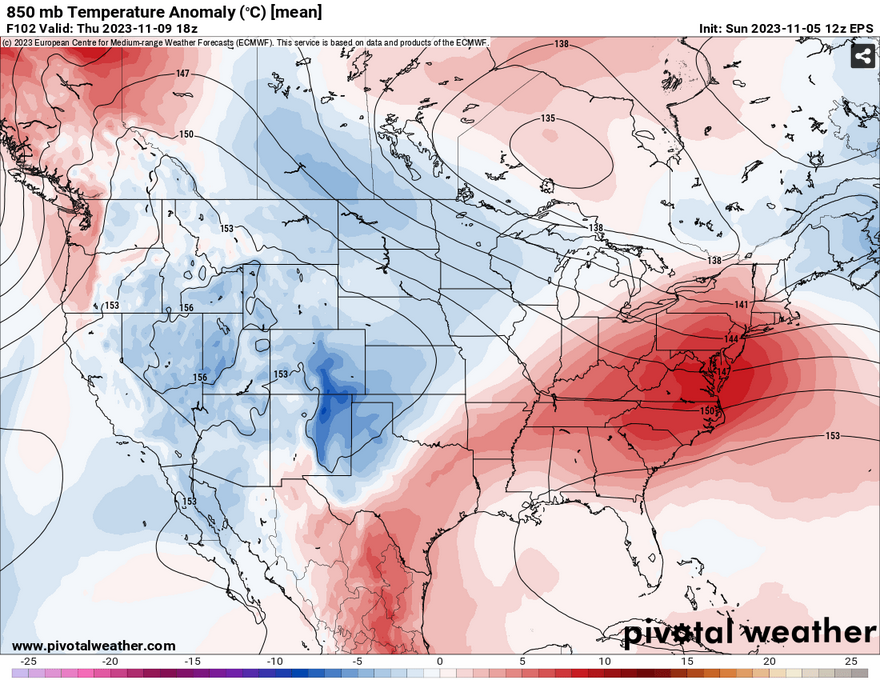
At the 850mb level, there is a decent amount of cold air and geostrophic wind to influence the front to finally start moving. This front isn’t going to be fast or bring in a blast of cold air, but it will bring a decent chance for rain. Both the European and GFS models agree that there will be some precipitation possible with this front. Amounts of a a quarter to half an inch may be possible. While it won’t likely be enough to lessen the drought, rain is very much welcome for our normally rainy November.

In terms of timing for the front, both models are saying most of Friday into Saturday morning. This is still 5 days out, so the models could push it further into the weekend or reel it back to Thursday, we’ll have to wait a little longer to find out. While this front won’t do a lot for the temperatures, it will at least knock them back down into the upper 60s to low 70s for the weekend.
Overall, it will be a pretty warm mid-Autumn week. The front will bring in some much needed rain and cool temperatures down a bit just in time for the weekend.
[wpcode id=”41179″]
Regional Day-to-Day Forecast
Tonight – Partly cloudy, with a low around 50. Calm wind.
Monday – Mostly sunny, with a high near 81. Calm wind becoming southwest around 5 mph in the afternoon.
Monday Night – Partly cloudy, with a low around 53. South wind around 5 mph becoming calm after midnight.
Tuesday – Sunny, with a high near 83. Light southwest wind increasing to 5 to 10 mph in the morning.
Tuesday Night – Mostly clear, with a low around 56. South wind around 5 mph.
Wednesday – Mostly sunny, with a high near 82. South southwest wind 5 to 10 mph, with gusts as high as 20 mph.
Wednesday Night – Mostly cloudy, with a low around 58. South wind 5 to 10 mph becoming light after midnight. Winds could gust as high as 20 mph.
Thursday – Mostly cloudy, with a high near 81. Calm wind becoming south southwest around 5 mph in the morning.
Thursday Night – A 50 percent chance of rain. Cloudy, with a low around 61. South southwest wind around 5 mph becoming calm.
Friday – A 40 percent chance of showers. Cloudy, with a high near 71.
Friday Night – A 20 percent chance of rain. Mostly cloudy, with a low around 54.
Saturday – Partly sunny, with a high near 70.
Saturday Night – Mostly cloudy, with a low around 53.
Sunday – Mostly cloudy, with a high near 69.
[wpcode id=”41149″]


