After a few days of intermittent rainfall and sticky conditions, we’re going back to the cool and dry that we all know December for. Temperatures will dip back down to the 50s and 60s for the better part of the week and we’ll see a couple of frosty mornings ahead of us too.

On the synoptic scale, a myriad of shortwave troughs from the upper levels will move through the eastern US. For the deep south in particular, the troughs are dry and will pull in more Arctic air from the north and keep temperatures down and the skies fairly clear. Temperatures will likely reach the freezing point on Tuesday and Wednesday. By Thursday, the strong height anomaly you see above (in red) will allow the heights to rise and with that, temperatures will also be on the rise. Couple that with winds from the south in the Gulf, we’ll see more of the build-up of warmer, more humid conditions by Thursday and Friday.
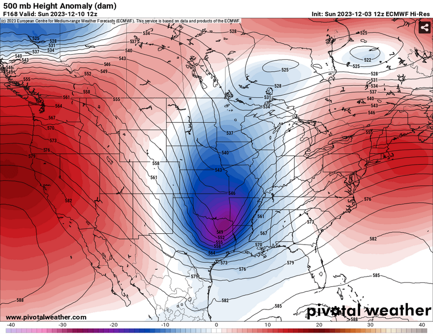
As shown above, another significant trough will develop around Saturday into Sunday, and with it, another chance for storms. This is still pretty far out, but both the GFS and Euro models agree that this will be a fairly organized line of storms. Judging by the orientation of the trough, it reaches down far enough to raise an eyebrow as to what may happen next weekend. For now, we’ll have to wait until we get a bit closer to the weekend to see what possible parameters and significant threats may come with this system.

[wpcode id=”41179″]
Regional Day-to-Day Forecast
Tonight – Mostly cloudy, with a low around 48. Calm wind.
Monday – Mostly sunny, with a high near 66. West southwest wind 5 to 10 mph becoming northwest in the afternoon. Winds could gust as high as 20 mph.
Monday Night – Partly cloudy, with a low around 39. Northwest wind around 5 mph becoming calm in the evening.
Tuesday – Mostly sunny, with a high near 65. Light and variable wind becoming west northwest 5 to 10 mph in the morning.
Tuesday Night – Mostly clear, with a low around 38. Northwest wind around 5 mph becoming calm after midnight.
Wednesday – Sunny, with a high near 58. North wind 5 to 10 mph, with gusts as high as 20 mph.
Wednesday Night – Mostly clear, with a low around 34. Calm wind.
Thursday – Mostly sunny, with a high near 62. Calm wind becoming south southeast around 5 mph in the morning.
Thursday Night – Partly cloudy, with a low around 40. South southeast wind around 5 mph.
Friday – Sunny, with a high near 70.
Friday Night – A 20 percent chance of rain. Partly cloudy, with a low around 51.
Saturday – A 40 percent chance of showers and thunderstorms. Partly sunny, with a high near 72.
Saturday Night – Showers likely and possibly a thunderstorm. Mostly cloudy, with a low around 45. Chance of precipitation is 60%.
Sunday – A 50 percent chance of showers and thunderstorms. Mostly sunny, with a high near 59.
[wpcode id=”41149″]


