The Moderate Risk for severe weather continues across all of Mississippi, parts of Louisiana, Alabama, Floriea, Tennessee and Arkansas.

And the SPC is leaving very little to the imagination. They are most concerned for areas south of I-20.
From the SPC:
The most-favorable parameter space still appears to be across the “moderate” area, where the greatest wind and tornado probabilities are drawn (including at least 10% significant-severe levels). In a northward-narrowing wedge of favorable warm-sector boundary layer, mid/upper 60s F surface dew points should become common from the Gulf Coast to parts of the Mid-South. Though diurnal heating will be modest over most of the area, a combination of theta-e advection and cooling aloft will contribute to MLCAPE ranging from 500-1500 J/kg over parts of LA/MS/AL mainly south of I-20.
Shear will be strong across the entire region, as 90-110 kt of 700-500-mb layer flow develop ahead of the ejecting shortwave trough over the Mid-South, along with a broad, 60-85-kt LLJ. Forecast soundings reasonably depict 50-70 kt effective-shear magnitudes, along with large, well-curved hodographs fostering 300-600 J/kg effective SRH (locally higher). This will support line-embedded tornadic supercells and LEWP/mesovortex features, as well as bowing segments to locally maximize destructive-wind potential.
Any preceding, sustained supercells that do develop would be fast-moving (around 50 kt based on the Bunkers algorithm), with potential for long tornado tracks if storm-scale occlusions are not very rapid. Downward momentum transfer from layers of intense gradient flow in low/middle-levels also my augment the severe-downdraft threat, with bursts of hurricane-force gusts possible.
The 12z models came back with some increased spread within the Updraft Helicity Streaks. And it has shifted the risk farther south, too.
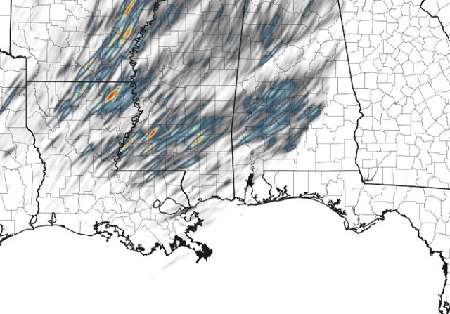


Recall that the Updraft Helicity Streaks are when the computer models use an equation to try and find where the strongest storms my be. And they do this by finding where rotating storms will be possible.
Looking at the HREF modeling from the SPC, and allowing the computer models to pick out where the strongest UH streaks will be and highlighting an area with the highest risk for the strongest storms within the area already highlighted for a risk.

You can think of it at picking out the fastest car in a field of 20 getting read to race at the race track, relative to the cars that people drive on your street. It is, like, a third tier.
So the model data lines up with what the SPC is forecasting and talking about in their discussion above.
With all of that said, I think the morning forecast mostly holds. The tornado risk is, again, slightly higher than six hours ago and increased the wind speed potential. But otherwise the forecast is the same. Thus, there is not much that has changed to the “Main Concerns” for today.
MAIN CONCERNS
||| Between Wed 2p through 11p |||
Brief heavy rain
Localized flash flooding
Frequent lightning
Wind gusts up to 75mph (perhaps higher)
Small Hail
Multiple brief tornadoes
A few long-track tornado-producing storms
Tornadoes up to EF-3 in strength
During this (and previous) event, people have asked if there is a way to “‘help’ or ‘say thanks’ for all of the forecasting work I do. For the longest time I said, ‘nah! I just like doing this! You know, to help!’ But I was recently convinced that others want to ‘help’ in their own way, too.
And their way of helping, or simply saying ‘thank you’ is with a donation to the blog to help keep it running – or to help keep me running. So I’ve added this link. If you are one of those people, let me say thank you to YOU.
County-by-County Timeline
A quick reminder that this timeline doesn’t mean that the entire time it will be raining and storming. It is an attempt to give you the best window of opportunity for storms to be near you. A three to four hour window may only feature rain and storms for 30-45 minutes. But the goal is to highlight a window where the threat is higher than at other times.
Also, just because there is a potential for severe weather doesn’t mean that everyone is going to see the worst of the worst. For the moment, here is a look at the threats by general population:
During the highlighted times below
EVERYONE — Brief heavy rain, lightning, and wind gusts up to 50mph
MOST AREAS — Heavy rain, lightning, wind gusts up to 60mph
MANY PEOPLE — Heavy rain, localized flooding, wind gusts up to 65mph, small hail
SOME PLACES — Heavy rain, localized flooding, wind gusts exceeding 70mph, small hail,
FEW SPOTS — Heavy rain, localized flooding, wind gusts exceeding 75mph, small hail, a tornado up to EF-3 in strength
Louisiana
St. Helena Parish
Wednesday 1p-4p — Breezy. Isolated showers with few rumbles of thunder developing early, very few (if any) storms may be strong to severe before 4p. Main threats with any storm will be heavy rain, frequent lightning, gusty wind, small hail, and a tornado can not be ruled out.
Wednesday 4p-7p — Showers and storms likely, many strong with a handful severe. Main threats with stronger storms will be very heavy rain, frequent lightning, wind gusts up to 70mph, hail up to the size of quarters, and the potential for a tornado (up to EF3 in strength).
Wednesday 7p-10p — Storms ending. Turning cooler and breezy.
Tangipahoa Parish
Wednesday 1p-4p — Breezy. Isolated showers with few rumbles of thunder developing early, very few (if any) storms may be strong to severe before 4p. Main threats with any storm will be heavy rain, frequent lightning, gusty wind, small hail, and a tornado can not be ruled out.
Wednesday 4p-7p — Showers and storms likely, many strong with a handful severe. Main threats with stronger storms will be very heavy rain, frequent lightning, wind gusts up to 70mph, hail up to the size of quarters, and the potential for a tornado (up to EF3 in strength).
Wednesday 7p-10p — Storms ending. Turning cooler and breezy.
Washington Parish
Wednesday 1p-4p — Breezy. Isolated showers with few rumbles of thunder developing early, very few (if any) storms may be strong to severe before 4p. Main threats with any storm will be heavy rain, frequent lightning, gusty wind, small hail, and a tornado can not be ruled out.
Wednesday 4p-7p — Showers and storms likely, many strong with a handful severe. Main threats with stronger storms will be very heavy rain, frequent lightning, wind gusts up to 70mph, hail up to the size of quarters, and the potential for a tornado (up to EF3 in strength).
Wednesday 7p-10p — Storms ending. Turning cooler and breezy.
Livingston Parish
Wednesday 1p-4p — Breezy. Isolated showers with few rumbles of thunder developing early, very few (if any) storms may be strong to severe before 4p. Main threats with any storm will be heavy rain, frequent lightning, gusty wind, small hail, and a tornado can not be ruled out.
Wednesday 4p-7p — Showers and storms likely, many strong with a handful severe. Main threats with stronger storms will be very heavy rain, frequent lightning, wind gusts up to 70mph, hail up to the size of quarters, and the potential for a tornado (up to EF3 in strength).
Wednesday 7p-10p — Storms ending. Turning cooler and breezy.
St. Tammany Parish
Wednesday 1p-4p — Breezy. Isolated showers with few rumbles of thunder developing early, very few (if any) storms may be strong to severe before 4p. Main threats with any storm will be heavy rain, frequent lightning, gusty wind, small hail, and a tornado can not be ruled out.
Wednesday 4p-7p — Showers and storms likely, many strong with a handful severe. Main threats with stronger storms will be very heavy rain, frequent lightning, wind gusts up to 70mph, hail up to the size of quarters, and the potential for a tornado (up to EF3 in strength).
Wednesday 7p-10p — Storms ending. Turning cooler and breezy.
Mississippi
NEAR I-20
Copiah County
Wednesday 2p-6p — Showers and storms likely, many strong with a handful severe. Main threats with stronger storms will be very heavy rain, frequent lightning, wind gusts up to 70mph, hail up to the size of quarters, and the potential for a tornado (up to EF3 in strength).
Wednesday 6p-10p — Storms ending. Turning cooler and breezy.
Simpson County
Wednesday 2p-6p — Showers and storms likely, many strong with a handful severe. Main threats with stronger storms will be very heavy rain, frequent lightning, wind gusts up to 70mph, hail up to the size of quarters, and the potential for a tornado (up to EF3 in strength).
Wednesday 6p-10p — Storms ending. Turning cooler and breezy.
Smith County
Wednesday 2p-6p — Breezy. Isolated showers with few rumbles of thunder developing early, very few (if any) storms may be strong to severe before 6p. Main threats with any storm will be heavy rain, frequent lightning, gusty wind, small hail, and a tornado can not be ruled out.
Wednesday 6p-10p — Showers and storms likely, many strong with a handful severe. Main threats with stronger storms will be very heavy rain, frequent lightning, wind gusts up to 70mph, hail up to the size of quarters, and the potential for a tornado (up to EF3 in strength).
Wednesday 10p-Thursday 2a — Storms ending. Turning cooler and breezy.
Jasper County
Wednesday 2p-6p — Breezy. Isolated showers with few rumbles of thunder developing early, very few (if any) storms may be strong to severe before 6p. Main threats with any storm will be heavy rain, frequent lightning, gusty wind, small hail, and a tornado can not be ruled out.
Wednesday 6p-10p — Showers and storms likely, many strong with a handful severe. Main threats with stronger storms will be very heavy rain, frequent lightning, wind gusts up to 70mph, hail up to the size of quarters, and the potential for a tornado (up to EF3 in strength).
Wednesday 10p-Thursday 2a — Storms ending. Turning cooler and breezy.
Clarke County
Wednesday 2p-6p — Breezy. Isolated showers with few rumbles of thunder developing early, very few (if any) storms may be strong to severe before 6p. Main threats with any storm will be heavy rain, frequent lightning, gusty wind, small hail, and a tornado can not be ruled out.
Wednesday 6p-10p — Showers and storms likely, many strong with a handful severe. Main threats with stronger storms will be very heavy rain, frequent lightning, wind gusts up to 70mph, hail up to the size of quarters, and the potential for a tornado (up to EF3 in strength).
Wednesday 10p-Thursday 2a — Storms ending. Turning cooler and breezy.
HIGHWAY 84 CORRIDOR
Lincoln County
Wednesday 2p-6p — Showers and storms likely, many strong with a handful severe. Main threats with stronger storms will be very heavy rain, frequent lightning, wind gusts up to 70mph, hail up to the size of quarters, and the potential for a tornado (up to EF3 in strength).
Wednesday 6p-10p — Storms ending. Turning cooler and breezy.
Lawrence County
Wednesday 2p-6p — Showers and storms likely, many strong with a handful severe. Main threats with stronger storms will be very heavy rain, frequent lightning, wind gusts up to 70mph, hail up to the size of quarters, and the potential for a tornado (up to EF3 in strength).
Wednesday 6p-10p — Storms ending. Turning cooler and breezy.
Jeff Davis County
Wednesday 2p-6p — Breezy. Isolated showers with few rumbles of thunder developing early, very few (if any) storms may be strong to severe before 5p. Main threats with any storm will be heavy rain, frequent lightning, gusty wind, small hail, and a tornado can not be ruled out.
Wednesday 6p-10p — Showers and storms likely, many strong with a handful severe. Main threats with stronger storms will be very heavy rain, frequent lightning, wind gusts up to 70mph, hail up to the size of quarters, and the potential for a tornado (up to EF3 in strength).
Wednesday 10p-Thursday 2a — Storms ending. Turning cooler and breezy.
Covington County
Wednesday 2p-6p — Breezy. Isolated showers with few rumbles of thunder developing early, very few (if any) storms may be strong to severe before 6p. Main threats with any storm will be heavy rain, frequent lightning, gusty wind, small hail, and a tornado can not be ruled out.
Wednesday 6p-10p — Showers and storms likely, many strong with a handful severe. Main threats with stronger storms will be very heavy rain, frequent lightning, wind gusts up to 70mph, hail up to the size of quarters, and the potential for a tornado (up to EF3 in strength).
Wednesday 10p-Thursday 2a — Storms ending. Turning cooler and breezy.
Jones County
Wednesday 2p-6p — Breezy. Isolated showers with few rumbles of thunder developing early, very few (if any) storms may be strong to severe before 6p. Main threats with any storm will be heavy rain, frequent lightning, gusty wind, small hail, and a tornado can not be ruled out.
Wednesday 6p-10p — Showers and storms likely, many strong with a handful severe. Main threats with stronger storms will be very heavy rain, frequent lightning, wind gusts up to 70mph, hail up to the size of quarters, and the potential for a tornado (up to EF3 in strength).
Wednesday 10p-Thursday 2a — Storms ending. Turning cooler and breezy.
Wayne County
Wednesday 2p-6p — Breezy. Isolated showers with few rumbles of thunder developing early, very few (if any) storms may be strong to severe before 6p. Main threats with any storm will be heavy rain, frequent lightning, gusty wind, small hail, and a tornado can not be ruled out.
Wednesday 6p-10p — Showers and storms likely, many strong with a handful severe. Main threats with stronger storms will be very heavy rain, frequent lightning, wind gusts up to 70mph, hail up to the size of quarters, and the potential for a tornado (up to EF3 in strength).
Wednesday 10p-Thursday 2a — Storms ending. Turning cooler and breezy.
HIGHWAY 98 CORRIDOR
Pike County
Wednesday 2p-6p — Showers and storms likely, many strong with a handful severe. Main threats with stronger storms will be very heavy rain, frequent lightning, wind gusts up to 70mph, hail up to the size of quarters, and the potential for a tornado (up to EF3 in strength).
Wednesday 6p-10p — Storms ending. Turning cooler and breezy.
Walthall County
Wednesday 2p-6p — Showers and storms likely, many strong with a handful severe. Main threats with stronger storms will be very heavy rain, frequent lightning, wind gusts up to 70mph, hail up to the size of quarters, and the potential for a tornado (up to EF3 in strength).
Wednesday 6p-10p — Storms ending. Turning cooler and breezy.
Marion County
Wednesday 2p-6p — Breezy. Isolated showers with few rumbles of thunder developing early, very few (if any) storms may be strong to severe before 5p. Main threats with any storm will be heavy rain, frequent lightning, gusty wind, small hail, and a tornado can not be ruled out.
Wednesday 6p-10p — Showers and storms likely, many strong with a handful severe. Main threats with stronger storms will be very heavy rain, frequent lightning, wind gusts up to 70mph, hail up to the size of quarters, and the potential for a tornado (up to EF3 in strength).
Wednesday 10p-Thursday 2a — Storms ending. Turning cooler and breezy.
Lamar County
Wednesday 2p-6p — Breezy. Isolated showers with few rumbles of thunder developing early, very few (if any) storms may be strong to severe before 6p. Main threats with any storm will be heavy rain, frequent lightning, gusty wind, small hail, and a tornado can not be ruled out.
Wednesday 6p-10p — Showers and storms likely, many strong with a handful severe. Main threats with stronger storms will be very heavy rain, frequent lightning, wind gusts up to 70mph, hail up to the size of quarters, and the potential for a tornado (up to EF3 in strength).
Wednesday 10p-Thursday 2a — Storms ending. Turning cooler and breezy.
Forrest County
Wednesday 2p-6p — Breezy. Isolated showers with few rumbles of thunder developing early, very few (if any) storms may be strong to severe before 6p. Main threats with any storm will be heavy rain, frequent lightning, gusty wind, small hail, and a tornado can not be ruled out.
Wednesday 6p-10p — Showers and storms likely, many strong with a handful severe. Main threats with stronger storms will be very heavy rain, frequent lightning, wind gusts up to 70mph, hail up to the size of quarters, and the potential for a tornado (up to EF3 in strength).
Wednesday 10p-Thursday 2a — Storms ending. Turning cooler and breezy.
Perry County
Wednesday 2p-6p — Breezy. Isolated showers with few rumbles of thunder developing early, very few (if any) storms may be strong to severe before 6p. Main threats with any storm will be heavy rain, frequent lightning, gusty wind, small hail, and a tornado can not be ruled out.
Wednesday 6p-10p — Showers and storms likely, many strong with a handful severe. Main threats with stronger storms will be very heavy rain, frequent lightning, wind gusts up to 70mph, hail up to the size of quarters, and the potential for a tornado (up to EF3 in strength).
Wednesday 10p-Thursday 2a — Storms ending. Turning cooler and breezy.
Greene County
Wednesday 2p-6p — Breezy. Isolated showers with few rumbles of thunder developing early, very few (if any) storms may be strong to severe before 6p. Main threats with any storm will be heavy rain, frequent lightning, gusty wind, small hail, and a tornado can not be ruled out.
Wednesday 6p-10p — Showers and storms likely, many strong with a handful severe. Main threats with stronger storms will be very heavy rain, frequent lightning, wind gusts up to 70mph, hail up to the size of quarters, and the potential for a tornado (up to EF3 in strength).
Wednesday 10p-Thursday 2a — Storms ending. Turning cooler and breezy.
HIGHWAY 26 CORRIDOR
Pearl River County
Wednesday 2p-6p — Breezy. Isolated showers with few rumbles of thunder developing early, very few (if any) storms may be strong to severe before 5p. Main threats with any storm will be heavy rain, frequent lightning, gusty wind, small hail, and a tornado can not be ruled out.
Wednesday 6p-10p — Showers and storms likely, many strong with a handful severe. Main threats with stronger storms will be very heavy rain, frequent lightning, wind gusts up to 70mph, hail up to the size of quarters, and the potential for a tornado (up to EF3 in strength).
Wednesday 10p-Thursday 2a — Storms ending. Turning cooler and breezy.
Stone County
Wednesday 2p-6p — Breezy. Isolated showers with few rumbles of thunder developing early, very few (if any) storms may be strong to severe before 6p. Main threats with any storm will be heavy rain, frequent lightning, gusty wind, small hail, and a tornado can not be ruled out.
Wednesday 6p-10p — Showers and storms likely, many strong with a handful severe. Main threats with stronger storms will be very heavy rain, frequent lightning, wind gusts up to 70mph, hail up to the size of quarters, and the potential for a tornado (up to EF3 in strength).
Wednesday 10p-Thursday 2a — Storms ending. Turning cooler and breezy.
George County
Wednesday 2p-6p — Breezy. Isolated showers with few rumbles of thunder developing early, very few (if any) storms may be strong to severe before 6p. Main threats with any storm will be heavy rain, frequent lightning, gusty wind, small hail, and a tornado can not be ruled out.
Wednesday 6p-10p — Showers and storms likely, many strong with a handful severe. Main threats with stronger storms will be very heavy rain, frequent lightning, wind gusts up to 70mph, hail up to the size of quarters, and the potential for a tornado (up to EF3 in strength).
Wednesday 10p-Thursday 2a — Storms ending. Turning cooler and breezy.
COASTAL MISSISSIPPI
Jackson County
Wednesday 2p-6p — Breezy. Isolated showers with few rumbles of thunder developing early, very few (if any) storms may be strong to severe before 6p. Main threats with any storm will be heavy rain, frequent lightning, gusty wind, small hail, and a tornado can not be ruled out.
Wednesday 6p-10p — Showers and storms likely, many strong with a handful severe. Main threats with stronger storms will be very heavy rain, frequent lightning, wind gusts up to 70mph, hail up to the size of quarters, and the potential for a tornado (up to EF3 in strength).
Wednesday 10p-Thursday 2a — Storms ending. Turning cooler and breezy.
Harrison County
Wednesday 2p-6p — Breezy. Isolated showers with few rumbles of thunder developing early, very few (if any) storms may be strong to severe before 6p. Main threats with any storm will be heavy rain, frequent lightning, gusty wind, small hail, and a tornado can not be ruled out.
Wednesday 6p-10p — Showers and storms likely, many strong with a handful severe. Main threats with stronger storms will be very heavy rain, frequent lightning, wind gusts up to 70mph, hail up to the size of quarters, and the potential for a tornado (up to EF3 in strength).
Wednesday 10p-Thursday 2a — Storms ending. Turning cooler and breezy.
Hancock County
Wednesday 2p-6p — Breezy. Isolated showers with few rumbles of thunder developing early, very few (if any) storms may be strong to severe before 6p. Main threats with any storm will be heavy rain, frequent lightning, gusty wind, small hail, and a tornado can not be ruled out.
Wednesday 6p-10p — Showers and storms likely, many strong with a handful severe. Main threats with stronger storms will be very heavy rain, frequent lightning, wind gusts up to 70mph, hail up to the size of quarters, and the potential for a tornado (up to EF3 in strength).
Wednesday 10p-Thursday 2a — Storms ending. Turning cooler and breezy.
Alabama
Sumter County
Wednesday 4p-8p — Breezy. Isolated showers with few rumbles of thunder developing early, very few (if any) storms may be strong to severe before 7p. Main threats with any storm will be heavy rain, frequent lightning, gusty wind, small hail, and a tornado can not be ruled out.
Wednesday 8p-Thursday 2a — Showers and storms likely, many strong with a handful severe. Main threats with stronger storms will be very heavy rain, frequent lightning, wind gusts up to 70mph, hail up to the size of quarters, and the potential for a tornado (up to EF3 in strength).
Thursday 2a-6a — Storms ending. Turning cooler and breezy.
Choctaw County
Wednesday 4p-8p — Breezy. Isolated showers with few rumbles of thunder developing early, very few (if any) storms may be strong to severe before 7p. Main threats with any storm will be heavy rain, frequent lightning, gusty wind, small hail, and a tornado can not be ruled out.
Wednesday 8p-Thursday 2a — Showers and storms likely, many strong with a handful severe. Main threats with stronger storms will be very heavy rain, frequent lightning, wind gusts up to 70mph, hail up to the size of quarters, and the potential for a tornado (up to EF3 in strength).
Thursday 2a-6a — Storms ending. Turning cooler and breezy.
Washington County
Wednesday 4p-8p — Breezy. Isolated showers with few rumbles of thunder developing early, very few (if any) storms may be strong to severe before 7p. Main threats with any storm will be heavy rain, frequent lightning, gusty wind, small hail, and a tornado can not be ruled out.
Wednesday 8p-Thursday 2a — Showers and storms likely, many strong with a handful severe. Main threats with stronger storms will be very heavy rain, frequent lightning, wind gusts up to 70mph, hail up to the size of quarters, and the potential for a tornado (up to EF3 in strength).
Thursday 2a-6a — Storms ending. Turning cooler and breezy.


