The breeze has likely already started to pick up at your house. The weather stations around the area are reporting sustained win between 12 and 8mph with gusts up to 30mph already. The last few days I probably haven’t been hitting the wind potential today hard enough, but know that it will be a windy day.

The National Weather Service has outlined much of the area in, either, a Wind Advisory or High Wind Warning. Pre-frontal southerly wind at 25-35mph with gusts up to 50mph will be possible.
If you have to drive any high profile vehicles or are going to be towing anything, know that there will be a cross wind along I-10, HWY 26, HWY98, HWY 84, and I-20. And please be careful. It is a ‘both hands on the wheel’ kind of day.
This afternoon and evening, the threat for severe weather arrives. No big changes overnight but some subtle movements that continue to increase the tornado threat, unfortunately.
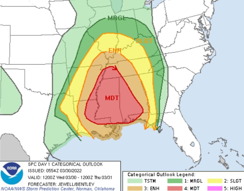
From the SPC:
Southern portions of the front/dryline will move much slower compared to farther north, resulting in a longer duration of boundary-layer moistening. A line of convection should become evident by 21Z from southwest MS into parts of southern LA, moving across MS and into north-central AL by about 03Z.
The subtle lift, combined with ample low-level moisture beneath an intense low-level jet, will favor tornadic supercells which may peak during the night. Effective SRH will remain high, averaging 400-500 m2/s2, with proper hodograph elongation in the mid and high levels. Given the long duration and slow eastward movement of this line of supercells, and the magnitude of the forecast hodographs, a few intense tornadoes could occur.
However, the threat will become limited late in the period due to decreasing instability to the east of about longitude 86W.
The good news is it still look slike the main concern is the wind and this isn’t looking like some kind of crazy Tornado Outbreak. But, there are a few important things to note:
- Those “Brief Spin-up Tornadoes” will be very quick to develop and, given the background wind speeds, are more likely to be stronger than they would be otherwise. So it will be easier for storms to produce EF-1 and EF-2 tornadoes when usually they would be EF-0 or EF-1 tornadoes
- While long-track tornadoes are not usually favored in squall line events, in this case they may be more likely given the amount of low-level shear and helicity.
- Combined those two means long track strong tornadoes are more likely today than they would be normally, in a similar setup.
But ‘more likely’ is relative. It isn’t that the chance you see a tornado is high. Nor that the chance you see a strong tornado is high. It is that it is higher than it normally would be.
The SPC Risk shows a 15-percent Tornado Risk. That is about seven-times higher than climatological average.

Looking at the pre-frontal environment on the Skew-T from the HRRR computer weather model, and things aren’t really lined up to get much in the way of pre-frontal convection.

While we can check many of the “boxes” we can’t get them all. And Forcing and DCAPE are the two we don’t hit historical averages that may limit convection. That is good news. Any storms that develop ahead of the line would be in a rather stout environment. If they could overcome the lack of forcing, you can see how many check marks we have up there.
On top of all of that, a reminder that the trajectory of storm motion will matter today. The more northerly storm motion is, the lower the tornado threat (generally speaking) and the more easterly storm motion is, the higher the tornado threat will be (generally).


And the angle of the line of storms will also matter as a more vertically stacked north-south line would cut off warmer inflow from the south to more storms that aren’t bowed out ahead of the main line. And a more angled line of storms allows access to the warm infow to more storms.
A more angled line of storms with more easterly trajectory = More low-level shear + access to warm inflow = more instability = higher tornado risk
With all of that being said, here is a look at the main concerns from the severe weather today…
MAIN CONCERNS
||| Between Wed 2p through 11p |||
Brief heavy rain
Localized flash flooding
Frequent lightning
Wind gusts up to 70mph (perhaps higher)
Small Hail
Multiple brief tornadoes
A few long-track tornado-producing storms
Tornadoes up to EF-3 in strength
During this (and previous) event, people have asked if there is a way to “‘help’ or ‘say thanks’ for all of the forecasting work I do. For the longest time I said, ‘nah! I just like doing this! You know, to help!’ But I was recently convinced that others want to ‘help’ in their own way, too.
And their way of helping, or simply saying ‘thank you’ is with a donation to the blog to help keep it running – or to help keep me running. So I’ve added this link. If you are one of those people, let me say thank you to YOU.
County-by-County Timeline
A quick reminder that this timeline doesn’t mean that the entire time it will be raining and storming. It is an attempt to give you the best window of opportunity for storms to be near you. A three to four hour window may only feature rain and storms for 30-45 minutes. But the goal is to highlight a window where the threat is higher than at other times.
Also, just because there is a potential for severe weather doesn’t mean that everyone is going to see the worst of the worst. For the moment, here is a look at the threats by general population:
During the highlighted times below
EVERYONE — Brief heavy rain, lightning, and wind gusts up to 50mph
MOST AREAS — Heavy rain, lightning, wind gusts up to 55mph
MANY PEOPLE — Heavy rain, localized flooding, wind gusts up to 65mph, small hail
SOME PLACES — Heavy rain, localized flooding, wind gusts exceeding 65mph, small hail,
FEW SPOTS — Heavy rain, localized flooding, wind gusts exceeding 70mph, small hail, a tornado up to EF-3 in strength
Louisiana
St. Helena Parish
Wednesday 1p-4p — Breezy. Isolated showers with few rumbles of thunder developing early, very few (if any) storms may be strong to severe before 4p. Main threats with any storm will be heavy rain, frequent lightning, gusty wind, small hail, and a tornado can not be ruled out.
Wednesday 4p-7p — Showers and storms likely, many strong with a handful severe. Main threats with stronger storms will be very heavy rain, frequent lightning, wind gusts up to 70mph, hail up to the size of quarters, and the potential for a tornado (up to EF3 in strength).
Wednesday 7p-10p — Storms ending. Turning cooler and breezy.
Tangipahoa Parish
Wednesday 1p-4p — Breezy. Isolated showers with few rumbles of thunder developing early, very few (if any) storms may be strong to severe before 4p. Main threats with any storm will be heavy rain, frequent lightning, gusty wind, small hail, and a tornado can not be ruled out.
Wednesday 4p-7p — Showers and storms likely, many strong with a handful severe. Main threats with stronger storms will be very heavy rain, frequent lightning, wind gusts up to 70mph, hail up to the size of quarters, and the potential for a tornado (up to EF3 in strength).
Wednesday 7p-10p — Storms ending. Turning cooler and breezy.
Washington Parish
Wednesday 1p-4p — Breezy. Isolated showers with few rumbles of thunder developing early, very few (if any) storms may be strong to severe before 4p. Main threats with any storm will be heavy rain, frequent lightning, gusty wind, small hail, and a tornado can not be ruled out.
Wednesday 4p-7p — Showers and storms likely, many strong with a handful severe. Main threats with stronger storms will be very heavy rain, frequent lightning, wind gusts up to 70mph, hail up to the size of quarters, and the potential for a tornado (up to EF3 in strength).
Wednesday 7p-10p — Storms ending. Turning cooler and breezy.
Livingston Parish
Wednesday 1p-4p — Breezy. Isolated showers with few rumbles of thunder developing early, very few (if any) storms may be strong to severe before 4p. Main threats with any storm will be heavy rain, frequent lightning, gusty wind, small hail, and a tornado can not be ruled out.
Wednesday 4p-7p — Showers and storms likely, many strong with a handful severe. Main threats with stronger storms will be very heavy rain, frequent lightning, wind gusts up to 70mph, hail up to the size of quarters, and the potential for a tornado (up to EF3 in strength).
Wednesday 7p-10p — Storms ending. Turning cooler and breezy.
St. Tammany Parish
Wednesday 1p-4p — Breezy. Isolated showers with few rumbles of thunder developing early, very few (if any) storms may be strong to severe before 4p. Main threats with any storm will be heavy rain, frequent lightning, gusty wind, small hail, and a tornado can not be ruled out.
Wednesday 4p-7p — Showers and storms likely, many strong with a handful severe. Main threats with stronger storms will be very heavy rain, frequent lightning, wind gusts up to 70mph, hail up to the size of quarters, and the potential for a tornado (up to EF3 in strength).
Wednesday 7p-10p — Storms ending. Turning cooler and breezy.
Mississippi
NEAR I-20
Copiah County
Wednesday 2p-6p — Showers and storms likely, many strong with a handful severe. Main threats with stronger storms will be very heavy rain, frequent lightning, wind gusts up to 70mph, hail up to the size of quarters, and the potential for a tornado (up to EF3 in strength).
Wednesday 6p-10p — Storms ending. Turning cooler and breezy.
Simpson County
Wednesday 2p-6p — Showers and storms likely, many strong with a handful severe. Main threats with stronger storms will be very heavy rain, frequent lightning, wind gusts up to 70mph, hail up to the size of quarters, and the potential for a tornado (up to EF3 in strength).
Wednesday 6p-10p — Storms ending. Turning cooler and breezy.
Smith County
Wednesday 2p-6p — Breezy. Isolated showers with few rumbles of thunder developing early, very few (if any) storms may be strong to severe before 6p. Main threats with any storm will be heavy rain, frequent lightning, gusty wind, small hail, and a tornado can not be ruled out.
Wednesday 6p-10p — Showers and storms likely, many strong with a handful severe. Main threats with stronger storms will be very heavy rain, frequent lightning, wind gusts up to 70mph, hail up to the size of quarters, and the potential for a tornado (up to EF3 in strength).
Wednesday 10p-Thursday 2a — Storms ending. Turning cooler and breezy.
Jasper County
Wednesday 2p-6p — Breezy. Isolated showers with few rumbles of thunder developing early, very few (if any) storms may be strong to severe before 6p. Main threats with any storm will be heavy rain, frequent lightning, gusty wind, small hail, and a tornado can not be ruled out.
Wednesday 6p-10p — Showers and storms likely, many strong with a handful severe. Main threats with stronger storms will be very heavy rain, frequent lightning, wind gusts up to 70mph, hail up to the size of quarters, and the potential for a tornado (up to EF3 in strength).
Wednesday 10p-Thursday 2a — Storms ending. Turning cooler and breezy.
Clarke County
Wednesday 2p-6p — Breezy. Isolated showers with few rumbles of thunder developing early, very few (if any) storms may be strong to severe before 6p. Main threats with any storm will be heavy rain, frequent lightning, gusty wind, small hail, and a tornado can not be ruled out.
Wednesday 6p-10p — Showers and storms likely, many strong with a handful severe. Main threats with stronger storms will be very heavy rain, frequent lightning, wind gusts up to 70mph, hail up to the size of quarters, and the potential for a tornado (up to EF3 in strength).
Wednesday 10p-Thursday 2a — Storms ending. Turning cooler and breezy.
HIGHWAY 84 CORRIDOR
Lincoln County
Wednesday 2p-6p — Showers and storms likely, many strong with a handful severe. Main threats with stronger storms will be very heavy rain, frequent lightning, wind gusts up to 70mph, hail up to the size of quarters, and the potential for a tornado (up to EF3 in strength).
Wednesday 6p-10p — Storms ending. Turning cooler and breezy.
Lawrence County
Wednesday 2p-6p — Showers and storms likely, many strong with a handful severe. Main threats with stronger storms will be very heavy rain, frequent lightning, wind gusts up to 70mph, hail up to the size of quarters, and the potential for a tornado (up to EF3 in strength).
Wednesday 6p-10p — Storms ending. Turning cooler and breezy.
Jeff Davis County
Wednesday 2p-6p — Breezy. Isolated showers with few rumbles of thunder developing early, very few (if any) storms may be strong to severe before 5p. Main threats with any storm will be heavy rain, frequent lightning, gusty wind, small hail, and a tornado can not be ruled out.
Wednesday 6p-10p — Showers and storms likely, many strong with a handful severe. Main threats with stronger storms will be very heavy rain, frequent lightning, wind gusts up to 70mph, hail up to the size of quarters, and the potential for a tornado (up to EF3 in strength).
Wednesday 10p-Thursday 2a — Storms ending. Turning cooler and breezy.
Covington County
Wednesday 2p-6p — Breezy. Isolated showers with few rumbles of thunder developing early, very few (if any) storms may be strong to severe before 6p. Main threats with any storm will be heavy rain, frequent lightning, gusty wind, small hail, and a tornado can not be ruled out.
Wednesday 6p-10p — Showers and storms likely, many strong with a handful severe. Main threats with stronger storms will be very heavy rain, frequent lightning, wind gusts up to 70mph, hail up to the size of quarters, and the potential for a tornado (up to EF3 in strength).
Wednesday 10p-Thursday 2a — Storms ending. Turning cooler and breezy.
Jones County
Wednesday 2p-6p — Breezy. Isolated showers with few rumbles of thunder developing early, very few (if any) storms may be strong to severe before 6p. Main threats with any storm will be heavy rain, frequent lightning, gusty wind, small hail, and a tornado can not be ruled out.
Wednesday 6p-10p — Showers and storms likely, many strong with a handful severe. Main threats with stronger storms will be very heavy rain, frequent lightning, wind gusts up to 70mph, hail up to the size of quarters, and the potential for a tornado (up to EF3 in strength).
Wednesday 10p-Thursday 2a — Storms ending. Turning cooler and breezy.
Wayne County
Wednesday 2p-6p — Breezy. Isolated showers with few rumbles of thunder developing early, very few (if any) storms may be strong to severe before 6p. Main threats with any storm will be heavy rain, frequent lightning, gusty wind, small hail, and a tornado can not be ruled out.
Wednesday 6p-10p — Showers and storms likely, many strong with a handful severe. Main threats with stronger storms will be very heavy rain, frequent lightning, wind gusts up to 70mph, hail up to the size of quarters, and the potential for a tornado (up to EF3 in strength).
Wednesday 10p-Thursday 2a — Storms ending. Turning cooler and breezy.
HIGHWAY 98 CORRIDOR
Pike County
Wednesday 2p-6p — Showers and storms likely, many strong with a handful severe. Main threats with stronger storms will be very heavy rain, frequent lightning, wind gusts up to 70mph, hail up to the size of quarters, and the potential for a tornado (up to EF3 in strength).
Wednesday 6p-10p — Storms ending. Turning cooler and breezy.
Walthall County
Wednesday 2p-6p — Showers and storms likely, many strong with a handful severe. Main threats with stronger storms will be very heavy rain, frequent lightning, wind gusts up to 70mph, hail up to the size of quarters, and the potential for a tornado (up to EF3 in strength).
Wednesday 6p-10p — Storms ending. Turning cooler and breezy.
Marion County
Wednesday 2p-6p — Breezy. Isolated showers with few rumbles of thunder developing early, very few (if any) storms may be strong to severe before 5p. Main threats with any storm will be heavy rain, frequent lightning, gusty wind, small hail, and a tornado can not be ruled out.
Wednesday 6p-10p — Showers and storms likely, many strong with a handful severe. Main threats with stronger storms will be very heavy rain, frequent lightning, wind gusts up to 70mph, hail up to the size of quarters, and the potential for a tornado (up to EF3 in strength).
Wednesday 10p-Thursday 2a — Storms ending. Turning cooler and breezy.
Lamar County
Wednesday 2p-6p — Breezy. Isolated showers with few rumbles of thunder developing early, very few (if any) storms may be strong to severe before 6p. Main threats with any storm will be heavy rain, frequent lightning, gusty wind, small hail, and a tornado can not be ruled out.
Wednesday 6p-10p — Showers and storms likely, many strong with a handful severe. Main threats with stronger storms will be very heavy rain, frequent lightning, wind gusts up to 70mph, hail up to the size of quarters, and the potential for a tornado (up to EF3 in strength).
Wednesday 10p-Thursday 2a — Storms ending. Turning cooler and breezy.
Forrest County
Wednesday 2p-6p — Breezy. Isolated showers with few rumbles of thunder developing early, very few (if any) storms may be strong to severe before 6p. Main threats with any storm will be heavy rain, frequent lightning, gusty wind, small hail, and a tornado can not be ruled out.
Wednesday 6p-10p — Showers and storms likely, many strong with a handful severe. Main threats with stronger storms will be very heavy rain, frequent lightning, wind gusts up to 70mph, hail up to the size of quarters, and the potential for a tornado (up to EF3 in strength).
Wednesday 10p-Thursday 2a — Storms ending. Turning cooler and breezy.
Perry County
Wednesday 2p-6p — Breezy. Isolated showers with few rumbles of thunder developing early, very few (if any) storms may be strong to severe before 6p. Main threats with any storm will be heavy rain, frequent lightning, gusty wind, small hail, and a tornado can not be ruled out.
Wednesday 6p-10p — Showers and storms likely, many strong with a handful severe. Main threats with stronger storms will be very heavy rain, frequent lightning, wind gusts up to 70mph, hail up to the size of quarters, and the potential for a tornado (up to EF3 in strength).
Wednesday 10p-Thursday 2a — Storms ending. Turning cooler and breezy.
Greene County
Wednesday 2p-6p — Breezy. Isolated showers with few rumbles of thunder developing early, very few (if any) storms may be strong to severe before 6p. Main threats with any storm will be heavy rain, frequent lightning, gusty wind, small hail, and a tornado can not be ruled out.
Wednesday 6p-10p — Showers and storms likely, many strong with a handful severe. Main threats with stronger storms will be very heavy rain, frequent lightning, wind gusts up to 70mph, hail up to the size of quarters, and the potential for a tornado (up to EF3 in strength).
Wednesday 10p-Thursday 2a — Storms ending. Turning cooler and breezy.
HIGHWAY 26 CORRIDOR
Pearl River County
Wednesday 2p-6p — Breezy. Isolated showers with few rumbles of thunder developing early, very few (if any) storms may be strong to severe before 5p. Main threats with any storm will be heavy rain, frequent lightning, gusty wind, small hail, and a tornado can not be ruled out.
Wednesday 6p-10p — Showers and storms likely, many strong with a handful severe. Main threats with stronger storms will be very heavy rain, frequent lightning, wind gusts up to 70mph, hail up to the size of quarters, and the potential for a tornado (up to EF3 in strength).
Wednesday 10p-Thursday 2a — Storms ending. Turning cooler and breezy.
Stone County
Wednesday 2p-6p — Breezy. Isolated showers with few rumbles of thunder developing early, very few (if any) storms may be strong to severe before 6p. Main threats with any storm will be heavy rain, frequent lightning, gusty wind, small hail, and a tornado can not be ruled out.
Wednesday 6p-10p — Showers and storms likely, many strong with a handful severe. Main threats with stronger storms will be very heavy rain, frequent lightning, wind gusts up to 70mph, hail up to the size of quarters, and the potential for a tornado (up to EF3 in strength).
Wednesday 10p-Thursday 2a — Storms ending. Turning cooler and breezy.
George County
Wednesday 2p-6p — Breezy. Isolated showers with few rumbles of thunder developing early, very few (if any) storms may be strong to severe before 6p. Main threats with any storm will be heavy rain, frequent lightning, gusty wind, small hail, and a tornado can not be ruled out.
Wednesday 6p-10p — Showers and storms likely, many strong with a handful severe. Main threats with stronger storms will be very heavy rain, frequent lightning, wind gusts up to 70mph, hail up to the size of quarters, and the potential for a tornado (up to EF3 in strength).
Wednesday 10p-Thursday 2a — Storms ending. Turning cooler and breezy.
COASTAL MISSISSIPPI
Jackson County
Wednesday 2p-6p — Breezy. Isolated showers with few rumbles of thunder developing early, very few (if any) storms may be strong to severe before 6p. Main threats with any storm will be heavy rain, frequent lightning, gusty wind, small hail, and a tornado can not be ruled out.
Wednesday 6p-10p — Showers and storms likely, many strong with a handful severe. Main threats with stronger storms will be very heavy rain, frequent lightning, wind gusts up to 70mph, hail up to the size of quarters, and the potential for a tornado (up to EF3 in strength).
Wednesday 10p-Thursday 2a — Storms ending. Turning cooler and breezy.
Harrison County
Wednesday 2p-6p — Breezy. Isolated showers with few rumbles of thunder developing early, very few (if any) storms may be strong to severe before 6p. Main threats with any storm will be heavy rain, frequent lightning, gusty wind, small hail, and a tornado can not be ruled out.
Wednesday 6p-10p — Showers and storms likely, many strong with a handful severe. Main threats with stronger storms will be very heavy rain, frequent lightning, wind gusts up to 70mph, hail up to the size of quarters, and the potential for a tornado (up to EF3 in strength).
Wednesday 10p-Thursday 2a — Storms ending. Turning cooler and breezy.
Hancock County
Wednesday 2p-6p — Breezy. Isolated showers with few rumbles of thunder developing early, very few (if any) storms may be strong to severe before 6p. Main threats with any storm will be heavy rain, frequent lightning, gusty wind, small hail, and a tornado can not be ruled out.
Wednesday 6p-10p — Showers and storms likely, many strong with a handful severe. Main threats with stronger storms will be very heavy rain, frequent lightning, wind gusts up to 70mph, hail up to the size of quarters, and the potential for a tornado (up to EF3 in strength).
Wednesday 10p-Thursday 2a — Storms ending. Turning cooler and breezy.
Alabama
Sumter County
Wednesday 4p-8p — Breezy. Isolated showers with few rumbles of thunder developing early, very few (if any) storms may be strong to severe before 7p. Main threats with any storm will be heavy rain, frequent lightning, gusty wind, small hail, and a tornado can not be ruled out.
Wednesday 8p-Thursday 2a — Showers and storms likely, many strong with a handful severe. Main threats with stronger storms will be very heavy rain, frequent lightning, wind gusts up to 70mph, hail up to the size of quarters, and the potential for a tornado (up to EF3 in strength).
Thursday 2a-6a — Storms ending. Turning cooler and breezy.
Choctaw County
Wednesday 4p-8p — Breezy. Isolated showers with few rumbles of thunder developing early, very few (if any) storms may be strong to severe before 7p. Main threats with any storm will be heavy rain, frequent lightning, gusty wind, small hail, and a tornado can not be ruled out.
Wednesday 8p-Thursday 2a — Showers and storms likely, many strong with a handful severe. Main threats with stronger storms will be very heavy rain, frequent lightning, wind gusts up to 70mph, hail up to the size of quarters, and the potential for a tornado (up to EF3 in strength).
Thursday 2a-6a — Storms ending. Turning cooler and breezy.
Washington County
Wednesday 4p-8p — Breezy. Isolated showers with few rumbles of thunder developing early, very few (if any) storms may be strong to severe before 7p. Main threats with any storm will be heavy rain, frequent lightning, gusty wind, small hail, and a tornado can not be ruled out.
Wednesday 8p-Thursday 2a — Showers and storms likely, many strong with a handful severe. Main threats with stronger storms will be very heavy rain, frequent lightning, wind gusts up to 70mph, hail up to the size of quarters, and the potential for a tornado (up to EF3 in strength).
Thursday 2a-6a — Storms ending. Turning cooler and breezy.


