Happy 4th y’all! As we get ready to celebrate, expect above-average temperatures potentially fueling hit-and-miss thunderstorms through the afternoon. A majority of the region will stay clear of storms, but don’t count on staying dry all day as a stray shower may move in to cool things down across the neighborhood.
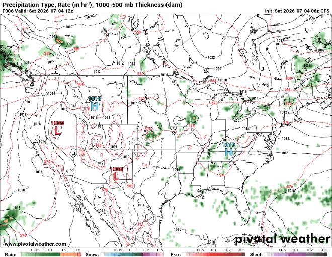
Our weekend precipitation forecast shows no organized systems impacting our area, just a few rounds of scattered thunderstorms popping up here and there. While most of the day stays dry, not everyone will see rain, but if one pops up over your celebration be ready for a quick downpour and some lightning.
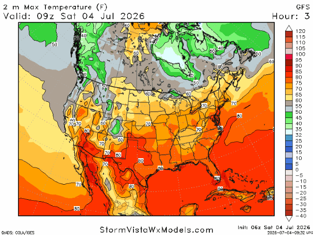
If you’re headed out to parades, the lake, or firing up the grill, make sure you’re prepared for the heat. Temperatures will climb into the low to mid 90s, with heat indices pushing closer to 100 degrees.
As we head into tomorrow morning, you may notice the sky looks a little hazy, and that’s thanks to tonight’s Fourth of July fireworks. Fireworks release tiny particles, known as particulate matter, into the air and since winds stay fairly light overnight, those particles don’t have much opportunity to disperse and instead linger close to the ground. This can reduce visibility and cause air quality to dip into the moderate range by early Sunday morning. As the sun comes up, daytime heating helps mix the atmosphere, allowing the smoke to disperse and the air quality to improve through the late morning and afternoon gradually.
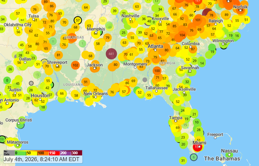
Looking at our current air quality, showing 2.5 micrometer particulate matter, we see near-average values across the board, except near Columbus, MS where PM values are dangerously high. The AQI (Air Quality Index) basically tells us how healthy it is to breathe based on how polluted our air is and how that will impact human health. The higher the AQI number, the greater the level of air pollution and the higher the potential health risk.
Tomorrow morning, one of the main pollutants we’ll be watching is PM2.5, or fine particulate matter. These are tiny particles that are about 30 times smaller than the width of a human hair and are produced by things like fireworks, wildfire smoke, and vehicle emissions. Because they’re so small, they can stay suspended in the air for hours and be inhaled deep into the lungs. For tomorrow, most people won’t notice a difference besides the hazy skies, but those with respiratory conditions may want to take it easy outdoors early in the day.
Stay safe and have a happy 4th!
3 Day Travel Forecast
AIRPORTS
KIAH / KHOU (Houston) – Clear and hot conditions with a low risk of delays.
KSHV (Shreveport) – Little to no delays due to weather.
KBTR (Baton Rouge) – Possible delays Sun/Mon due to afternoon T-storms
KMSY (New Orleans) – Clear and warm with few delays expected.
KJAN (Jackson) – Low risk of weather related delays.
KMOB (Mobile) – Low delay risk.
KBMH (Birmingham) – Hot with few delays expected.
KTLH (Tallahassee) – Possible delays from afternoon thunderstorms.
KATL (Atlanta) – Low delay risk due to storms.
Highways
I-10: Clear but hot, some afternoon thunderstorms heading into the afternoons.
I-20: Hot and sunny with isolated showers.
I-49: Warm weather with a slight risk of afternoon showers.
I-55 & I-59: Hot and clear weather expected with potential afternoon showers .
I-65: Expect warm weather with spotty afternoon showers.
I-75: Hot with the occasional afternoon thunderstorm, especially while travelling into Florida.
3-Day City Forecast
Houston, TX: Saturday (4th): Clear and hot throughout the day. High 97°F, low 80°F.
Sunday (5th): Hazy morning burning into a clear day. High 96°F, low 80°F.
Monday (6th): Warm and sunny with a chance of afternoon showers. High 93°F, low 79°F.
*HEAT ADVISORY UNTIL 7PM CT FOR HOUSTON, TX*
Shreveport, LA: Saturday (4th): Clear and hot throughout the day. High 94°F, low 77°F.
Sunday (5th): Hot with a hazy morning. High 94F, low 77°F.
Monday (6th): Warm with a chance of T-storms in the afternoon. High 94°F, low 77°F.
Baton Rouge, LA: Saturday (4th): Sunny with a slight chance for storms. High 95°F, low 77°F.
Sunday (5th): Hazy, hot with potential afternoon thunderstorms. High 92°F, low 76°F.
Monday (6th): Warm and sunny. High 91°F, low 76°F.
New Orleans, LA: Saturday (4th): Clear and hot throughout the day. High 93°F, low 80°F.
Sunday (5th): Hazy morning with afternoon storms. High 92°F, low 79°F.
Monday (6th): Warm with possible storms. High 91°F, low 80°F.
Jackson, MS: Saturday (4th): Hot with isolated showers. High 94°F, low 75°F.
Sunday (5th): Hazy morning with potential storms. High 91°F, low 74°F.
Monday (6th): Warm with showers. High 91°F, low 74°F.
*HEAT ADVISORY UNTIL 8PM CT FOR JACKSON, MS*
Birmingham, AL: Saturday (4th): Hot with slight storm chances. High 94°F, low 76°F.
Sunday (5th): Hazy morning with the chance for afternoon storms. High 93°F, low 75°F.
Monday (6th): Warm with potential afternoon T-storms. High 90°F, low 74°F.
*HEAT ADVISORY UNTIL 9PM CT FOR BIRMINGHAM, AL*
Mobile, AL: Saturday (4th): Mostly clear and hot throughout the day. High 95°F, low 77°F.
Sunday (5th): Hazy but mostly clear. High 93°F, low 77°F.
Monday (6th): Warm with a chance of storms. High 91°F, low 78°F.
Atlanta, GA: Saturday (4th): Hot with a slight chance of storms. High 96°F, low 77°F.
Sunday (5th): A hazy morning with isolated afternoon showers. High 95°F, low 75°F.
Monday (6th): Warm with afternoon showers. High 93°F, low 75°F.
*HEAT ADVISORY UNTIL 8PM CT FOR ATLANTA, GA*
Tallahassee, FL: Saturday (4th): Clear and hot throughout the day. High 97°F, low 76°F.
Sunday (5th): Hazy morning with T-storm chances. High 95°F, low 76°F.
Monday (6th): Warm with potential showers. High 93°F, low 76°F.


