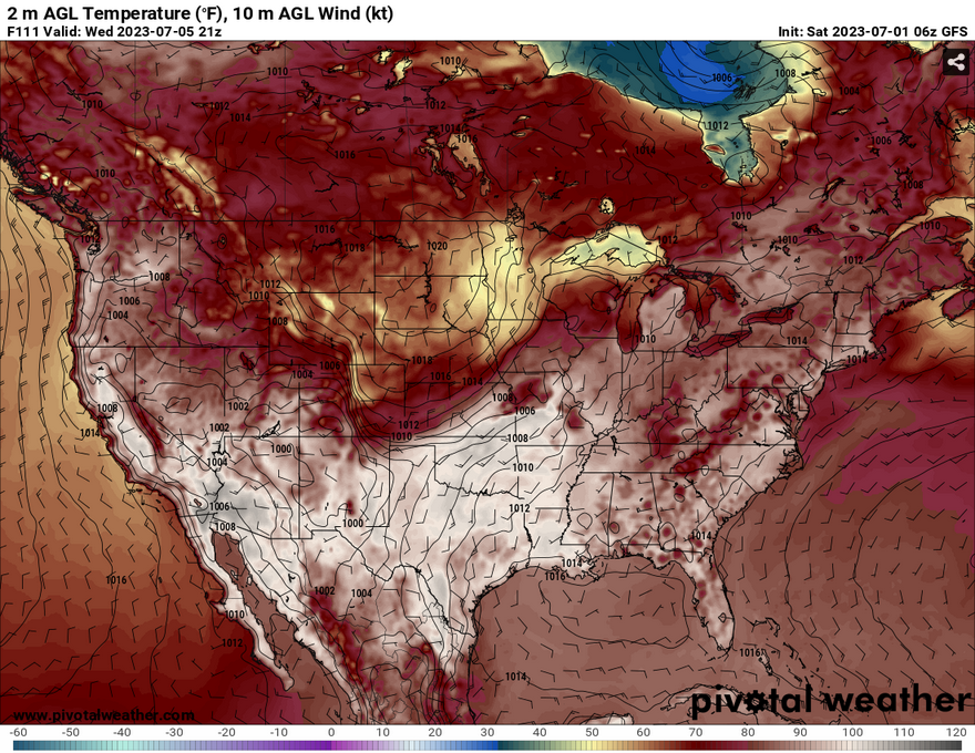
This weekend will still be very hot with heat indices reaching from 105-115 across the southeast, however, we’ll see a slight bit of relief into the week. The overbearing ridge that has been causing heat stress last week will dissolve and move east enough to reduce the heat index and allow for some rain especially closer to the end of the week.
Upper Levels and the Surface
The 500mb level shows the ridge slowly moving towards the Atlantic as a northern Rockies trough moves towards the Midwest US. The ridge will remain close to Florida while a series of troughs will develop and push through the northern plains into the Midwest. A strong ridge developing around California will build and park in the Southwest allowing for some western influence in the upper levels.
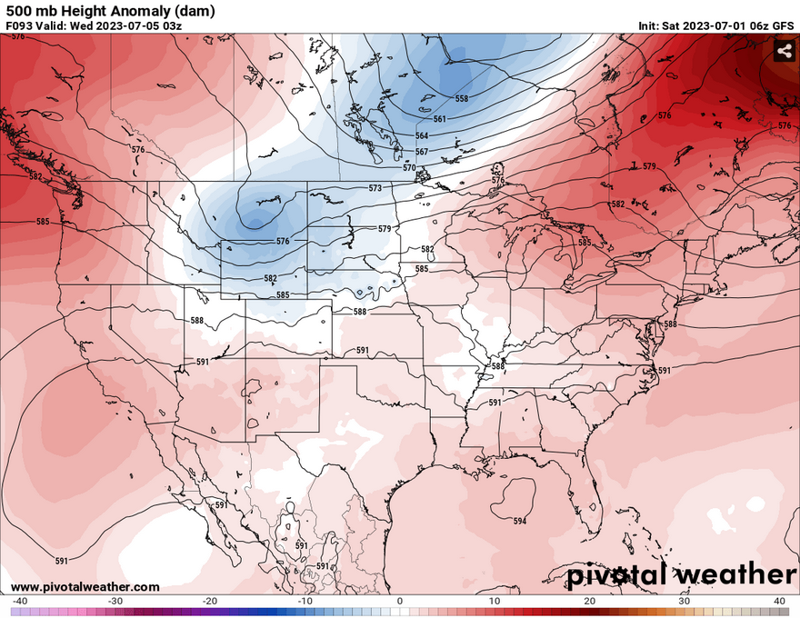
At the surface, as the ridge breaks down from Texas, another ridge will form in the Gulf of Mexico which will give much of Mississippi and Louisiana a southwestern influence. Thankfully, despite this influence, the dewpoints will be lower which will keep the heat index down for most of the week. A series of shortwaves will be the main influence for the rain chances for the next several days, however the strongest chance for rain will be closer to the weekend with a surface high nudging the low in the Great Lakes further north.
Diurnal Heat and Rain
This is the main story for next week is a mix of rain chances between the summertime heat. Starting Sunday, much of Mississippi will see some chance of rain with the first shortwave moving in during the late afternoon into the evening. Monday will also have scattered rain chances with the low pushing towards the Atlantic with remnants of the front causing more rain.
Tuesday and Wednesday will have more southern influenced rain chances with another set of shortwaves moving through the area. The higher chances of rain will be Thursday and Friday with a mess of storms caused by the northern plains high and a front forming over the southeast moving slowly across going into Friday.
Saturday will see mixed rain chances while Sunday will have a higher chance with more dense storms moving in with another front. The overall message for this week’s forecast is daily afternoon thunderstorm chances with a few chances for strong to severe. Temperatures will remain in the 90s for most of the week and heat indices will push towards the low 100s, so staying cool and hydrated is still a must for this part of the summer.
[wpcode id=”41179″]
Regional Day-to-Day Forecast
This Afternoon – Isolated showers and thunderstorms after 4pm. Sunny and hot, with a high near 100. Heat index values as high as 106. West southwest wind around 5 mph. Chance of precipitation is 20%.
Tonight – A slight chance of showers and thunderstorms between 9pm and 10pm. Partly cloudy, with a low around 77. West southwest wind around 5 mph becoming calm in the evening. Chance of precipitation is 20%.
Sunday – A 30 percent chance of showers and thunderstorms after 2pm. Mostly sunny and hot, with a high near 98. Heat index values as high as 109. Calm wind becoming west around 5 mph in the morning.
Sunday Night – A 30 percent chance of showers and thunderstorms, mainly before 8pm. Partly cloudy, with a low around 74. South wind around 5 mph becoming calm in the evening.
Monday – A 40 percent chance of showers and thunderstorms after 2pm. Mostly sunny, with a high near 96. Calm wind becoming south around 5 mph in the morning.
Monday Night – A 40 percent chance of showers and thunderstorms, mainly before 8pm. Mostly cloudy, with a low around 75. South southeast wind around 5 mph becoming calm in the evening.
Independence Day – Showers likely and possibly a thunderstorm between 8am and 2pm, then showers and thunderstorms likely after 2pm. Partly sunny, with a high near 95. Calm wind becoming southwest around 5 mph in the afternoon. Chance of precipitation is 60%.
Tuesday Night – Showers and thunderstorms likely, mainly before 8pm. Mostly cloudy, with a low around 75. Southwest wind around 5 mph becoming calm after midnight. Chance of precipitation is 60%.
Wednesday – Showers likely and possibly a thunderstorm between 8am and 2pm, then showers and thunderstorms likely after 2pm. Mostly sunny, with a high near 95. Calm wind becoming west southwest around 5 mph in the morning. Chance of precipitation is 70%.
Wednesday Night – Showers and thunderstorms likely before 2am, then a chance of showers. Mostly cloudy, with a low around 74. Chance of precipitation is 70%.
Thursday – Showers and possibly a thunderstorm. High near 94. Chance of precipitation is 80%.
Thursday Night – Showers and thunderstorms. Low around 73. Chance of precipitation is 80%.
Friday – Showers and possibly a thunderstorm. High near 91. Chance of precipitation is 80%.
[wpcode id=”41149″]


