For the next few days, we will have a cycle of hot weather helping to contribute to afternoon thunderstorms.
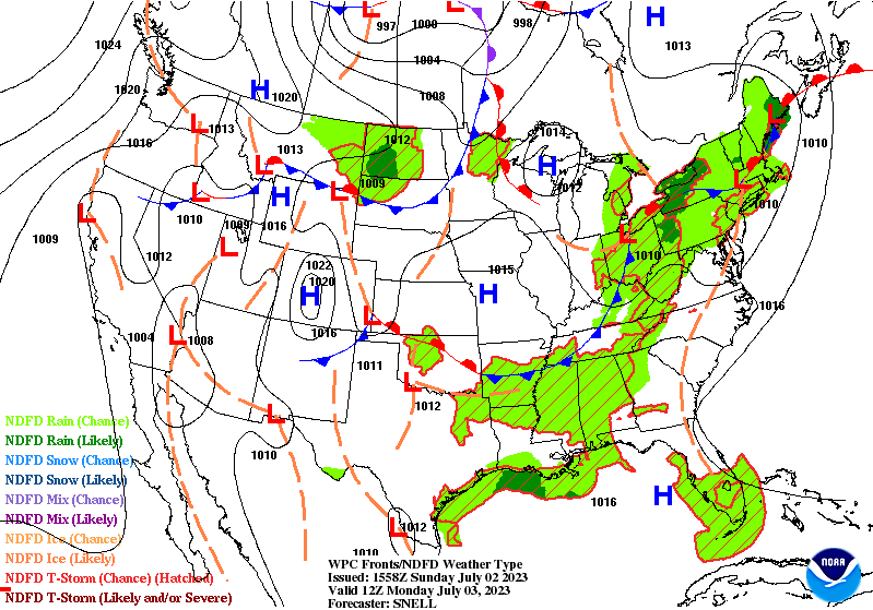
Looking at the surface, a Gulf high pressure system has established itself over the eastern Gulf near Florida. It will remain over us for the week moving slowly west. A high pressure system will grow from the Canadian Rockies and build over the northern Great Plains by the end of the week. Meanwhile, another high pressure system from the eastern plains will push east on a cold front for the next few days. A low pressure will begin to mature over the northeastern US while the high pressure will move into the Great Lakes near the weekend.
Rain Chances
Ending the weekend off, we’ll see a chance of thunderstorms coming from the coast in the late afternoon. Most of the severe weather will stay north overnight. Monday will also have some scattered thunderstorms forming from the southwest in the late afternoon.
Tuesday will see an organized line of storms with scattered rain chances closer to sunset. Wednesday and Thursday will both have scattered rain chances with diurnal mixing and squall lines forming in the evenings.
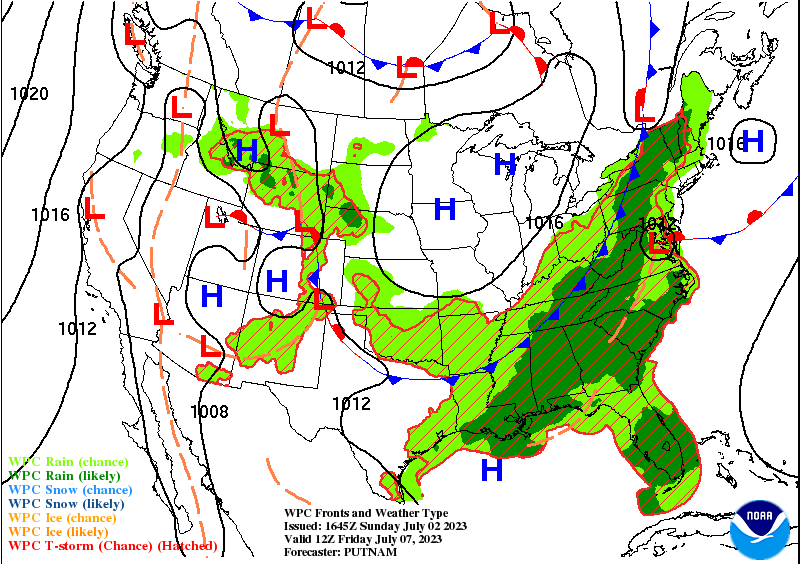
Overnight going into Friday, we’ll see a series of rain and thunderstorms with the cold front moving as close as it will get before being stalled by the Gulf ridge. A myriad of these storms will be possible throughout the day and will linger into Saturday.
Overnight into Sunday we’ll see more rain coming in throughout the day into Monday.
Temperatures and the Heat
Today until Wednesday temperatures will continue to be in the mid 90s for most of the Southeast. The heat index won’t be as oppressive as it was last week, but they will still reach to 100+. Due to the storms on Thursday and Friday, highs will be reduced to the low 90s. The weekend will see the return of temperatures in the 90s and upper 90s/low 100s heat indices. Safe to say a heat advisory isn’t out of the question for the next few days.
The Tropics
So far, the tropics have been fairly inactive. No waves have formed over Africa and nothing has formed near the Bahamas, so the NHC has not posted anything related to the Atlantic side of things. The Eastern Pacific near Mexico is currently dealing with Tropical Depression Adrian, however it’s moving further out to sea and will remain a depression for the next few days.
[wpcode id=”41179″]
This Afternoon – Scattered showers and thunderstorms in the mid afternoon. Partly sunny and hot, with a high in the upper 90s. Heat index values as high as 103. South southwest wind around 5 mph. Chance of precipitation is 40%.
Tonight – A 30 percent chance of showers and thunderstorms after sunset. Patchy fog in the early morning. Otherwise, mostly cloudy, with lows in the mid 70s. South southeast wind around 5 mph becoming calm in the evening.
Monday – A 50 percent chance of showers and thunderstorms, mainly after noon. Patchy fog in the early morning. Otherwise, mostly sunny, with a high in the mid 90s. Heat index values as high as 105. Calm wind becoming south around 5 mph in the afternoon. New rainfall amounts of less than a tenth of an inch, except higher amounts possible in thunderstorms.
Monday Night – A 20 percent chance of showers and thunderstorms before 1am. Patchy fog after 3am. Otherwise, mostly cloudy, with a low in the mid 70s. South southeast wind around 5 mph becoming calm in the evening.
Independence Day – A slight chance of showers, then showers and thunderstorms likely in the late morning. Patchy fog in the early morning. Otherwise, partly sunny, with a high in the mid 90s. Calm wind becoming west southwest around 5 mph in the morning. Chance of precipitation is 60%. New rainfall amounts of less than a tenth of an inch, except higher amounts possible in thunderstorms.
Tuesday Night – A 30 percent chance of showers and thunderstorms before 1am. Mostly cloudy, with a low in the mid 70s. South wind around 5 mph becoming calm in the evening.
Wednesday – Showers likely and possibly a thunderstorm before noon, then showers and thunderstorms likely. Partly sunny, with a high in the mid 90s. West southwest wind around 5 mph. Chance of precipitation is 70%.
Wednesday Night – A 40 percent chance of showers and thunderstorms. Mostly cloudy, with a low in the mid 70s. South wind around 5 mph becoming calm in the evening.
Thursday – Showers and possibly a thunderstorm before 1pm, then showers and thunderstorms after noon. Highs in the low 90s. West southwest wind around 5 mph becoming northwest in the afternoon. Chance of precipitation is 80%.
Thursday Night – A chance of showers and thunderstorms. Mostly cloudy, with a low in the low 70s. Chance of precipitation is 50%.
Friday – Showers and thunderstorms. Highs in the low 90s. Chance of precipitation is 80%.
Friday Night – A 30 percent chance of showers and thunderstorms. Mostly cloudy, with a low in the low 70s.
Saturday – Showers and thunderstorms likely. Mostly sunny, with a high in the low 90s. Chance of precipitation is 60%.
[wpcode id=”41149″]


