After many rounds of showers and thunderstorms this week, this weekend looks to be a bit more limited, but not without a chance of some stronger thunderstorms on Sunday. Next week looks to be a lot drier with a strong southwestern ridge residing over us.
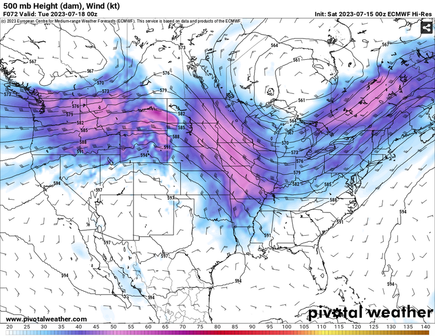
Looking at the upper levels, what happens after the weekend ends is a strong ridge forming over most of the Southwestern US. Between that are two troughs both in the Pacific Northwest and south of the Hudson Bay in Canada. Closer to home, a series of small shortwaves near the surface will push storms from TX/OK to central and south Mississippi both Saturday and Sunday. Afterwards, the southwestern ridge will dominate our atmosphere for most of next week with north and northwestern influence above and more western winds near the surface.
This Weekend
Like Nick mentioned in his forecast, this weekend’s forecast is a bit tricky since many of the computer models are not all in agreement with how much rain and where. It seems the rain for today will be more towards central Mississippi and may have a few isolated/scattered showers closer to the Pinebelt. Sunday, however, will be our biggest shot of rain. A more noble shortwave pushing across Texas will throw a small squall of storms towards west and central Louisiana and move southeast towards most of south Mississippi. Our main concern would be heavy rain (upwards of an inch within a couple of hours), straightline winds, and hail.

Outflow boundaries may form both from the sea breeze storms around the time the squall line arrives and ahead of the main line which would be cause for concern about the severe weather. These storms will likely hit around the mid-afternoon to early evening and continue until after sunset.
Next Week
Starting off Monday we may see a couple of showers closer to the coastline, but they will be limited due to the influence of the ridge out west. We will return to a very hot and humid pattern by mid-week with temperatures reaching the middle and upper 90s and heat indices in the mid 100s. Keep water and electrolytes on you at all times next week as we approach the middle of Summer, and it’s not going away any time. Heat advisories and even warnings will be possible during the week.
[wpcode id=”41179″]
Regional Day-to-Day Forecast
This Afternoon – Sunny, with a high near 96. Heat index values as high as 107. Rain possible in central MS. West wind around 5 mph.
Tonight – Mostly clear, with a low around 77. West wind around 5 mph becoming calm in the evening.
Sunday – Showers and thunderstorms likely in the afternoon moving southeast in the evening. Mostly sunny, with a high near 94. Heat index values as high as 107. West southwest wind 5 to 10 mph. Chance of precipitation is 70%. New rainfall amounts between three quarters and one inch possible.
Sunday Night – Scattered showers and thunderstorms possible after sunset. Mostly cloudy, then gradually becoming mostly clear, with a low around 74. West wind 5 to 10 mph becoming light and variable after midnight. Chance of precipitation is 30%.
Monday – A 40 percent chance of showers and thunderstorms in the afternoon. Sunny, with a high near 94. Heat index over 100 possible. West wind 5 to 10 mph.
Monday Night – A 30 percent chance of showers and thunderstorms before sunset. Partly cloudy, with a low around 74. South southwest wind around 5 mph.
Tuesday – Sunny and hot, with a high near 97. Heat index around 105. West wind 5 to 10 mph.
Tuesday Night – Mostly clear, with a low around 75. South southeast wind 5 to 10 mph becoming southwest after midnight.
Wednesday – Sunny and hot, with a high near 98. Heat index up to 110 possible. West southwest wind 5 to 10 mph becoming south southeast in the afternoon.
Wednesday Night – Mostly clear, with a low around 76.
Thursday – Sunny and hot, with a high near 98. Heat index up to 110 possible.
Thursday Night – Mostly clear, with a low around 77.
Friday – A 30 percent chance of showers and thunderstorms. Sunny and hot, with a high near 97. Heat index up to 110 possible.
[wpcode id=”41149″]


