It is still out there. It is still getting beat up by Hispaniola. And I wouldn’t worry too much about it. Given the available data, the overall pattern atmospherically, and the timeline laid out by the model data, Fred will have a difficult road ahead of it.
Truly, at this point, there is no reason, at this point, for anyone west of Mobile/Pensacola to do anything more than double-check your Hurricane Preparedness Kit, check around the house to make sure there are no loose branches in shrubs or dead branches in trees against your house, or able to fall on your house. Got water? Got food to last a few days? These are the things you should be thinking about right now.
But those are also things I would’ve (and did) told you to think about last week when there was nothing out there. This is just looking like a “big deal” at this time, and the likelihood that it does ‘blow up’ is also very low. Not zero. But very low.
I’ll talk more about the possibilities below, though.
From the NHC
Here is the latest from the National Hurricane Center

Tropical Storm Fred Discussion Number 9
NWS National Hurricane Center Miami FL
AL062021 500 PM EDT Wed Aug 11 2021During the past several hours, the center of Fred has moved inland over the Dominican Republic. The storm continues to produce an area of convection near and southeast of the center. However, the low-level circulation is losing some organization as it passes over mountainous terrain. There have been no observations near the center recently, so the initial intensity of 35 kt is based mainly on weakening from the previous over water intensity. The initial motion is a somewhat uncertain 290/13.
Some erratic motion is expected during the next 12 h or so as the center moves over the mountains of Hispaniola. After reaching the water, the cyclone is expected to moves west-northwestward on the south side of the subtropical ridge through about 60 h. After that, a northwestward motion is expected through the end of the forecast period as Fred moves toward a weakness in the ridge.
The track guidance becomes a bit divergent during this time, with the ECMWF, Canadian, and HWRF models showing a track near or over the Florida Peninsula, while the GFS, UKMET, and HMON models show the center passing south and west of the Florida Keys, followed by a more northward motion over the Gulf of Mexico. The new forecast track is between these extremes, and it has only minor adjustments from the previous NHC track. Fred is expected to weaken to a depression over Hispaniola during the next 12 h. Once back over water, the cyclone is expected to be in a moderate westerly shear environment through at least 60 h.
Due to that, and the uncertainty in how well organized the system will be after crossing Hispaniola, the intensity forecast shows only modest intensification during this time. After that time, the global models forecast that an upper-level trough over Florida will gradually move to the north, with an large upper-level anticyclone following near or to the southeast of Fred. How close this anticyclone gets to Fred will determine how much the shear decreases while the system is over the eastern Gulf of Mexico, and the global models are not in great agreement on this.
The GFS and Canadian keep the high far enough to the east to expose Fred to southwesterly upper-level winds, while the UKMET and ECMWF move it closer to the storm. The intensity forecast will show a slightly faster rate of strengthening after 72 h to match the guidance and the previous forecast. However, there is lower than normal confidence in this part of the intensity forecast.
KEY MESSAGES:
1. Tropical storm conditions are ongoing across portions of the Dominican Republic. Tropical storm conditions are possible in northern Haiti and the southeastern Bahamas this evening, and in portions of Cuba by tonight.
2. Through early Thursday morning, heavy rainfall could lead to flash, urban, and small stream flooding, along with possible rapid river rises and potential mudslides in the Dominican Republic.
3. There is a risk of wind and rainfall impacts elsewhere in portions of Hispaniola, the Bahamas, and Cuba during the next few days, although the forecast is more uncertain than usual since Fred is forecast to interact with Hispaniola through tonight.
4. There is an increasing risk of wind and rainfall impacts in Florida beginning Friday night or early Saturday in the Keys and spreading northward through portions of the Peninsula and the Panhandle Saturday through Monday. Beginning Friday, heavy rainfall could lead to areal, urban, and small stream flooding, and possible rapid river rises across southern Florida. Interests throughout Florida should monitor Fred’s progress and check updates to the forecast.FORECAST POSITIONS AND MAX WINDS
INIT 11/2100Z 18.9N 71.0W 35 KT 40 MPH…INLAND
12H 12/0600Z 19.8N 72.7W 30 KT 35 MPH…INLAND
24H 12/1800Z 20.9N 75.0W 30 KT 35 MPH…OVER WATER
36H 13/0600Z 21.9N 77.1W 35 KT 40 MPH
48H 13/1800Z 22.9N 79.2W 35 KT 40 MPH
60H 14/0600Z 23.9N 80.6W 40 KT 45 MPH
72H 14/1800Z 25.3N 82.0W 40 KT 45 MPH
96H 15/1800Z 28.5N 84.0W 50 KT 60 MPH
120H 16/1800Z 31.0N 85.0W 45 KT 50 MPH…INLAND
Model Data
Yes, there is data out there to support a stronger – much stronger – tropical system making landfall along the northern Gulf Coast. I won’t ignore that. But the likelihood of that data holding true – given all of the other available data at this point – is low.
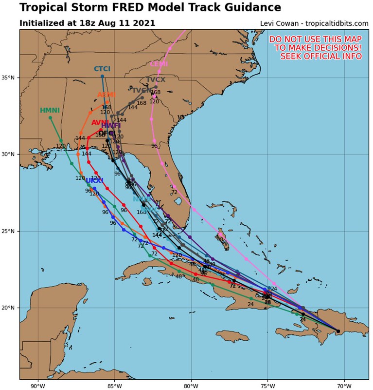
Here is a look at the forecast tracks from the available model data (left) and the forecast intensity data (right) courtesy of Levi Cowan’s site, Tropical Tidbits. Most of the tracks take Fred toward the Florida panhandle, with one making landfall near Mobile. And most of the intensity guidance keeps Fred as a Tropical Storm, a few keep it as a Tropical Depression.

So sure, I could show you this.

But for every model run like that, there is are two or three model runs like this…
And I could allow each of these to weigh evenly on your conscience, and given you the Black Sheep treatment singing, “You can go with this, or you can go with that”

But the truth is that the HWRF is one of the better tropical forecasting models we have for track. So it carries a bit more weight. The HMON is good. And it can do very well. But the HWRF is, historically, better.
And there is support for this from the GFS. Showing that it may get kicked a bit farther to the west, but for now, the west coast of Florida and the Florida panhandle are the most likely ‘winners’ of major impacts from Fred.
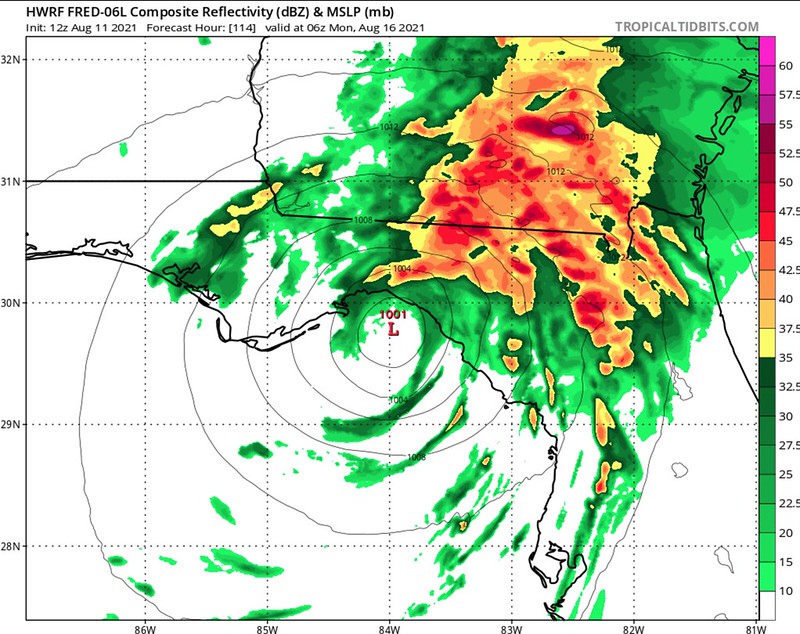
What about the Euro model? The “best” model, in the eyes of the Armchair Meteorological Quarterbacks has a take, too. But it says something different…

A bit east of the HWRF and GFS. And farther away from places west of Mobile/Pensacola.
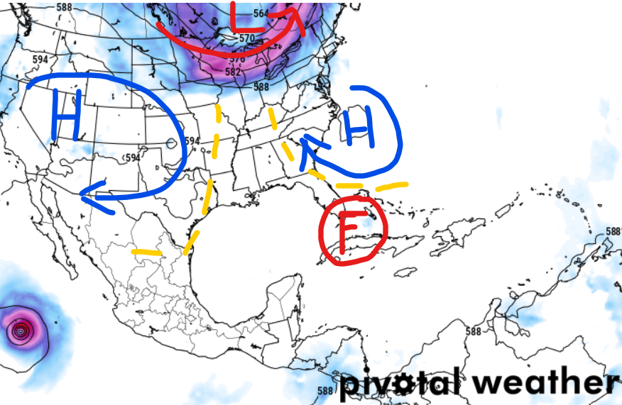
But you may ask, well why doesn’t it just follow that yellow arrow with the question mark? It could. Unlikely, but possible. If it were to do that, it would have to be very, very disorganized and weak, though. Because, recall that the more organized and the stronger a tropical system is, the more of a tendency it has to move toward the North Pole.
That is why waves more to the west, but once they form into hurricanes they tend to turn to the north as soon as they can. Sometimes they are blocked by a ridge of high pressure, but when they aren’t they move north ASAP.
… But, Katrina!
For reference, even Katrina did that.
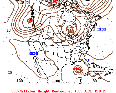
The map above shows Katrina in the central Gulf of Mexico. The difference with Katrina was that the ridge of high pressure that is noted above on the east coast of Florida was already in place a few days earlier across Alabama and Georgia (below). And it just needed to scoot out of the way.

In the case of Fred, the ridge of high pressure is already out of the way. So as soon as Fred moves by, it will turn north. Again, unless it is disorganized.
Who needs to start preparing?
Looking at the forecast track from the NHC and the rainfall totals from teh WPC, it looks like the largest impacts will be to the west coast of Florida and up into the panhandle. As well as parts of eastern Alabama and Georgia.

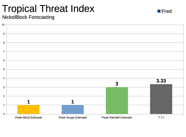
The main concerns look to be Tropical Storm-force wind (greater than 60mph), heavy rain (up to 9″) and storm surge (up to 4 feet).
That leaves us with a Tropical Threat index of 3.33. That is out of 10.
What does this mean for South Mississippi specifically?
Almost nothing, given the available data. Can things change? Yes. Will things change? Yes.
Will those changes mean South Mississippi is in the bullseye?
Possibly, but given the available data, the chances are low. Not zero, but low.
Again, this is a great time to double check your hurricane kit and prepare your home for a tropical system. Not because one is definitely coming, but because if one were to show up, then you are prepared. And just in case the forecast changes, iuf you prepare now, you won’t need to stress later.
And even if the forecast does change, we’ll be right here to be the first to let you know.

I know this was a long post just to say, “hang tight, no reason to worry if you live west of Mobile/Pensacola. But, hey, I never said I wasn’t verbose.


You aren’t talking to yourself! I read it all the way through and learned something.