Since so many of you guys appreciated my efforts earlier, I wanted to offer a quick update for everyone. Here is another long list of towns int eh area along with a forecast for each town with respect to Delta.
As I said before, doing this isn’t always precise. But I can try to be as accurate as possible. It is tough to nail down super specific stuff on a system that is 300-or-more miles across.
But I’ll give it a shot…
Right now
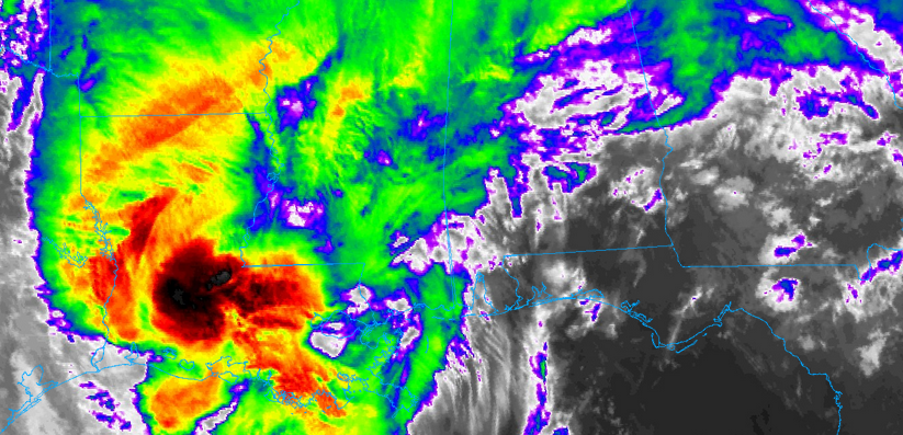
SUMMARY OF 700 PM CDT
LOCATION…30.0N 93.0W
ABOUT 25 MI…40 KM WSW OF JENNINGS LOUISIANA
MAXIMUM SUSTAINED WINDS…90 MPH…150 KM/H
PRESENT MOVEMENT…NNE OR 15 DEGREES AT 14 MPH…22 KM/H
MINIMUM CENTRAL PRESSURE…971 MB…28.67 INCHES
Forecast from the NHC

Northern areas
Quitman
Timeline
Friday Now – 10pm: Passing showers, Wind gusts up to 30mph as the first rainbands start to move through the area
Friday 10pm – Saturday 4am: Heavy rain at times, wind gusts up to 60mph and the potential for tropical tornadoes
Saturday 4am – Saturday 10am: Heavy rain at times, wind gusts up to 60mph and the potential for tropical tornadoes before 8am
Saturday 10am – 4pm: Passing tropical showers, wind gusts up to 40mph
Saturday 4pm – 10pm: Mostly cloudy, wind gusts up to 30mph, drying out
Expectations
– There will be some localized flooding, with water coming up in people’s yards and the creeks may rise a bit for a short period of time during some of the heavy rain within the rainbands.
– Power outages will be likely. Prepare to be without power for up to 6 hours. The combination of a constant breeze and higher gusts as well as some of the rain means trees are likely to come down. On top of that, tropical tornadoes will be possible within some of the rainbands.
– Based on the latest available data, this will not be a widespread catastrophic event for our area. But a some places will still see damage from gusty wind, downed trees and possible tornadoes.
Bay Springs
Timeline
Friday Now – 10pm: Passing showers, Wind gusts up to 40mph as the first rainbands start to move through the area
Friday 10pm – Saturday 4am: Heavy rain at times, wind gusts up to 60mph and the potential for tropical tornadoes
Saturday 4am – Saturday 10am: Heavy rain at times, wind gusts up to 60mph
Saturday 10am – 4pm: Passing tropical showers, wind gusts up to 40mph
Saturday 4pm – 10pm: Mostly cloudy, wind gusts up to 30mph, drying out
Expectations
– There will be some localized flooding, with water coming up in people’s yards and the creeks may rise a bit for a short period of time during some of the heavy rain within the rainbands.
– Power outages will be likely. Prepare to be without power for up to 6 hours. The combination of a constant breeze and higher gusts as well as some of the rain means trees are likely to come down. On top of that, tropical tornadoes will be possible within some of the rainbands.
– Based on the latest available data, this will not be a widespread catastrophic event for our area. But a some places will still see damage from gusty wind, downed trees and possible tornadoes.
Magee
Timeline
Friday Now – 10pm: Passing showers, Wind gusts up to 50mph as the first rainbands start to move through the area
Friday 10pm – Saturday 4am: Heavy rain at times, wind gusts up to 60mph and the potential for tropical tornadoes
Saturday 4am – Saturday 10am: Heavy rain at times, wind gusts up to 60mph before 6am
Saturday 10am – 4pm: Heavy rain at times, wind gusts up to 40mph
Saturday 4pm – 10pm: Mostly cloudy, wind gusts up to 30mph, drying out
Expectations
– There will be some localized flooding, with water coming up in people’s yards and the creeks may rise a bit for a short period of time during some of the heavy rain within the rainbands.
– Power outages will be likely. Prepare to be without power for up to 6 hours. The combination of a constant breeze and higher gusts as well as some of the rain means trees are likely to come down. On top of that, tropical tornadoes will be possible within some of the rainbands.
– Based on the latest available data, this will not be a widespread catastrophic event for our area. But a some places will still see damage from gusty wind, downed trees and possible tornadoes.
Near Highway 84
Monticello
Timeline
Friday Now – 10pm: Passing showers, Wind gusts up to 50mph as the first rainbands start to move through the area
Friday 10pm – Saturday 4am: Heavy rain at times, wind gusts up to 60mph and the potential for tropical tornadoes
Saturday 4am – Saturday 10am: Heavy rain at times, wind gusts up to 60mph before 6am
Saturday 10am – 4pm: Heavy rain at times, wind gusts up to 40mph
Saturday 4pm – 10pm: Mostly cloudy, wind gusts up to 30mph, drying out
Expectations
– There will be some localized flooding, with water coming up in people’s yards and the creeks may rise a bit for a short period of time during some of the heavy rain within the rainbands.
– Power outages will be likely. Prepare to be without power for up to 6 hours. The combination of a constant breeze and higher gusts as well as some of the rain means trees are likely to come down. On top of that, tropical tornadoes will be possible within some of the rainbands.
– Based on the latest available data, this will not be a widespread catastrophic event for our area. But a some places will still see damage from gusty wind, downed trees and possible tornadoes.
Collins
Timeline
Friday Now – 10pm: Passing showers, Wind gusts up to 40mph as the first rainbands start to move through the area
Friday 10pm – Saturday 4am: Heavy rain at times, wind gusts up to 60mph, and the potential for brief tropical tornadoes
Saturday 4am – Saturday 10am: Heavy rain at times, wind gusts up to 60mph and the potential for tropical tornadoes before 8am
Saturday 10am – 4pm: Heavy rain at times, wind gusts up to 40mph
Saturday 4pm – 10pm: Mostly cloudy, wind gusts up to 30mph, drying out
Expectations
– There will be some localized flooding, with water coming up in people’s yards and the creeks may rise a bit for a short period of time during some of the heavy rain within the rainbands.
– Power outages will be likely. Prepare to be without power for up to 6 hours. The combination of a constant breeze and higher gusts as well as some of the rain means trees are likely to come down. On top of that, tropical tornadoes will be possible within some of the rainbands.
– Based on the latest available data, this will not be a widespread catastrophic event for our area. But a some places will still see damage from gusty wind, downed trees and possible tornadoes.
Laurel
Timeline
Friday Now – 10pm: Passing showers, Wind gusts up to 30mph as the first rainbands start to move through the area
Friday 10pm – Saturday 4am: Heavy rain at times, wind gusts up to 60mph, and the potential for brief tropical tornadoes
Saturday 4am – Saturday 10am: Heavy rain at times, wind gusts up to 60mph and the potential for tropical tornadoes before 8am
Saturday 10am – 4pm: Passing tropical showers, wind gusts up to 40mph
Saturday 4pm – 10pm: Mostly cloudy, wind gusts up to 30mph, drying out
Expectations
– There will be some localized flooding, with water coming up in people’s yards and the creeks may rise a bit for a short period of time during some of the heavy rain within the rainbands.
– Power outages will be likely. Prepare to be without power for up to 6 hours. The combination of a constant breeze and higher gusts as well as some of the rain means trees are likely to come down. On top of that, tropical tornadoes will be possible within some of the rainbands.
– Based on the latest available data, this will not be a widespread catastrophic event for our area. But a some places will still see damage from gusty wind, downed trees and possible tornadoes.
Ellisville
Timeline
Friday Now – 10pm: Passing showers, Wind gusts up to 30mph as the first rainbands start to move through the area
Friday 10pm – Saturday 4am: Heavy rain at times, wind gusts up to 60mph, and the potential for brief tropical tornadoes
Saturday 4am – Saturday 10am: Heavy rain at times, wind gusts up to 60mph and the potential for tropical tornadoes before 8am
Saturday 10am – 4pm: Passing tropical showerss, wind gusts up to 30mph
Saturday 4pm – 10pm: Mostly cloudy, wind gusts up to 30mph, drying out
Expectations
– There will be some localized flooding, with water coming up in people’s yards and the creeks may rise a bit for a short period of time during some of the heavy rain within the rainbands.
– Power outages will be likely. Prepare to be without power for up to 6 hours. The combination of a constant breeze and higher gusts as well as some of the rain means trees are likely to come down. On top of that, tropical tornadoes will be possible within some of the rainbands.
– Based on the latest available data, this will not be a widespread catastrophic event for our area. But a some places will still see damage from gusty wind, downed trees and possible tornadoes.
Waynesboro
Timeline
Friday Now – 10pm: Passing showers, Wind gusts up to 30mph as the first rainbands start to move through the area
Friday 10pm – Saturday 4am: Heavy rain at times, wind gusts up to 60mph, and the potential for brief tropical tornadoes
Saturday 4am – Saturday 10am: Heavy rain at times, wind gusts up to 60mph and the potential for tropical tornadoes before 8am
Saturday 10am – 4pm: Passing tropical showers, wind gusts up to 40mph
Saturday 4pm – 10pm: Mostly cloudy, wind gusts up to 30mph, drying out
Expectations
– There will be some localized flooding, with water coming up in people’s yards and the creeks may rise a bit for a short period of time during some of the heavy rain within the rainbands.
– Power outages will be likely. Prepare to be without power for up to 6 hours. The combination of a constant breeze and higher gusts as well as some of the rain means trees are likely to come down. On top of that, tropical tornadoes will be possible within some of the rainbands.
– Based on the latest available data, this will not be a widespread catastrophic event for our area. But a some places will still see damage from gusty wind, downed trees and possible tornadoes.
Leakesville
Timeline
Friday Now – 10pm: Passing showers, Wind gusts up to 30mph as the first rainbands start to move through the area
Friday 10pm – Saturday 4am: Heavy rain at times, wind gusts up to 60mph, and the potential for tropical tornadoes
Saturday 4am – Saturday 10am: Heavy rain at times, wind gusts up to 60mph and the potential for tropical tornadoes
Saturday 10am – 4pm: Lingering showers, wind gusts up to 30mph
Saturday 4pm – 10pm: Mostly cloudy, wind gusts up to 30mph, drying out
Expectations
– There will be some localized flooding, with water coming up in people’s yards and the creeks may rise a bit for a short period of time during some of the heavy rain within the rainbands.
– Power outages will be likely. Prepare to be without power for up to 6 hours. The combination of a constant breeze and higher gusts as well as some of the rain means trees are likely to come down. On top of that, tropical tornadoes will be possible within some of the rainbands.
– Based on the latest available data, this will not be a widespread catastrophic event for our area. But a some places will still see damage from gusty wind, downed trees and possible tornadoes.
Along Highway 98
Beaumont / McLain
Timeline
Friday Now – 10pm: Passing showers, Wind gusts up to 40mph as the first rainbands start to move through the area
Friday 10pm – Saturday 4am: Heavy rain at times, wind gusts up to 60mph, and the potential for brief tropical tornadoes
Saturday 4am – Saturday 10am: Heavy rain at times, wind gusts up to 60mph and the potential for tropical tornadoes before 8am
Saturday 10am – 4pm: Heavy rain at times, wind gusts up to 30mph
Saturday 4pm – 10pm: Mostly cloudy, wind gusts up to 30mph, drying out
Expectations
– There will be some localized flooding, with water coming up in people’s yards and the creeks may rise a bit for a short period of time during some of the heavy rain within the rainbands.
– Power outages will be likely. Prepare to be without power for up to 6 hours. The combination of a constant breeze and higher gusts as well as some of the rain means trees are likely to come down. On top of that, tropical tornadoes will be possible within some of the rainbands.
– Based on the latest available data, this will not be a widespread catastrophic event for our area. But a some places will still see damage from gusty wind, downed trees and possible tornadoes.
New Augusta
Timeline
Friday Now – 10pm: Passing showers, Wind gusts up to 30mph as the first rainbands start to move through the area
Friday 10pm – Saturday 4am: Heavy rain at times, wind gusts up to 60mph, and the potential for brief tropical tornadoes
Saturday 4am – Saturday 10am: Heavy rain at times, wind gusts up to 60mph and the potential for tropical tornadoes
Saturday 10am – 4pm: Passing tropical showers, wind gusts up to 30mph
Saturday 4pm – 10pm: Mostly cloudy, wind gusts up to 30mph, drying out
Expectations
– There will be some localized flooding, with water coming up in people’s yards and the creeks may rise a bit for a short period of time during some of the heavy rain within the rainbands.
– Power outages will be likely. Prepare to be without power for up to 6 hours. The combination of a constant breeze and higher gusts as well as some of the rain means trees are likely to come down. On top of that, tropical tornadoes will be possible within some of the rainbands.
– Based on the latest available data, this will not be a widespread catastrophic event for our area. But a some places will still see damage from gusty wind, downed trees and possible tornadoes.
Petal
Timeline
Friday Now – 10pm: Passing showers, Wind gusts up to 30mph as the first rainbands start to move through the area
Friday 10pm – Saturday 4am: Heavy rain at times, wind gusts up to 60mph, and the potential for brief tropical tornadoes
Saturday 4am – Saturday 10am: Heavy rain at times, wind gusts up to 60mph and the potential for tropical tornadoes before 6am
Saturday 10am – 4pm: Lingering showers, wind gusts up to 30mph
Saturday 4pm – 10pm: Mostly cloudy, wind gusts up to 30mph, drying out
Expectations
– There will be some localized flooding, with water coming up in people’s yards and the creeks may rise a bit for a short period of time during some of the heavy rain within the rainbands.
– Power outages will be likely. Prepare to be without power for up to 6 hours. The combination of a constant breeze and higher gusts as well as some of the rain means trees are likely to come down. On top of that, tropical tornadoes will be possible within some of the rainbands.
– Based on the latest available data, this will not be a widespread catastrophic event for our area. But a some places will still see damage from gusty wind, downed trees and possible tornadoes.
Hattiesburg
Timeline
Friday Now – 10pm: Passing showers, Wind gusts up to 30mph as the first rainbands start to move through the area
Friday 10pm – Saturday 4am: Heavy rain at times, wind gusts up to 60mph, and the potential for brief tropical tornadoes
Saturday 4am – Saturday 10am: Heavy rain at times, wind gusts up to 60mph and the potential for tropical tornadoes before 6am
Saturday 10am – 4pm: Lingering showers, wind gusts up to 30mph
Saturday 4pm – 10pm: Mostly cloudy, wind gusts up to 30mph, drying out
Expectations
– There will be some localized flooding, with water coming up in people’s yards and the creeks may rise a bit for a short period of time during some of the heavy rain within the rainbands.
– Power outages will be likely. Prepare to be without power for up to 6 hours. The combination of a constant breeze and higher gusts as well as some of the rain means trees are likely to come down. On top of that, tropical tornadoes will be possible within some of the rainbands.
– Based on the latest available data, this will not be a widespread catastrophic event for our area. But a some places will still see damage from gusty wind, downed trees and possible tornadoes.
Columbia
Timeline
Friday Now – 10pm: Heavy rain at times, Wind gusts up to 50mph as the first rainbands start to move through the area
Friday 10pm – Saturday 4am: Heavy rain at times, wind gusts up to 60mph, and the potential for brief tropical tornadoes
Saturday 4am – Saturday 10am: Heavy rain at times, wind gusts up to 40mph
Saturday 10am – 4pm: Passing tropical showers, wind gusts up to 30mph
Saturday 4pm – 10pm: Mostly cloudy, wind gusts up to 30mph, drying out
Expectations
– There will be some localized flooding, with water coming up in people’s yards and the creeks may rise a bit for a short period of time during some of the heavy rain within the rainbands.
– Power outages will be likely. Prepare to be without power for up to 6 hours. The combination of a constant breeze and higher gusts as well as some of the rain means trees are likely to come down. On top of that, tropical tornadoes will be possible within some of the rainbands.
– Based on the latest available data, this will not be a widespread catastrophic event for our area. But a some places will still see damage from gusty wind, downed trees and possible tornadoes.
Purvis
Timeline
Friday Now – 10pm: Passing showers, Wind gusts up to 30mph as the first rainbands start to move through the area
Friday 10pm – Saturday 4am: Heavy rain at times, wind gusts up to 60mph, and the potential for brief tropical tornadoes
Saturday 4am – Saturday 10am: Heavy rain at times, wind gusts up to 60mph and the potential for tropical tornadoes before 6am
Saturday 10am – 4pm: Lingering showers, wind gusts up to 30mph
Saturday 4pm – 10pm: Mostly cloudy, wind gusts up to 30mph, drying out
Expectations
– There will be some localized flooding, with water coming up in people’s yards and the creeks may rise a bit for a short period of time during some of the heavy rain within the rainbands.
– Power outages will be likely. Prepare to be without power for up to 6 hours. The combination of a constant breeze and higher gusts as well as some of the rain means trees are likely to come down. On top of that, tropical tornadoes will be possible within some of the rainbands.
– Based on the latest available data, this will not be a widespread catastrophic event for our area. But a some places will still see damage from gusty wind, downed trees and possible tornadoes.
Lumberton
Timeline
Friday Now – 10pm: Passing showers, Wind gusts up to 30mph as the first rainbands start to move through the area
Friday 10pm – Saturday 4am: Heavy rain at times, wind gusts up to 60mph, and the potential for brief tropical tornadoes
Saturday 4am – Saturday 10am: Heavy rain at times, wind gusts up to 60mph and the potential for tropical tornadoes before 6am
Saturday 10am – 4pm: Lingering showers, wind gusts up to 30mph
Saturday 4pm – 10pm: Mostly cloudy, wind gusts up to 30mph, drying out
Expectations
– There will be some localized flooding, with water coming up in people’s yards and the creeks may rise a bit for a short period of time during some of the heavy rain within the rainbands.
– Power outages will be likely. Prepare to be without power for up to 6 hours. The combination of a constant breeze and higher gusts as well as some of the rain means trees are likely to come down. On top of that, tropical tornadoes will be possible within some of the rainbands.
– Based on the latest available data, this will not be a widespread catastrophic event for our area. But a some places will still see damage from gusty wind, downed trees and possible tornadoes.
The Highway 26 area
Poplarville
Timeline
Friday Now – 10pm: Passing showers, Wind gusts up to 40mph as the first rainbands start to move through the area
Friday 10pm – Saturday 4am: Heavy rain at times, wind gusts up to 60mph, and the potential for brief tropical tornadoes
Saturday 4am – Saturday 10am: Heavy rain at times, wind gusts up to 60mph and the potential for tropical tornadoes before 6am
Saturday 10am – 4pm: Lingering showers, wind gusts up to 30mph
Saturday 4pm – 10pm: Mostly cloudy, wind gusts up to 30mph, drying out
Expectations
– There will be some localized flooding, with water coming up in people’s yards and the creeks may rise a bit for a short period of time during some of the heavy rain within the rainbands.
– Power outages will be likely. Prepare to be without power for up to 12 hours. The combination of a constant breeze and higher gusts as well as some of the rain means trees are likely to come down. On top of that, tropical tornadoes will be possible within some of the rainbands.
– Based on the latest available data, this will not be a widespread catastrophic event for our area. But a some places will still see damage from gusty wind, downed trees and possible tornadoes.
Wiggins
Timeline
Friday Now – 10pm: Passing showers, Wind gusts up to 30mph as the first rainbands start to move through the area
Friday 10pm – Saturday 4am: Heavy rain at times, wind gusts up to 60mph, and the potential for brief tropical tornadoes
Saturday 4am – Saturday 10am: Heavy rain at times, wind gusts up to 60mph and the potential for tropical tornadoes before 6am
Saturday 10am – 4pm: Lingering showers, wind gusts up to 30mph
Saturday 4pm – 10pm: Mostly cloudy, wind gusts up to 30mph, drying out
Expectations
– There will be some localized flooding, with water coming up in people’s yards and the creeks may rise a bit for a short period of time during some of the heavy rain within the rainbands.
– Power outages will be likely. Prepare to be without power for up to 12 hours. The combination of a constant breeze and higher gusts as well as some of the rain means trees are likely to come down. On top of that, tropical tornadoes will be possible within some of the rainbands.
– Based on the latest available data, this will not be a widespread catastrophic event for our area. But a some places will still see damage from gusty wind, downed trees and possible tornadoes.
Lucedale
Timeline
Friday Now – 10pm: Passing showers, Wind gusts up to 40mph as the first rainbands start to move through the area
Friday 10pm – Saturday 4am: Heavy rain at times, wind gusts up to 60mph
Saturday 4am – Saturday 10am: Heavy rain at times, wind gusts up to 60mph and the potential for tropical tornadoes
Saturday 10am – 4pm: Lingering showers, wind gusts up to 30mph
Saturday 4pm – 10pm: Mostly cloudy, wind gusts up to 30mph, drying out
Expectations
– There will be some localized flooding, with water coming up in people’s yards and the creeks may rise a bit for a short period of time during some of the heavy rain within the rainbands.
– Power outages will be likely. Prepare to be without power for up to 12 hours. The combination of a constant breeze and higher gusts as well as some of the rain means trees are likely to come down. On top of that, tropical tornadoes will be possible within some of the rainbands.
– Based on the latest available data, this will not be a widespread catastrophic event for our area. But a some places will still see damage from gusty wind, downed trees and possible tornadoes.


