With hardly a drop of rain that we’ve seen in a while and burn bans all over South Mississippi, we’re not out of the clear quite yet. A brief chance of rain this weekend into next week unfortunately won’t bring any fire weather concerns any lower.
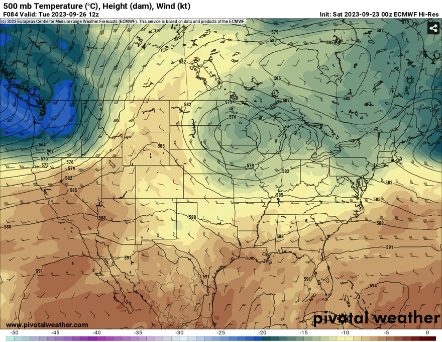
Looking at the upper levels, a trough moving from the Rockies will move into the plains and ultimately the upper midwest by the middle of the week. After tropical storm Ophelia moves off to the Atlantic, the trough will keep moving east along with it.

Towards the weekend, we see a much more polarizing shift in the upper levels. A fairly strong midwestern ridge will dominate the eastern half of the US while a strong trough waits out west to form over the Rockies. We know what the big ridge means, it’s going to be hot and dry again.
This Weekend
For the most part, Saturday and Sunday will be fairly dry with a few isolated showers towards the southwestern end of the state. Dewpoint temperatures will spike into the upper 60s to low 70s which is conducive to some possible rain over there. Temperatures will remain in the low 90s during the day and the mid to upper 60s at night.

Come Monday and possibly Tuesday, a shortwave from the Plains will move through the Deep South bringing a possible chance of rain. Dewpoints will spike into the upper 60s along the I-59 corridor which may bring some rain during the evening into the overnight hours.
Later in the week into the weekend, there may be a few spotty showers that develop in the afternoon, however most of these look to be closer to the coastline and isolated. With the big ridge forming over us again, drier conditions will prevail and reduce most shots for rain especially during the weekend. While fire weather conditions aren’t critical, burn bans are still in effect and probably won’t go away anytime soon.
[wpcode id=”41179″]
Regional Day-to-Day Forecast
This Afternoon – Sunny, with a high in the low 90s. East wind around 5 mph becoming north northeast.
Tonight – Mostly clear, with a low in the mid 60s. Northeast wind around 5 mph becoming calm in the evening.
Sunday – Mostly sunny, with a high in the mid 90s. Calm wind becoming southwest around 5 mph in the afternoon.
Sunday Night – Mostly cloudy, with a low in the low 70s. South southeast wind around 5 mph becoming calm in the evening.
Monday – A chance of showers, with thunderstorms also possible in the afternoon and evening. Partly sunny, with a high near 92. Calm wind becoming north around 5 mph in the afternoon. Chance of precipitation is 40%.
Monday Night – A 30 percent chance of showers and thunderstorms before midnight. Patchy fog after 5am. Otherwise, mostly cloudy, with a low in the upper 60s. North northeast wind around 5 mph becoming calm in the evening.
Tuesday – A slight chance of showers in the early morning, then a slight chance of showers and thunderstorms in the afternoon. Patchy fog in the early morning. Otherwise, mostly sunny, with a high in the mid 90s. Calm wind becoming east northeast around 5 mph in the afternoon. Chance of precipitation is 20%.
Tuesday Night – A slight chance of showers and thunderstorms. Partly cloudy, with a low in the upper 60s. East wind around 5 mph becoming calm in the evening. Chance of precipitation is 20%.
WednesdayA slight chance of showers, with thunderstorms also possible in the afternoon. Mostly sunny, with a high in the low 90s. Light east northeast wind increasing to 5 to 10 mph in the morning. Chance of precipitation is 20%.
Wednesday Night – A slight chance of showers and thunderstorms. Partly cloudy, with a low in the upper 60s. Chance of precipitation is 20%.
Thursday – A 20 percent chance of showers in the afternoon. Mostly sunny, with a high in the low 90s.
Thursday Night – Partly cloudy, with a low in the upper 60s.
Friday – Mostly sunny, with a high in the low 90s.
[wpcode id=”41149″]


