Mother Nature decided she wants the south to be soaked this week.
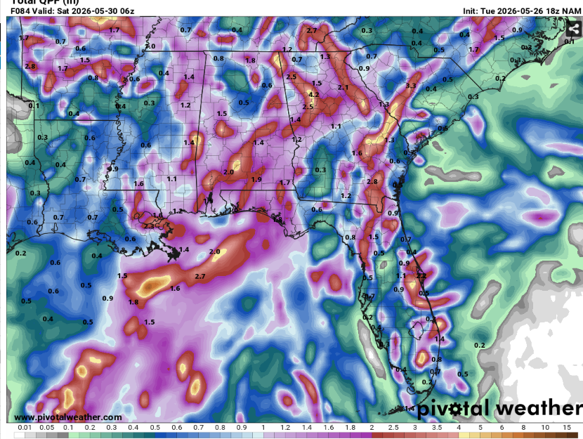
Widespread rainfall is expected to impact the area over the course of the next few days. This will work wonders for the drought but might tip the seesaw too much in the other direction and lead to flooding. Low lying areas and flood plains will likely be under water in some areas that receive the most rain (potentially over 5 inches in the next 4 days).
The severe weather threat will be low but not completely gone. A very brief and weak tornado may occur along with a wet microburst or two. Most location will only receive rain and lightning thankfully.
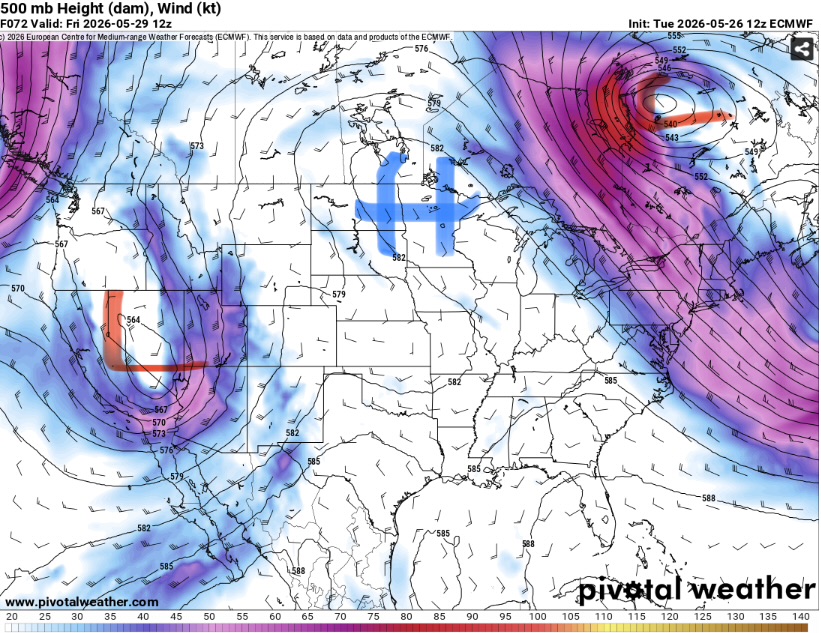
This is due to what’s known as a blocking pattern in the jet stream. These blocks can last for weeks and lock in a certain pattern for a given location (in our case widespread, weak thunderstorms). It is very difficult to forecast exactly when a blocking pattern will get unstuck, but it appears that it will stick around for at least another few days.
Highs will be cooler than average due to the clouds and storms but the humidity will keep the unpleasant feeling around. Winds will be very light and therefore provide little relief from the damp conditions.
Airport Forecasts
Houston (KIAH / KHOU)- There will likely be some storms moving through around sunrise, lingering till around noon. Short delays for lightning or downdrafts are possible .After this there should be no problems.
Shreveport (KSHV)- Widespread storms from late morning through mid afternoon capable of downbursts and frequent lightning. Flights before and after this should be unimpacted.
Baton Rouge (KBTR)- Morning flights will be fine. A cluster of storms will likely be in the area during the afternoon before diminishing by sunset. There may be a few delays for lightning and or microbursts.
New Orleans (KMSY)- Storms will be in the area from around noon till midnight. While they won’t be very strong, there will be enough of them to produce potentially numerous lightning delays.
Jackson (KJAN)- Shouldn’t be anything super strong but widespread afternoon and evening thunderstorms may cause a few lightning delays. Morning flights will likely be good.
Mobile (KMOB)- A chance of storms during the early afternoon but should be plenty of dry time and therefore good flying conditions. Most flights will be unimpacted unless they are traveling towards an area that has storms.
Birmingham (KBMH)- A stray storm is possible but the vast majority of the day should be calm weather with no issues.
Tallahassee (KTLH)- Minimal issues expected. There may be a window for an isolated storm or two in the late morning or early afternoon but should be mostly fine.
Atlanta (KATL)- Morning flights should be fine. There’s a chance there could be some lightning delays in the early to mid afternoon, but storms should be diminishing by evening.
Highways forecast
I-10 – Clear tonight through about mid-morning tomorrow. Scattered storms will develop from LA through AL bringing heavy rain and lightning. Should be clearing by evening
I-20 – Clear till around noon tomorrow. A spot shower or two over AL but nothing crazy. The main area to watch for storms and heavy rain will be from central LA to about Jackson during the afternoon hours.
I-49 – Clear till mid morning. A line of storms will move through northwest LA during the afternoon but should be east of the area by 4 or so.
I-55 and I-59 – Clear till noon. Thunderstorms will develop across the area and last into the evening with a threat for heavy rain and lightning. Storms will linger the longest in the southern MS vicinity.
I-65 – Not too bad. Isolated thunderstorms tomorrow afternoon but should be plenty of dry time.
I-75 – Scattered afternoon thunderstorms in GA but nothing too strong or severe.
City Forecasts
Houston, TX
Tonight- Mostly cloudy with lows in low to mid 70s. Thunderstorms likely as sunrise approaches.
Tomorrow- Mostly cloudy with widespread thunderstorms, mainly before 2pm or so. Highs in the upper 70s. Some localized flash flooding is also possible.
Thursday- Mostly cloudy with a high in the mid 80s. Chance of scattered thunderstorms.
Shreveport, LA
Tonight- Mostly cloudy with a low around 70. A chance of thunderstorms closer to sunrise.
Tomorrow- Chance of thunderstorms with highs in the mid 80s. Mostly cloudy and humid.
Thursday – Mostly cloudy with a high in the mid 80s. Scattered thunderstorms from midday through afternoon.
Baton Rouge, LA
Tonight- Mostly cloudy with a low in the lower 70s. Thunderstorms likely around sunset and the rapidly diminishing.
Tomorrow- Mostly cloudy with afternoon thunderstorms likely. High in the mid 80s. A flood threat is possible.
Thursday – Widespread showers and thunderstorms with highs in the low 80s. Mostly cloudy and very humid.
New Orleans, LA
Tonight- Thunderstorms gone by mid evening. Mostly cloudy afterwards with a low in the mid 70s.
Tomorrow- Widespread thunderstorms forming by mid day. Mostly cloudy with a high in the mid 80s. Some flooding is also possible.
Thursday – Numerous rain and thunderstorms with highs in the low to mid 80s. Mostly cloudy with a risk of flooding.
Jackson, MS
Tonight- Mostly cloudy with a low around 70. Thunderstorms dying out after sunset.
Tomorrow- Thunderstorms likely with highs in the mid 80s. Mostly cloudy and humid.
Thursday – Mostly cloudy with a high in the mid 80s. Numerous thunderstorms from midday through afternoon.
Birmingham, AL
Tonight- Mostly cloudy with a low in the upper 60s. Thunderstorms will be die out by mid evening.
Tomorrow- Increasing clouds with highs in the mid 80s. Scattered afternoon thunderstorms.
Thursday – Numerous thunderstorms with highs in the mid 80s. Increasing clouds and humid.
Mobile, AL
Tonight- Lows in the mid 70s and mostly cloudy. Isolated thunderstorms possible through late evening.
Tomorrow- Chance of scattered thunderstorms with highs in the mid 80s. Increasing clouds and humid.
Thursday – Widespread afternoon thunderstorms. Increasing Clouds with highs in the mid 80s.
Tallahassee, FL
Tonight- Thunderstorms dying off after sunset. Mostly cloudy with lows in the lower 70s
Tomorrow- Increasing clouds with a chance for afternoon thunderstorms. Highs in the upper 80s and humid.
Thursday – Widespread afternoon thunderstorms with highs in the mid to upper 80s. Increasing clouds and humid.
Atlanta, GA
Tonight- Mostly cloudy with a low in the upper 60s. Thunderstorms becoming less widespread by mid evening.
Tomorrow- Increasing clouds with highs in the low 80s. Scattered afternoon thunderstorms likely.
Thursday – Partly sunny with a high in the low to mid 80s. Isolated thunderstorms from midday through afternoon.


