Howdy!
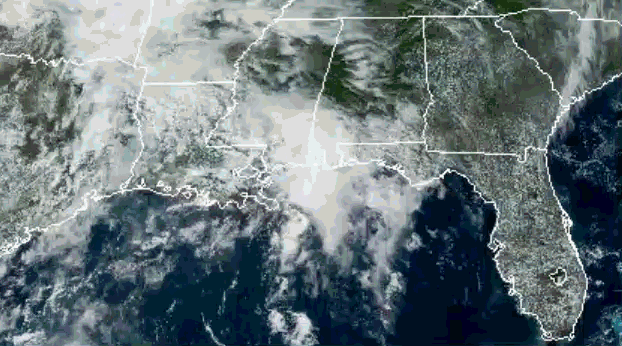
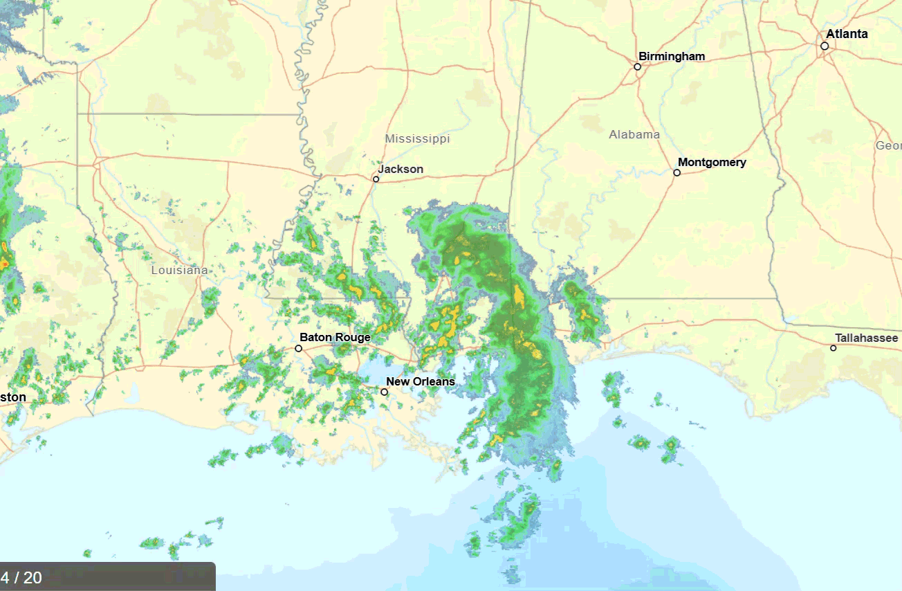
Happy Saturday! Looking out the window, we can see currently there are clouds covering Louisiana, most of Mississippi, and at the gulf coast of Alabama (Courtesy: NOAA). The radar (NWS) shows some moderate to heavier showers falling in the region, mostly on the coast of Mississippi out near Gulfport all the way to Hattiesburg. Alabama’s coast is also seeing lots of rain.
Temperatures currently range from low 70s all the way to the mid 80s. Dewpoints fall into the low 70s for much of the region, highest in New Orleans falling at 75.9. So pretty humid for everyone out there!
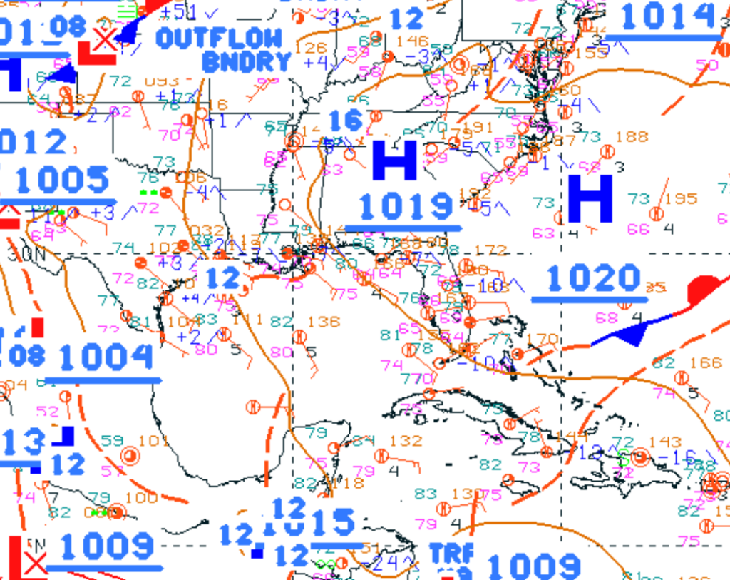
This weekend is playing out to be a wet one. As denoted below with the red dashed line off the coast of Louisiana, that tropical trough has closed in along the gulf coast, bringing with it lots of moisture to trigger those showers we are seeing.
We can see that moisture plume below in the Total Precipitable Water model heading into Louisiana and southern Mississippi. Largest chances of rain fall in these regions today, but all of our region is planning to see showers and thunderstorms at some point this weekend and going into Monday next week.

Broad subtropical ridging continues to be the pattern for the region going into next week. There is a weak trough-like pattern over Texas that could slightly influence any convection happening in Louisiana, but like I said it is pretty weak and will continue to be so for the next couple of days. Convection follows the flow of this pattern, heading east with time, greatest chances of rain for Alabama and Georgia being on Sunday and Monday.

As summer continues to peak its way through, this next couple of weeks will remain pretty warm with some afternoon chances of rain pretty much every day. Moisture will continue to flow into the region aiding those showers and thunderstorms.
3-DAY TRAVEL FORECAST
AIRPORTS
KIAH/KHOU (Houston) – Chances of rain are high today, falling at 80% mainly in the afternoon from 4-9pm. Rain is also possible in the early afternoon. Delays are possible due to any lightning that can occur. Wind gusts tomorrow are main concern with lightning that can occur mainly in the early afternoon, chance of rain falling at 40%. Monday no delays are expected as chance of rain is very minimal.
KSHV (Shreveport) – Shreveport will see showers and thunderstorms today in the afternoon, mainly after 1pm. The chance of precipitation is at 60%, chances continuing overnight. Minor delays are possible with any lightning. Same kind of pattern tomorrow as there was today, 70% chance of rain after 1pm, so delays possible with lightning. Monday, chances of rain decrease, so less delays are expected.
KBTR (Baton Rouge) – Some delays are possible due to lightning as showers and thunderstorms will occur throughout the day today, increasing into the afternoon/evening. Chance of precipitation is 80%. Tomorrow same story, greatest chance for showers and thunderstorms between 4-8pm. Chances of rain decrease on Monday to 30%, so delays are not expected.
KJAN (Jackson) – Showers and thunderstorms are possible throughout the entire day today, thunderstorm chances increasing into the afternoon. Chance of precipitation is 60%, continuing overnight, decreasing after 3am. Wind gusts will reach 20 mph overnight, so delays could occur due to lightning and winds tonight. Tomorrow is looking pretty similar, chances increasing. Monday is looking calmer, chance for delays not as great.
KMSY (New Orleans) – Showers and thunderstorms are possible throughout the day today, increasing in the afternoon. Same for tomorrow, least chance of rain is Monday (so delays are not expected). Minor delays are possible today/tomorrow with any lightning that can occur.
KMOB (Mobile) – Chances of precipitation today and tomorrow, today at 90% and tomorrow at 70%. Today is mainly showers and slight chance of thunderstorms, wind gusts up to 20 mph, so slight delays are possible for wind and rain concerns. That continues overnight into tomorrow, showers and thunderstorms possible in the afternoon, greatest after 4pm. Delays possible with any lightning. Monday there are no delays expected as chance of rain is minimal.
KATL (Atlanta) – Atlanta is not seeing much rain today or tomorrow, but chance of rain increases Sunday night into Monday. Monday has a chance of precipitation at 60%, showers in the morning, thunderstorm chances increasing in the early afternoon (around 2pm) into the evening. Greatest chance of flight delays is on Monday afternoon.
KTLH (Tallahassee) – Biggest concern for Tallahassee for the next few days is the heat! Highs fall in the low to mid 90s, so make sure to take care of yourself. Delays due to weather are not expected.
KBHM (Birmingham) – No chance of rain today, but overnight there will be. After 4am, chance of rain starts to increase into tomorrow, where it will rain pretty much all day. Chance of rain is 80% tomorrow, thunderstorms possible especially in the early afternoon. Rain continues overnight before 2 am. Same story Monday, chance of rain is 70%. Delays can be possible with lightning in the area.
HIGHWAYS
I-10 – Today and tomorrow be careful of the numerous showers and thunderstorms that will occur along the gulf coast of Mississippi, Alabama, and Florida. Chances of rain are possible every day, decreasing on Monday for the coast. Any flooding and winds are greatest concern for I-10.
I-20 – Early afternoon into the late afternoon today is greatest chance of rain for central Mississippi along I-20, tomorrow for Alabama, then Monday for Georgia. If traveling down this highway through the weekend, be aware of the line of showers and storms that will continue along this highway through the weekend.
I-49 – Today is the greatest risk of showers and thunderstorms along I-49, throughout the day into the evening. Make sure to be careful driving down this highway today as heavy rain can occur. Tomorrow and Monday are better travel days, but there will still be rain possible.
I-55 – Today and tomorrow have the greatest shower and thunderstorm chances, some producing heavy rainfall and winds. Main times of concern fall in the early afternoon into evening, but rain still possible in the morning. Greatest amount of rain will be along the coast into LA.
I-59 – Similar to I-20, early afternoon into the late afternoon today is greatest chance of rain for southern Mississippi along I-59, tomorrow for Alabama, then Monday for Georgia. If traveling down this highway through the weekend, be aware of the showers and storms that will continue along this highway through the weekend.
I-65 – Today and tomorrow be careful of the rain near the gulf coast of Alabama; rain amounts will increase throughout the day. For central Alabama, the greatest chance of rain is tomorrow in the afternoon, mainly after 1pm. Monday is looking like a better travel day for I-65.
I-75 – Today and tomorrow are good travel days for I-75! If you plan on traveling tomorrow night and Monday, make sure to be careful and drive safe as the rain makes its way through the region in the early afternoon (after 1pm).
CITY FORECASTS
Houston, TX
Today/Tonight – Strong chance of showers and thunderstorms, mainly between 4-9pm, some showers possible beforehand. Chance of rain is 80%, high reached 88 and a low of 77. Winds from the south around 5-10 mph. Rain amounts are as high as a half inch to three quarters of an inch.
Tomorrow – Showers and thunderstorms possible tomorrow mainly in the early afternoon. Chance of rain is 40%, partly sunny skies with a high of 89 and a low falling at 78. Winds will be stronger, gusts up to 20 mph.
Monday – A high at 90 degrees, low of 77 and mostly cloudy skies. Chances of rain are minimal, and winds are from the south at 10 mph.
Shreveport, LA
Today/Tonight – Showers and thunderstorms are possible in the afternoon (mainly after 1pm), falling at 60%. The high will reach around 86 and the low around 74, partly sunny skies with winds from the south/southeast at 5-10 mph.
Tomorrow – Same kind of pattern tomorrow as there was today, showers and thunderstorms in the afternoon after 1pm are possible, chance of precipitation is 70%. Skies will be mostly cloudy, high is 87 and low falling at 75. Winds will be from the south blowing a little harder at 10-15 mph.
Monday – Less chances for rain on Monday, skies will be partly sunny and the high will rise up to 90. The low will be around 75 and a southerly wind around 10 mph. Temps are rising up!
Baton Rouge, LA
Today/Tonight – Today will be pretty wet for Baton Rouge, chance of precipitation at 80% for the day. The high is 83, falling to 75 for the low. Chance of rain continues throughout the day until around 8pm tonight. Half an inch of rain is possible.
Tomorrow – Afternoon showers and thunderstorms are possible, chance of precipitation at 60% for before 4pm, then decreasing until around 8pm. The high will be near 88 and a low around 75, winds from the south at 5-10 mph.
Monday – Slight chance of rain on Monday at 30% for the afternoon. Cloudy skies with a high of 88 and a low near 74. Winds from the south at 5-10 mph becoming calmer overnight.
Jackson, MS
Today/Tonight – Today is looking pretty wet for Jackson, 60% chance of precipitation throughout the day. It will be overcast with a high near 84 and a low around 73. Rain will continue overnight. Wind gusts up to 20 mph are possible today, so be cautious of the rain and wind!
Tomorrow – Showers possible throughout the day, chance of thunderstorms increasing as the day progresses into the afternoon. Chance of precipitation is 70%, a high of 87 and a low near 73. Showers continue into the evening until around 1am.
Monday – Afternoon showers and thunderstorms are possible, but not as great of a chance as it has been for the past couple of days. The high will be near 88 and the low falling to 73. Winds will be calmer from the south.
New Orleans, LA
Today/Tonight – Today there is a 90% chance of rain, showers and thunderstorms increasing throughout the day. Half an inch of rain is possible. The high will be 85 and cool down to 77 for the low. Rain will continue throughout the night.
Tomorrow – Afternoon showers and thunderstorms are possible, mainly after 2pm increasing until 7pm. Chance of precipitation is 70%. The high is slightly warmer at 87, falling to 77 for the low. Winds will be from the south from 5-10 mph.
Monday – Slight chance of showers and thunderstorms in the afternoon, chance of 20%. The high will be around 87 and low of 77. Winds will be from the southeast at 5-10 mph.
Mobile, AL
Today/Tonight – Showers and thunderstorms possible throughout the day, mainly showers possible. Chance of rain is 90%, three quarters of an inch is possible, wind gusts up to 20 mph. The high will be around 83, low around 73. Chance of showers and thunderstorms continues overnight.
Tomorrow – Afternoon showers and thunderstorms possible, thunderstorms increasing after 4pm. Chance of precipitation is 70%, a high near 86 and a low of 73. Showers and thunderstorms continue, decreasing at 7pm. Winds calm overnight.
Monday – Chance of rain is minimal on Monday, high of 89 and low of 72. Winds shift from the southeast to the south around 5-10 mph, becoming calmer overnight.
Atlanta, GA
Today/Tonight – No rain today! The sun will be out, the high will be 88, cooling down to 69 for the low. Winds from the south around 5 mph, becoming calm tonight.
Tomorrow – An increase in clouds for tomorrow, bit still no chance for rain until Sunday night at 20% mainly after 2am. The high will be 85, cooling down to 71. Winds are calm.
Monday – Chance of precipitation is 60% on Monday, showers possible in the morning into the evening, chance for thunderstorms increasing into the afternoon. Winds are calm and are from the west. Precipitation continues Monday night into Tuesday.
Tallahassee, FL
Today/Tonight – A lot of sun today! And it will be hot, a high of 91 and southeast winds around 5-10 mph. Tonight it will cool down to 70, winds calming in the evening. It will be mostly cloudy tonight.
Tomorrow – A little more clouds tomorrow but not too much, hot again with a high of 93. Winds are from the south around 5-10 mph. The low will fall to 73, winds calming overnight.
Monday – Monday will be hot! A high near 96 with partly sunny skies, winds consistently from the south southeast around 5 mph. It will be a good day to go swimming, maybe go to the beach if you can. The low will fall around 76.
Birmingham, AL
Today/Tonight – Get out and enjoy today! Chance for rain does not occur until tonight, so partly sunny skies and a high near 88 for the day. Overnight we see the chance of rain increase going into tomorrow. Low will fall around 71.
Tomorrow – Chance for showers and thunderstorms throughout the day, starting early in the morning. Chance of precipitation is 80%, high of 83 and a low near 71. Up to a half inch of rain is possible, so make sure to carry that umbrella with you! Rain will continue overnight before 2am.
Monday – Chance of showers and thunderstorms is 70% throughout the day. Mainly in the morning/early afternoon. High on Monday will be near 84, falling to 70 for the low. Slight chance of showers continues Monday night.


