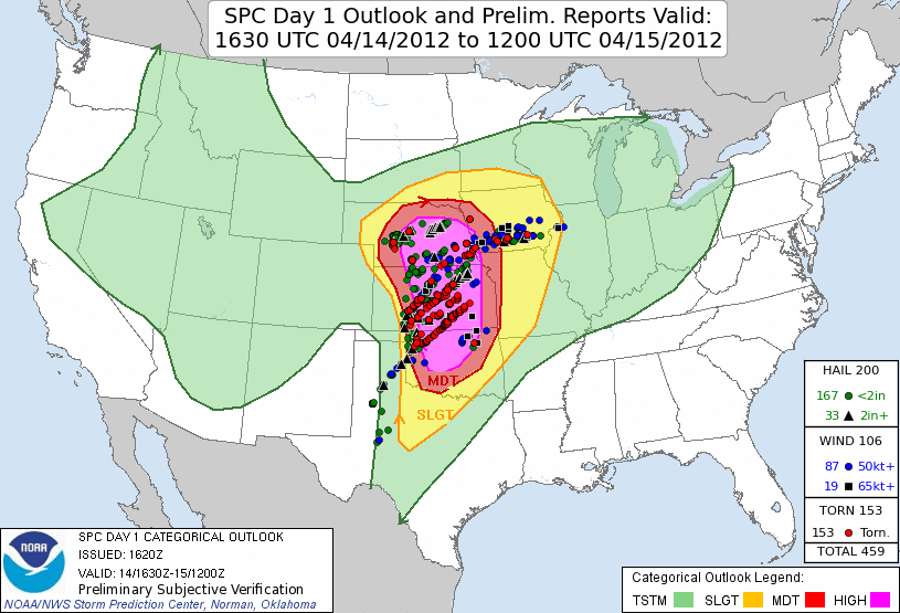
The April 14, 2012, Great Plains tornado outbreak was the largest tornado outbreak (by number of tornadoes) in recorded history in the American Great Plains. This tornado outbreak was embedded in a several day period of enhanced severe weather activity across the central United States. From 12z UTC (7am central time) on April 14 to 12z UTC on April 15, 86 tornadoes ravaged multiple states including Kansas, Oklahoma, Nebraska, and Iowa. Nine of these tornadoes were significant, with the strongest being an EF4 in central Kansas that was determined to have winds of 170 miles per hour. Amazingly, despite the wide footprint of the outbreak, only six deaths occurred, all from a single high-end EF3 that devastated Woodward, Oklahoma, around midnight as the event was winding down. One hundred and six areas of severe wind were also reported, with six of them being significant and the strongest being a measured gust of 97 miles per hour in Iowa. In addition, severe hail occurred in 202 places, with 33 measuring more than two inches and the largest, four and a half inches in diameter, fell in Kansas.
Known for being a textbook Great Plains dryline supercell tornado outbreak, that event’s synoptic conditions were as classic as they come.The event was very well forecast well in advance. The Storm Prediction Center (SPC) first issued a risk for severe weather in the region six days before the outbreak occurred. On the day three outlook, the SPC upgraded the threat to level four out of five (moderate risk). They included a corresponding 45 percent contour for severe weather within 25 miles of point, and they included a hatched region for a chance of significant severe weather. On the day before the event, the SPC issued an unprecedented high risk (level five out of five) with a resulting 30 percent tornado risk (along with a hatched region). To this day, this event is still the only time in history that the SPC has done this. On the morning of the event, the SPC further upgraded the tornado probabilities to an extremely rare 45 hatched, with the high risk extending from northern Nebraska to central Oklahoma. Multiple separate areas of tornado activity occurred with the main core extending from central Kansas to northern Oklahoma.
This case study will discuss the synoptic meteorology leading up to the event, and why severe weather occurred when and where it did. It will discuss why some areas were more favorable than others for severe weather, and how this compared to expectations. Lastly, it will compare the April 14, 2012, Great Plains tornado outbreak to the similar and equally historic March 13, 1990, Great Plains tornado outbreak and the April 26, 1991, Great Plains tornado outbreak. These three events share similar background conditions, end results, and geographic locations.
The two days preceding April 14, 2012, both contained convective severe weather on the Great Plains. On April 12, the forecast from the SPC called for supercells across western Kansas.The main hazards expected were large hail and tornadoes (with a chance at significant tornadoes) as storms initiated along a dryline. Due to strong capping and a lack of lift, with the main upper level trough and associated forcing being well to the west, storms were unable to develop in the areas with the highest environmental parameters for severe storms. Instead, storms initiated to the north in northwest Kansas and southwest Nebraska along the triple point and warm front. Due to much lower amounts of instability and the aforementioned lack of lift, these storms struggled to become robust, with the main impacts being several reports of large hail on some mainly elevated storms north of the surface warm front. A brief tornado was reported as a storm favorably interacted with the boundary, but it was very weak and little damage was reported. The main threat area for significant severe weather (as outlined by the SPC) was almost entirely storm free.
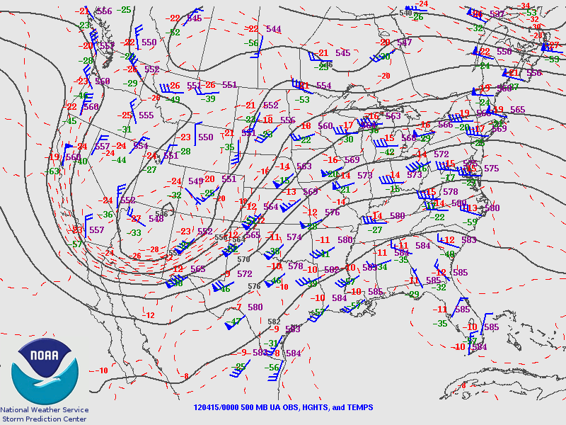
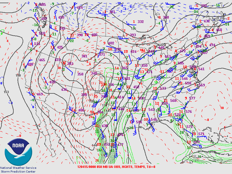
By 12Z on April 13, the main trough at 300 mb was located over the southwestern United States and off the coast into the Pacific Ocean. A jet streak featuring winds in excess of 140 knots was centered along the southern California coastline, while an area of enhanced flow (around 80 knots) was nosing into the central High Plains. At 500mb, a closed low was located off the Oregon coast, and therefore the main trough (and the weather maker for the April 14, 2012, Great Plains tornado outbreak) was still well to the west of the plains. A lead shortwave was traversing the central plains with a belt of enhanced 40- to 60-knot flow stretching from the panhandles to southeast South Dakota. The southerly low-level jet (850mb) axis was centered from Iowa to central Texas, with a distinct wind shift stretching from Nebraska to southwest Oklahoma, where the winds sharply veered from a southerly component to west-north-westerly. The magnitude of the jet was quite strong, with speeds in the 30 to 60 knot range. At the surface, a low was positioned over central Nebraska, with a warm front draped southeast down to Missouri. A cold front extended to the southwest through the panhandles and with a dryline extending from Kansas into Central Texas. The warm sector environment was classified by upper 50s and low 60s dew points, while areas north and west of the front had temperatures in the 40s and dew points in the upper 30s to low 40s. As the day progressed, the low occluded off to the north and weakened, while the dryline retreated to the west– allowing rapid warm air advection to commence. Surface temperatures quickly warmed into the 70s across the southern plains, and dew points slowly increased as well. The SPC outlined a risk of significant severe weather including large hail and strong tornadoes centered on Oklahoma.
Around 4pm central time, several supercells developed along the dryline in southwest Oklahoma moving east-northeast. These storms started off as mainly hail producers, given the relatively lackluster low-level shear and large temperature-to-dew point spread promoting an outflow-dominant structure. By 7pm on April 13 (0Z on April 14), the 500 millibar trough had advanced eastward with a low amplitude area of 50 to 60 knots of flow directly over the Oklahoma warm sector. At the anvil level (300 millibars), a neutrally tilted trough with its axis over California was spreading seasonably strong flow of 70 to 80 knots over the central plains. As sundown approached and the low-level jet ramped up to around 30 to 35 knots, these supercells became tornadic. Twelve tornadoes were confirmed across Oklahoma during the evening, however all of them were weak (EF0 or EF1). This was mainly due to adequate but not extreme shear profiles and destructive storm interactions. It was just a warmup for what was to come the next day.
The forecast on the evening before April 14 called for an extremely volatile environment but cast uncertainty on exactly where storms would occur. Moisture was forecast to surge northward, potentially all the way to the Nebraska-South Dakota border given the expected low-level response. The expected shear profiles were upper echelon, which would cause any storm that did initiate to rotate and produce strong to potentially violent tornadoes. The complex of storms over Oklahoma were supposed to push east and dissipate, allowing most of the central and southern plains to completely destabilize, as the sky would be clear and moisture (60s dew points) would surge north. The SPC mentioned, “THIS ENVIRONMENT IS EXPECTED TO BE CONDUCIVE FOR A SIGNIFICANT OUTBREAK OF SEVERE STORMS,” and issued a 45 hatched tornado risk for central Nebraska and a 30 hatched tornado risk for northern Oklahoma and southern Kansas. The SPC reasoned that the shear was better along the warm front and that there may be less storm coverage further south until the cold front initiated a squall line at sunset which would mainly bring a damaging wind threat. Regardless, the set of high end parameters forecast from southern Oklahoma to northern Nebraska, if realized, would allow any discrete updraft to rotate and produce large hail and potentially intense tornadoes.
At 300 mb 12Z UTC on April 14, the front edge of a large trough was spreading 50 to 90 knots of southwest flow stretching from New Mexico to South Dakota. The main jet streak with an embedded 140 knot speed maximum was still off to the west and had yet to round the base of the trough. Strong divergence was noted across the plains. In the mid levels (500mb), broad southwest flow of around 50 knots was beginning to impact the High Plains. At 700mb, several shortwaves were noted traversing the base of the Rockies in southern New Mexico. An expansive southerly 35 to 60 knot low-level jet was noted from south Texas to southern Kansas. This jet would continue to strengthen throughout the day and would help provide moisture and lift to the target region. A decaying convective complex was noted on radar across northeast Oklahoma and southeast Kansas as a result of the previous day’s convection. These storms would continue to push off to the east and dissipate by late morning. Lee cyclogenesis was underway by mid morning in eastern Colorado, classic placement for a big Great Plains tornado outbreak. Strong (15 to 20 knot) south-south easterly surface flow was in place from Texas to the Kansas-Nebraska border. To the north, a warm front extended across Nebraska and Iowa with easterly winds and low clouds on the cool side. A dryline was draped from Western Kansas down through the eastern Texas Panhandle with a cold front to the west along the Texas-New Mexico border. The warm sector was characterized by temperatures of around 70 and dew points in the low to mid 60s. Temperatures would slowly climb to the mid 70s across the warm sector, with dew points inching upward as well by the time storms would initiate. Overall, the environment was extremely favorable for significant severe weather, including long-track intense tornadoes, and was only growing more volatile as the day wore on.
The sky across the risk area was only slightly clear when the sun rose on April 14. Due to all of the low level moisture and warm air advection, not much sunlight was able to penetrate to the earth’s surface. The area receiving the most sun during the morning was across western Kansas into southwest Nebraska. Due to the boost in solar heating, and corresponding jump in instability, storms quickly fired in this area before the environment was primed. The forecast (from the SPC and others), had originally expected central Nebraska to be the area with the highest risk for tornadoes (and other hazards), since the best shear was likely to be located along the warm front and that storm coverage would be most certain in this area. Although lots of storms were forecast (potentially too many to allow individual cells to organize), shear profiles were so high and hodographs so curved that storms were supposed to stay relatively discrete. Since storms fired too early, before the trough had fully arrived, shear profiles and associated hodographs were less impressive, allowing storms to become outflow-dominant and therefore significantly lowering the threat for tornadoes. As such, the SPC lowered tornado probabilities to 30 hatched in Nebraska, while raising them to 45 hatched for the Oklahoma and Kansas dryline on the 20Z outlook update. The storms that initiated over western Kansas, despite forming at around 10:30 am, were still able to produce severe weather. Numerous reports of large hail (including some in excess of two inches) occurred across western Kansas into Nebraska. Additional storms fired along the warm front in northeast Nebraska at around the same time. The storms that had originally formed in Kansas began producing several weak tornadoes across northern portions of that state and into Nebraska. Even though the parameters these storms were ingesting were much lower than what was supposed to occur later in the day, they still supported rotating cells; but the conditions were not favorable for significant tornadoes. As these storms grew more upscale, all of eastern Nebraska became contaminated with convection and cloud cover. This prevented any additional supercells from developing across the primary threat area. As the day wore on, these storms began to encounter more favorable thermodynamic profiles and increasing wind shear as they trained along the warm front. This allowed two significant tornadoes to develop, one in eastern Nebraska and the other in western Iowa. Both of these tornadoes were rated EF2 and although significant damage did occur, thankfully there were no fatalities. Behind these storms in central Nebraska, the air mass recovered enough for new supercells to initiate. These new storms produced several tornadoes and multiple instances of large hail, until the loss of daytime heating and a surging frontal boundary caused upscale growth into an outflow-dominant cluster.
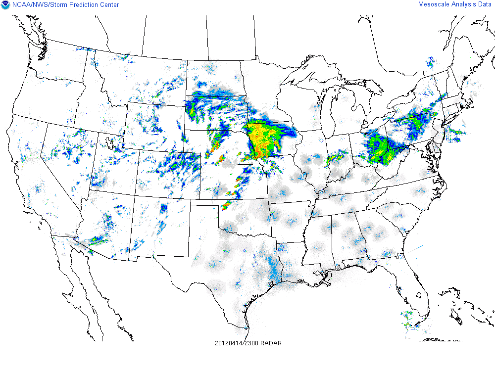
Across the open sector from central Kansas into central Oklahoma, the atmosphere was rapidly priming. When the day began, the main uncertainty was how many storms would initiate and when, as a strong cap and only weak lift was supposed to be in place until after 0z. By early afternoon, areas of clearing were evident on visible satellite imagery ahead of the dryline across southwestern Kansas, through western Oklahoma, and into the Texas Panhandle. During the mid-afternoon, as bubbling cumulus clouds percolated along the dryline, it became clear that storms would indeed develop before sunset and that an extremely dangerous situation was about to occur. Several supercells initiated along the dryline near Dodge City, Kansas, by 19:30Z. Due to the extreme shear (300-500 effective storm relative helicity) and increasing instability (around 1500 mixed layer CAPE), these storms organized into supercells extremely rapidly and began producing tornadoes. These tornadoes did little to no damage initially, as the environment had still not yet peaked and since there were not many structures in the path in this part of rural Kansas. As evening progressed, the low-level jet began to ramp up and the supercells strengthened. Just after 5:30pm, the lone violent tornado of the outbreak would touch down and track north of Salina. This intense tornado would track over 50 miles across mostly open terrain and stay on the ground for over an hour. It would completely level several farmsteads, earning it an EF4 rating with peak estimated winds of 170 miles per hour. Shortly after this tornado lifted, the parent supercell would weaken and eventually dissipate as it ran into the stable air created by the complex over Nebraska. Further south, in southern Kansas and northern Oklahoma, several cyclic supercells tracked for over 100 miles producing numerous tornadoes. One of these tornadoes would strike the east side of Wichita, causing severe damage and earning it an EF3 rating.
As the trough fully ejected into the plains, forcing for ascent drastically increased causing significant convective coverage along the retreating dryline in northwest Oklahoma. This allowed a supercell to form ahead of the developing squall line. Given a low-level jet exceeding 50 knots, this storm was able to quickly produce a strong tornado as it entered Woodward, Oklahoma. Tragically, this EF3 would claim six lives, as it ripped through town after midnight when many people had let their guards down. Miraculously, this was the only fatal tornado of the outbreak. Shortly after this tornado dissipated, the squall line completely enveloped the supercell, ending the tornado threat. This line would trudge east across Kansas and Oklahoma, slowly losing steam as instability diminished, bringing an end to the historic outbreak.
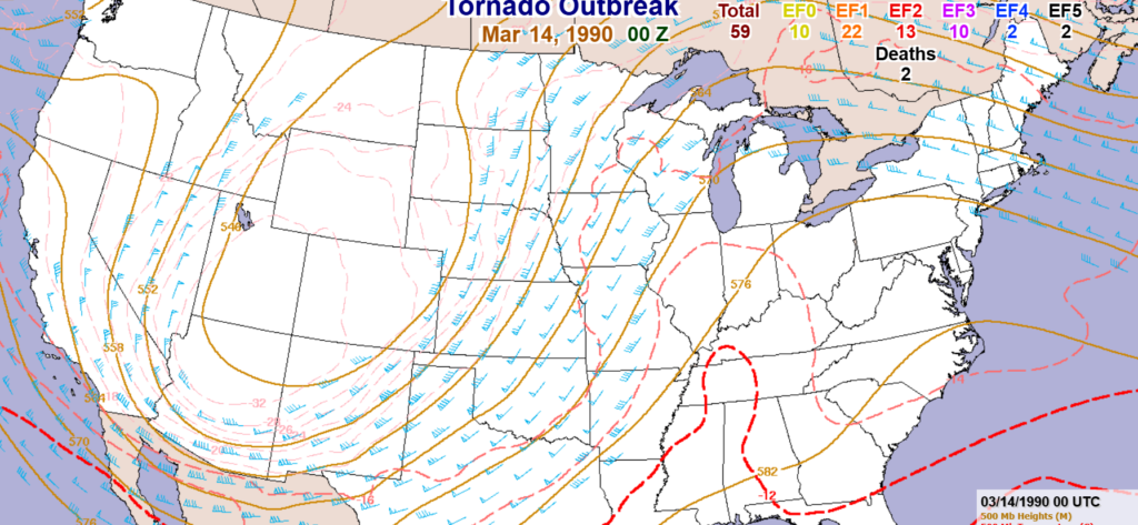
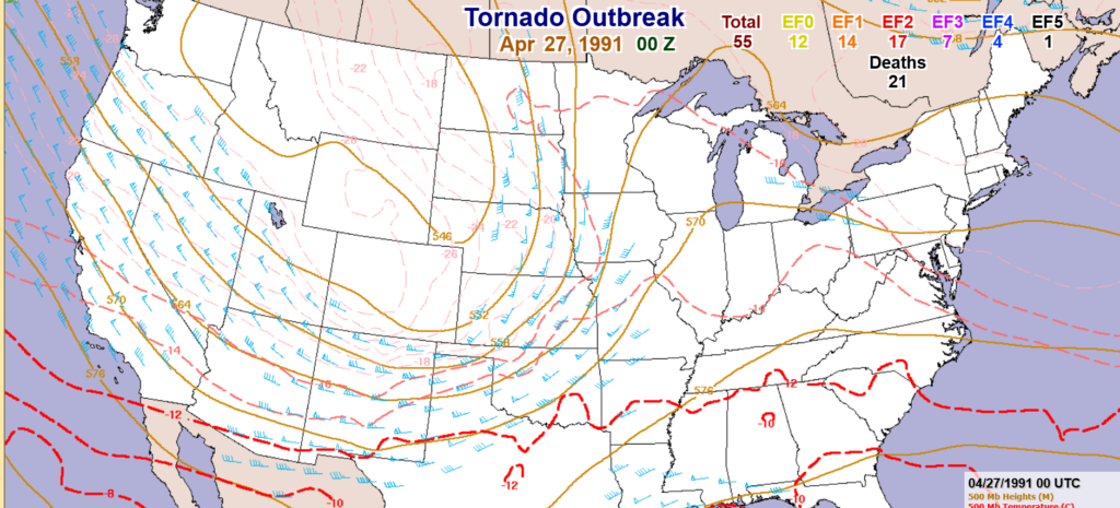
The two events with the most similarities to April 14, 2012, were the tornado outbreaks of March 13, 1990, and April 26, 1991. Both of these events were driven by a large, high amplitude trough ejecting across the plains, perfectly timed with daytime heating. Interestingly enough, both the April 14, 2012, outbreak and the March 13, 1990, troughs were produced by positively tilted troughs, dispelling the notion that it is only possible to get large severe weather outbreaks with negatively tilted troughs. The March 13, 1990, and the April 26, 1991, outbreaks both featured significantly fewer tornadoes with 59 and 55, respectively. Of note however, was the fact that those outbreaks featured more significant to violent tornadoes. The March 13, 1990, outbreak had 27 significant tornadoes, including two F4s and two F5s, while the April 26, 1991, tornado had 29 significant tornadoes, with four F4s and one F5. This could be because the parameters on these days supported more steady-state mesocyclones, making for longer track (and therefore fewer) tornadoes, and that the tornadoes on April 14, 2012, were lucky enough to hit high end damage indicators when they were at peak strength. All of these outbreaks featured tornadoes from Nebraska and Iowa, down into southern Kansas and Oklahoma. Another defining characteristic of the tornadoes in all of these outbreaks was their highly visible nature. This is likely because there was ample streamwise vorticity and the initiating boundary was a dryline (a classic staple of Great Plains tornado outbreaks), which kept storms as discrete, classic supercells.
Overall, the April 14, 2012, tornado outbreak was a historic example of a textbook Great Plains tornado outbreak. Eighty five tornadoes were confirmed in Iowa, Nebraska, Kansas and Oklahoma. It was a very well forecast synoptically high-end event, as the SPC accurately picked out a chance of severe weather across the region six days out. The outbreak was driven by strong southwest flow in the target area with cyclogenesis in eastern Colorado allowing for a strong low level response. Supercells spawned most of the tornadoes making them highly visible. This type of synoptic setup has proven many times in the past that it is conducive for significant Great Plains tornado outbreaks.