Howdy!
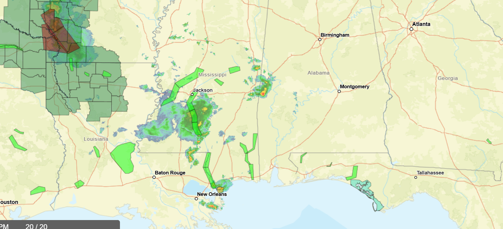
Looking out the window, we can see there are some clouds over the region and rain occurring in central/southern Mississippi especially in areas near and south of Jackson, MS. Flood watches and warnings are in effect in Louisiana, Florida and Mississippi currently.
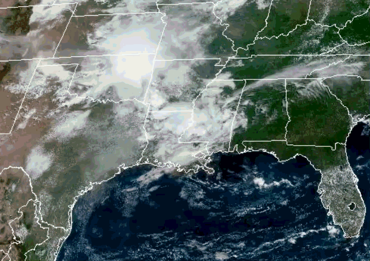
Temperatures currently (at 1:00 CST) range from the upper 70s to the upper 80s, places where rain is seen are cooler. Dewpoints in the low to upper 70s, keeping conditions on the humid side.
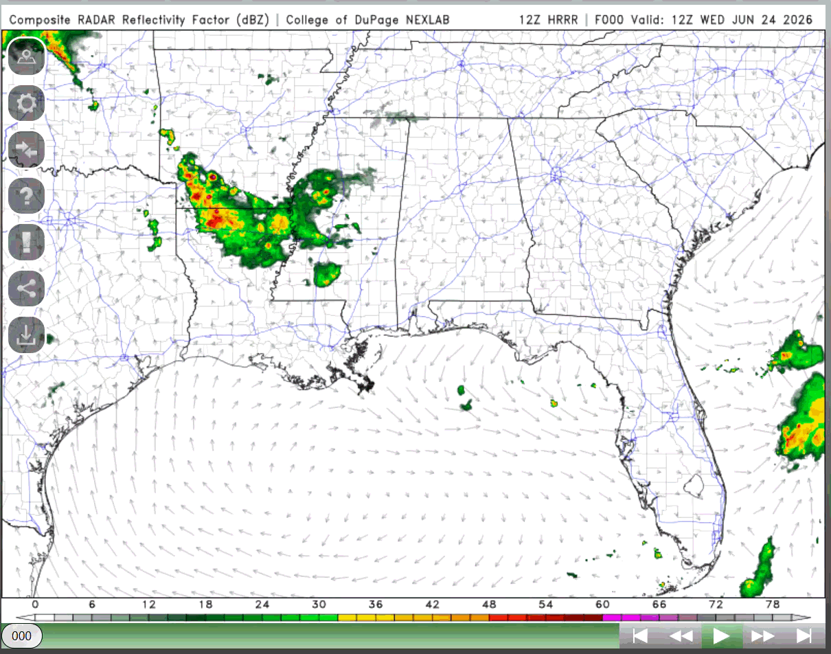
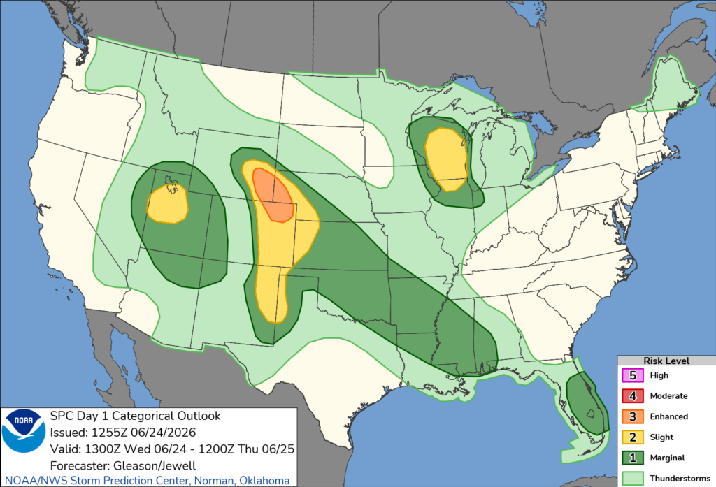
The next couple of days will see some rounds of showers and thunderstorms as upper-level shortwaves impact the area, today leaving most of Mississippi and parts of southern Alabama under a marginal risk (from the SPC) for severe weather. Most of the region has the chance to see thunderstorms today. Some of these storms can be strong as plenty of instability and low-level shear can support deeper development.
Tomorrow, there is a chance to see more thunderstorms, shifted more to MS, AL, and GA. Some of these storms could be strong, so make sure to keep checking in with the weather.
Storm potential continues through Friday, greatest chance shifting to the east in Georgia. Chances for rain decrease into the weekend as the upper-level ridging and heat returns. By next week, summer weather returns, high temperatures increasing all the way up to the upper 90s just in time for Fourth of July weekend!
3-DAY TRAVEL FORECAST
AIRPORTS
KIAH/KHOU (Houston) – No weather-related delays are expected for the next three days.
KSHV (Shreveport) – No weather-related delays are expected for tomorrow and Friday. This afternoon, a slight chance for showers and thunderstorms before 4pm could cause brief delays due to lightning.
KBTR (Baton Rouge) – No weather-related delays are expected for the next three days.
KJAN (Jackson) – A flood warning is in effect today through tomorrow afternoon. Flight delays are anticipated due to lightning and heavy rainfall, with the greatest impacts today. No delays are expected on Friday.
KMSY (New Orleans) – No weather-related delays are expected for the next three days. Tomorrow, a slight chance of showers and thunderstorms exists, but weather delays are not expected.
KMOB (Mobile) – Weather-related delays are possible today through tomorrow due to scattered showers and thunderstorms, greatest impacts in the afternoon and evenings. Friday, a slight chance for thunderstorms exists, but no significant delays are expected.
KATL (Atlanta) – No weather-related delays are expected today and tomorrow. Afternoon showers and thunderstorms Friday afternoon through night could cause brief delays due to lightning.
KTLH (Tallahassee) – No weather-related delays are expected today. Tomorrow afternoon through Friday evening could see intermittent delays due to lightning.
KBHM (Birmingham) – No weather-related delays are anticipated for the next three days. Isolated showers and thunderstorms are possible tomorrow through tomorrow, but impacts to aviation should be minimal.
HIGHWAYS
I-10 – Tonight, and tomorrow night in southern Mississippi and Alabama will be impacted by showers and thunderstorms, some could be strong, so generally not a good time to travel in those areas. Friday is looking clearer, but isolated showers and thunderstorms are possible along 1-10.
I-20 – Today, heavy showers and thunderstorms are occurring along 1-20 in Louisiana and Mississippi, so try not to travel in these areas. Tomorrow, scattered showers and thunderstorms are possible especially in the afternoon. Friday is a better travel day, but isolated showers and thunderstorms cannot be ruled out.
I-49 – Today, heavy showers and thunderstorms are occurring in northern Louisiana and will continue to move to southern portions of the state until they dissipate later tonight. Tomorrow and Friday are better travel days, although an isolated shower or thunderstorm cannot be ruled out.
I-55 – Today, heavy showers and thunderstorms are expected for Mississippi. Tomorrow, scattered showers and thunderstorms will occur along the highway in Mississippi throughout the day, so not the best travel days for the next 2 days. Friday is looking to be a lot clearer, so a better time to travel.
I-59 – Today is generally clear for I-59 in Alabama, but Mississippi will be seeing heavy showers and thunderstorms so try to avoid traveling along the highway in MS. Tomorrow and Friday, scattered showers and thunderstorms will occur, so make sure to pay attention to that and be careful when driving.
I-65 – Today, southern Alabama will see heavy showers and thunderstorms so be careful when driving along this highway in that area. Tomorrow afternoon/evening, same trend in the weather, so be cautious of any storms that pop up. Going into Friday, scattered showers and thunderstorms will occur in Alabama.
I-75 – Today is a good travel day, looking at tomorrow and Friday, scattered showers and thunderstorms will start developing in Georgia, some may be strong so be careful and keep up to date with the weather if you are traveling on those days.
CITY FORECASTS
Houston, TX
Today/tonight – Today will be hot and sunny, the high near 95 and heat index values near 105. Make sure to take care of yourself when outside. Tonight, mostly clear skies and a low of 75.
Tomorrow – Again, another hot day with sunny skies and a high of 93. Heat index values could reach as high as 102, so again take care of yourself when outside. The low falls to 77 and partly cloudy skies for tomorrow night.
Friday – Once again, another hot day with sunny skies. The high will be in the mid 90s and wind gusts up to 20 mph. Friday night will have mostly clear skies and a low in the upper 70s.
Shreveport, LA
Today/tonight – Until 1:00pm today, a flood watch is in effect. A 20% chance of showers and thunderstorms in the early afternoon. The high will be near 92 with mostly sunny skies. Tonight, will be mostly clear with a low of 75.
Tomorrow – Sunny skies for tomorrow and a high near 94, so it is looking to be hot. The low will fall to 75 with mostly clear skies for tomorrow night. Make sure to stay hydrated when outside!
Friday – Mostly sunny skies are expected for Friday, and a high in the lower 90s. Mostly clear skies for Friday night and a low in the upper 70s.
Baton Rouge, LA
Today/tonight – Mostly sunny skies with a high near 93 for today. Tonight, the low will fall to 75 and partly cloudy skies are expected.
Tomorrow – Another hot day, mostly sunny skies and a high near 94. Tomorrow night, mostly clear skies and a low near 75.
Friday – Once again, another hot day! Sunny skies with a high in the mid 90s. Friday night, mostly clear skies are expected with a low in the mid 70s.
Jackson, MS
Today/tonight – A flood warning is in effect today until 4:36pm tomorrow. A steady high temperature of 80, today a 90% chance of showers and thunderstorms throughout the rest of the day. Some strong storms are possible, producing heavy rain. Up to a quarter inch of rain is expected, more in thunderstorms. Chance for thunderstorms continues overnight, the low falling to 70.
Tomorrow – The flood warning is in effect until 4:36pm tomorrow. Chance of showers and thunderstorms is 30%, mainly in the afternoon. Other than that, mostly sunny skies with a high near 90, heat index values as high as 101. The low will fall around 73, skies clearing Thursday night.
Friday – Sunny skies with a high in the low 90s. The low will fall in the mid 70s and Friday night, skies will be mostly clear.
New Orleans, LA
Today/tonight – Mostly sunny skies and a high near 92 for today. Tonight, the low will fall near 77 and partly cloudy skies.
Tomorrow – There is a 20% chance of showers and thunderstorms tomorrow afternoon. Other than that, mostly sunny skies with a high near 93. The low will fall around 77.
Friday – Sunny skies for Friday and a high in the lower 90s. Friday night, clear skies are expected with a low in the upper 70s.
Mobile, AL
Today/tonight – Chance of showers and thunderstorms is 60% mainly in the afternoon. The high will be 92. Thunderstorms can produce higher amounts of rain, but up to a quarter inch of rain is anticipated. The low will fall around 72, chance for showers and thunderstorms continuing overnight.
Tomorrow – Showers and thunderstorms are possible throughout the day, chance of precipitation at 60%. The high will be near 89. Chance of precipitation continues tomorrow night, but not overnight. The low will fall near 74.
Friday – A slight chance of showers and thunderstorms possible in the afternoon. Other than that, sunny skies with a high in the lower 90s. The low will fall in the mid 70s.
Atlanta, GA
Today/tonight – Mostly sunny skies with a high near 87. Tonight, mostly clear skies with a low near 69. Not much of anything going on today!
Tomorrow – Mostly sunny skies and a high near 89. The low will fall around 72 with partly cloudy skies.
Friday – A 40% chance of showers and thunderstorms for the afternoon. Other than that, skies will be mostly sunny and a high near 90. Chance for showers and thunderstorms continues Friday night.
Tallahassee, FL
Today/tonight – Sunny skies and a high near 93 for today. Tonight, partly cloudy skies and a low of 72.
Tomorrow – A 30% chance of showers and thunderstorms for tomorrow afternoon/night. A high near 93 and a low around 73.
Friday – A 50% chance of showers and thunderstorms for Friday afternoon, continuing into the late evening. The high will fall in the low 90s and a low in the mid 70s.
Birmingham, AL
Today/tonight – There is a 20% chance of showers and thunderstorms in the afternoon. Other than that, mostly sunny skies with a high near 86. A slight chance for showers and thunderstorms tonight before 7pm. The low will fall around 69.
Tomorrow – a 20% chance of showers and thunderstorms for tomorrow afternoon. Other than that, mostly sunny skies and a high near 89. The low will fall near 72.
Friday – Mostly sunny skies and a high in the lower 90s. Mostly clear skies for Friday night, and a low in the mid 70s. Not much going on for Friday.


