It’s going to be hot, hot, hot!
Rain won’t be much of a problem, except for spotty afternoon showers and thunderstorms, mainly along the coast. The most impactful weather will be the heat.
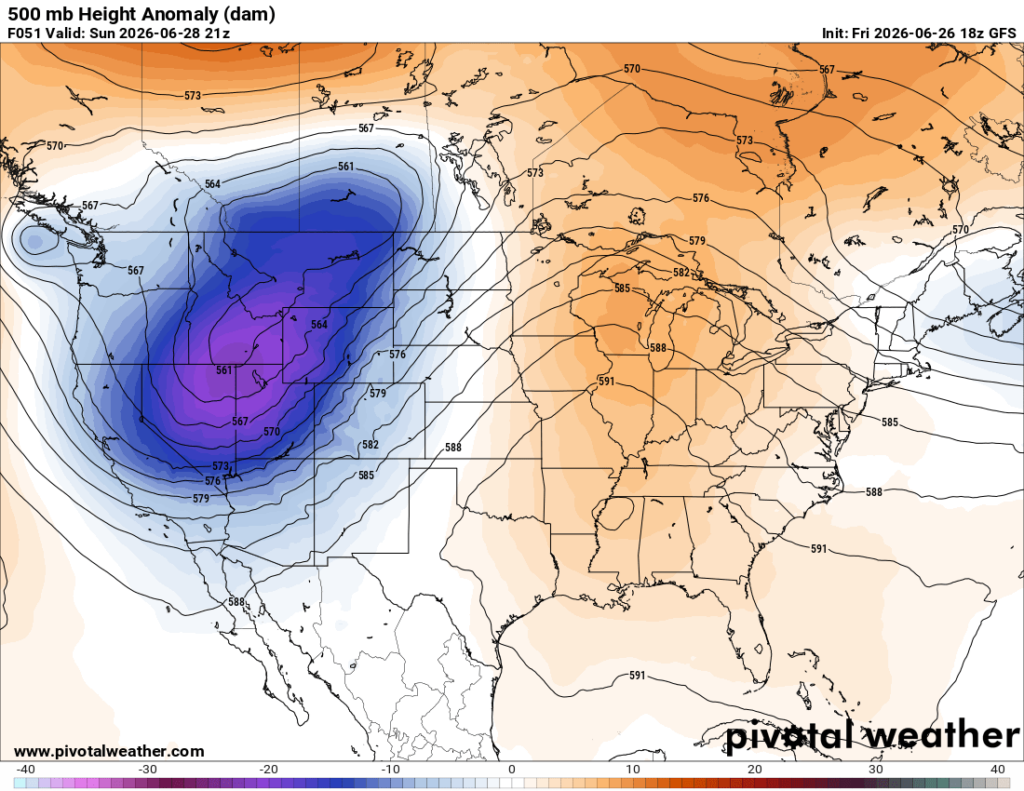
Long-range models show ridging strengthening this weekend and peaking early next week. The sinking air and high pressure that comes with ridging will limit storm development. This will also bring the hottest temperatures so far this summer. For those traveling, impacts will be minimal unless your car’s AC goes out… Please drink plenty of water and limit time outdoors to avoid heat exhaustion.
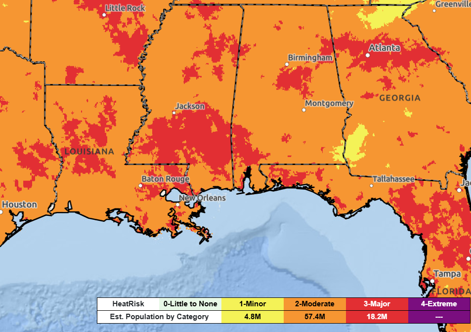
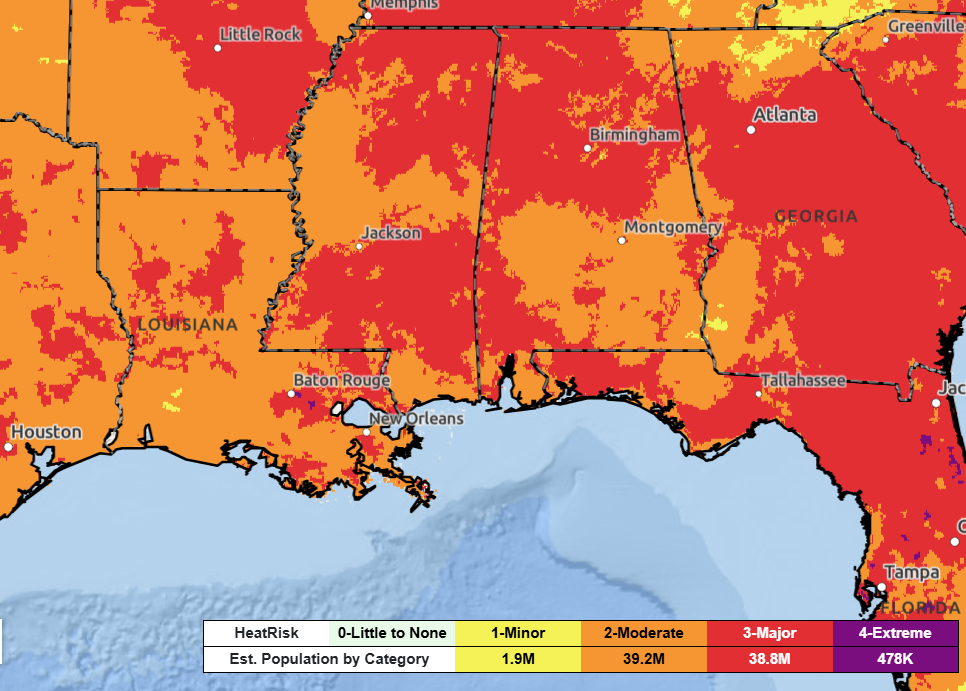
The humidity this weekend through mid-next week will result in heat index values of 105 to 110 degrees across much of the area. On Saturday, pockets of major heat risk (highlighted in red) will expand and become more widespread by Sunday.
Major heat risk means the heat can affect anyone without proper cooling and hydration, and may also strain health systems and industries.
Courtesy: wpc.ncep.noaa.gov
The next best chance for rain will be sometime midweek, when a trough in the 500 mb level and a surface low move through the region, triggering storms and bringing temperatures down a bit.
3-DAY TRAVEL FORECAST
AIRPORTS
KIAH / KHOU (Houston) – A stray afternoon storm is possible on Saturday. Saharan dust may cause hazy skies late Sunday. Aside from that, no weather-related issues anticipated through the weekend.
KSHV (Shreveport) – Hot! Aside from that, no weather-related issues anticipated through the weekend.
KBTR (Baton Rouge) – Hot and a stray afternoon storm is possible. Aside from that, no weather-related issues anticipated through the weekend.
KMSY (New Orleans) – Hot and a stray afternoon storm is possible. Aside from that, no weather-related issues anticipated through the weekend.
KJAN (Jackson) – Hot! Aside from that, no weather-related issues anticipated through the weekend.
KMOB (Mobile) – Hot and a stray afternoon storm on Saturday is possible. Aside from that, no weather-related issues anticipated through the weekend.
KBMH (Birmingham) – Hot! Aside from that, no weather-related issues anticipated through the weekend.
KTLH (Tallahassee) – Hot and evening showers and thunderstorms possible Saturday. Some intermittent flight delays are possible for lightning, mainly after 4PM. Aside from that, no weather-related issues anticipated through the weekend.
KATL (Atlanta) – Low-end chance for afternoon showers and storms possible each day. Some intermittent flight delays are possible for lightning. But most flights between 10a and 2p should be not be impacted by weather.
HIGHWAYS
I-10
Mostly dry and good traveling through the weekend. Saturday afternoon, scattered storms are expected mainly after 4 PM along the Florida Panhandle. Drive with caution if caught, with frequent lightning and heavy rain.
I-20
Travel forecast looks good for the weekend, unless you are traveling in northern Georgia near Atlanta. In that case, watch out for afternoon showers and thunderstorms each day this weekend. Visibility can be limited at times due to heavy downpours.
I-49
Looking good through the next three days. No widespread major concerns anticipated. A spotty afternoon shower or storm can’t be ruled out, especially the further you drive south.
I-55 & I-59
Looking good through the next three days. No widespread major concerns anticipated. A spotty afternoon shower or storm can’t be ruled out, especially near New Orleans.
I-65
Again, looking hot and dry through the next three days. No widespread major concerns anticipated. A spotty afternoon shower or storm can’t be ruled out, mainly near the coast and far eastern portions of Alabama.
I-75
Scattered thunderstorms are expected near and north of Atlanta Saturday and Sunday afternoons. Stronger storms are capable of strong wind gusts, frequent lightning, and heavy rainfall. Watch for ponding on roads, and visibility may be reduced at times.
Evening showers and thunderstorms are also possible in northern Florida, mainly after 4 PM each day.
CITY FORECASTS
Houston, TX
Tonight – Warm and muggy night under partly cloudy skies. Low of 78. Breezy with a southerly wind of 10 mph, gusts up to 20mph.
Saturday – Mostly sunny. Hot weather will continue, with a high of 94, but it will feel closer to 102. Stay hydrated and reduce time outdoors during peak heat! Breezy with a southerly wind of 10 mph, gusts up to 20mph. Stray afternoon storm possible. Rain chance: 10%
Sunday – Mostly sunny and hot with a high near 95, may feel closer to 103. A plume of Saharan dust is expected to blow through late Sunday bringing reduced air quality and hazy skies.
Shreveport, LA
Tonight – Warm and muggy with mostly cloudy skies. Low around 77. May catch a stray shower. Rain chance: 10%
Saturday – Breezy and hot. Clouds will give way to sunshine by the afternoon. High near 94, but it may feel closer to 102. South winds around 10mph, with gusts up to 20 mph.
Sunday – Very similar to Saturday. Clouds will give way to sunshine by the afternoon. High near 94, but it may feel closer to 102. South winds 5-10mph.
Baton Rouge, LA
Tonight – Warm and muggy with a low of 75 under clear skies. Southwest wind 5 to 10 mph.
Saturday –Mostly sunny and hot. High near 94, but it may feel closer to 105. Calm southwest wind. A stray storm is possible in the morning and afternoon. Rain chance: 10%.
Sunday – Sunny with extreme heat possible. High near 95, but it will feel closer to 105. Calm southwest wind. A stray storm is possible in the afternoon. Rain chance: 10%.
New Orleans, LA
Tonight – Warm and muggy with a low of 79 under clear skies. South wind 5 to 10 mph.
Saturday –Heat Advisory in effect. Sunny and hot with a high near 93, but it may feel like 106. South wind 5 to 10 mph. A stray storm is possible during the afternoon and evening. Rain chance: 10%.
Sunday – Sunny with extreme heat possible. High near 93, but it will feel closer to 105. Calm southeast wind. A stray storm is possible during the afternoon and evening. Rain chance: 10%.
Jackson, MS
Tonight – Partly cloudy with a low around 75. Calm south wind. You may catch a stray shower. Rain chance: 10%.
Saturday –Morning clouds will give way to sunshine by the afternoon. High near 93, but it may feel closer to 105. Southwest wind 5 to 10 mph.
Sunday – Very hot with a high near 94, but it may feel closer to 106. Morning clouds will give way to sunshine by the afternoon. Calm southwest wind. Drink water!
Birmingham, AL
Tonight – Partly clear with a low around 75. Calm southwest wind.
Saturday –Partly sunny with a chance for a stray afternoon shower. High near 92, but it may feel closer to 100. Southeast wind 5 to 10 mph. Rain chance: 10%
Sunday – Very hot with a high near 94, but it may feel closer to 103. Morning clouds will give way to sunshine by the afternoon. Calm westerly wind.
Mobile, AL
Tonight – Mostly clear with a low of 78. South wind 5 to 10 mph.
Saturday –Mostly sunny and hot. High near 93, but it may feel like 105. Southeast winds 5 to 10 mph. A stray storm is possible during the afternoon and evening. Rain chance: 10%.
Sunday – Very hot and partly sunny. Morning clouds will give way to sunshine during the afternoon. High near 95, but it may feel like 107. Calm south wind. Drink water!
Tallahassee, FL
Tonight – Partly cloudy with a low of 73. A stray storm is possible. Calm southwest wind. Rain chance: 10%
Saturday –Sunny with isolated showers and thunderstorms possible during the evening, mainly after 4 PM. High near 93, but it may feel like 102. Calm westerly wind. Rain chance: 30%
Sunday – Very hot and sunny. High near 95, but it may feel like 105. Calm northwest wind. Drink water!
Atlanta, GA
Tonight – Clear skies with a low near 74. Calm southwest wind.
Saturday –Mostly sunny with afternoon storms possible, mainly after 2 PM. Stronger storms may bring frequent lightning and strong wind gusts. High near 91, but it may feel like 97. West winds 5 to 10 mph, with gusts up to 20 mph. Rain chance: 20%
Sunday – Mostly sunny with a stray afternoon storm possible, mainly after 2 PM. High near 91, but it may feel like 98. West winds 5 to 10 mph, with gusts up to 20 mph. Rain chance: 20%


