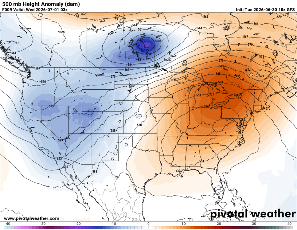
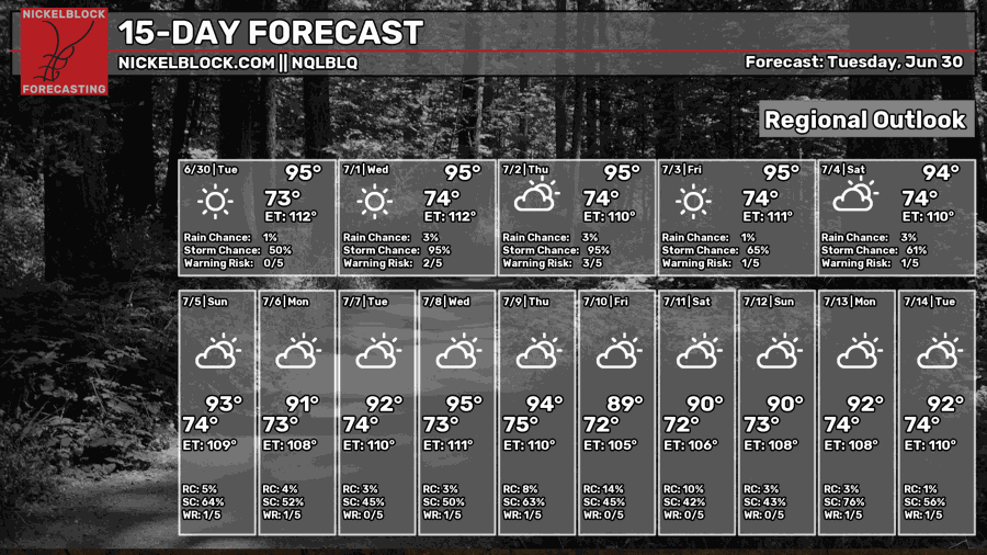
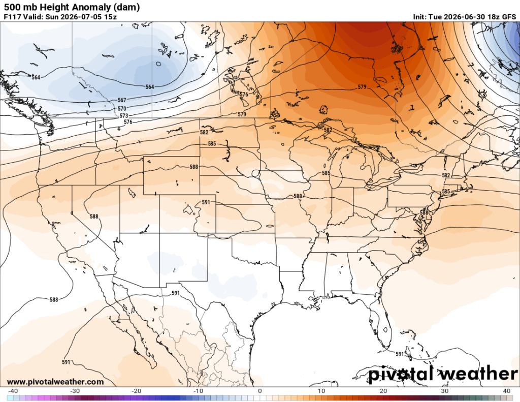
The hot temperatures and humidity are sticking around, unfortunately, through the end of this week thanks to ridging that remains in place across much of the southeast. As a result, a heat advisory is in effect today and has been extended through Wednesday, though additional heat advisories may be issued throughout the week.
Tomorrow will bring the highest coverage of scattered storms before we return to the more typical afternoon sea breeze storms along the coast through the weekend. While storms may temporarily help cool things down, most won’t develop until later in the afternoon, allowing heat indices to climb quite high first. So don’t count on the storms to provide much relief!

TONIGHT
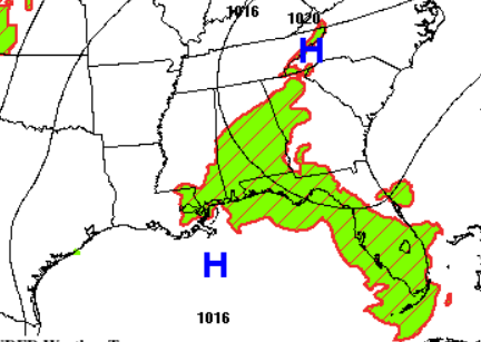
This evening and into the early overnight hours, isolated thunderstorms will be possible across southern Mississippi and eastern portions of southeast Louisiana. The Storm Prediction Center has placed the area under a Marginal Risk (level 1/5) for severe weather. Main concerns include heavy rain, frequent lightning, wind gusts up to 60 mph, and small hail. The tornado threat remains very low, but as always, it is not zero.
These storms are expected to weaken and dissipate overnight, leaving partly cloudy and muggy conditions in place, with lows hovering around 77 degrees.
TOMORROW
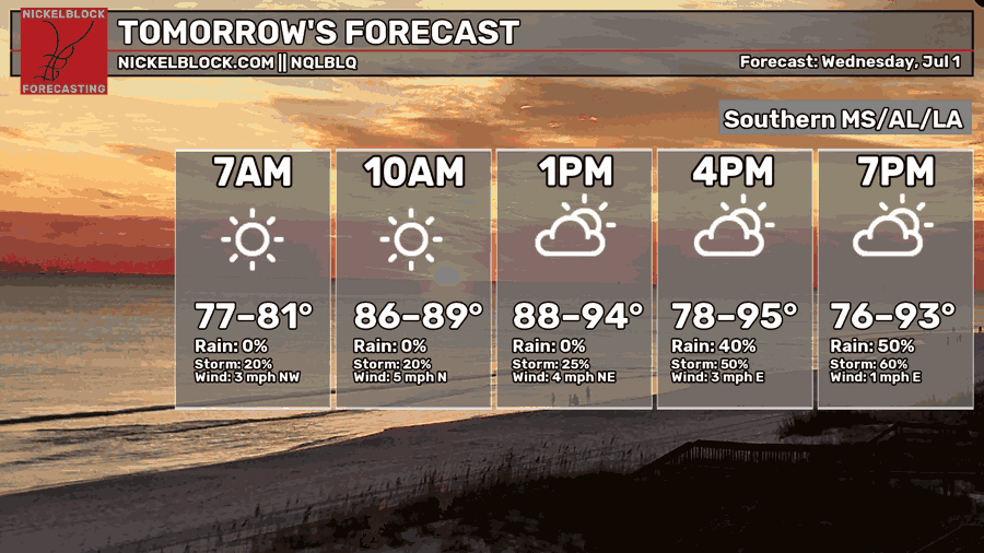
Wednesday, the first day of July, looks to feature higher coverage of scattered showers and thunderstorms. We’ll start the morning with storms along the Louisiana coast near Houma, with coverage gradually increasing northwestward into scattered storms across much of southeastern Louisiana and near Baton Rouge.
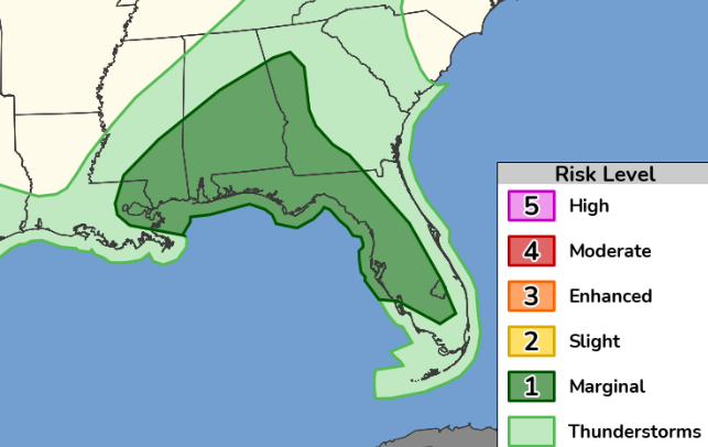
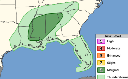
A very moist and unstable atmosphere will be in place (dew points around 77 degrees) which could support stronger storms capable of damaging winds, frequent lightning, and heavy rainfall. A brief, weak tornado can’t be completely ruled out. As a result, the Storm Prediction Center has placed much of Mississippi under a Marginal Risk for severe storms tomorrow.
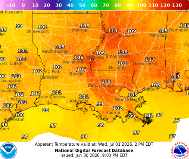
The very moist atmosphere we just mentioned will make things feel quite sticky, with apparent temperatures approaching 110 degrees. An extreme heat warning is in effect tomorrow, so limit time outdoors if possible and make sure to drink water!

THE DAY AFTER TOMORROW
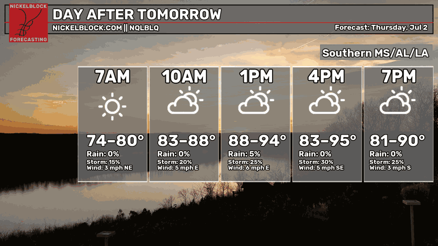
Thursday will be another sunny and hot day. Afternoon showers and thunderstorms will mainly develop along sea breeze boundaries near the coast and across southern Louisiana, including areas such as Houma. Humidity will remain high, making it feel closer to 105 degrees at times. Drink plenty of water!

EXTENDED OUTLOOK
Looking ahead, we can expect typical summer conditions with hot temperatures and scattered afternoon storms. However, by Sunday the ridge will begin to break down a bit, allowing storm coverage to increase late this weekend and into early next week.
However, the heat and humidity will stick around, with highs in the 90s and dew points in the 70s!
DAY-BY-DAY FORECAST
Tonight – Lingering storms tonight mainly before 2 AM and along the coast. Some could be severe with strong wind gusts and frequent lightning. Otherwise, partly cloudy and muggy with lows near 77. Light wind blowing from the east. Rain chance: 30%
Wednesday – Extreme heat warning in effect. Humid and hot! Highs will reach 95, but will feel like 110, especially for those near Baton Rouge. Isolated showers and thunderstorms, mainly in the afternoon and evening hours. Some storms may become severe with damaging wind gusts and frequent lightning. Otherwise, mostly sunny skies. Drink water! Rain chance: 80%
Wednesday Night – Storms may linger until midnight before skies settle into a mostly clear night. Low around 74 with a light breeze from the east. Rain chance: 30%
Thursday – Another sunny and hot day. Low-end chance of afternoon showers and thunderstorms. Highs near 95, may feel closer to 106. Light winds blowing from the east. Drink water! Rain chance: 30%
Thursday Night – Mostly clear, with a low around 74. Southeast calm wind.
Friday – Heat and humidity continue building with highs near 95, but it will feel closer to 105. Sunny skies and light winds blowing from the east. Low-end chance of a stray shower or thunderstorm, mainly after 1pm. Rain chance: 20%
Friday Night – Mostly clear skies with a low of 74. Calm easterly winds.
Fourth of July– Sunny and hot. Isolated showers and thunderstorms, mainly in the afternoon. Highs near 94, may feel closer to 100. Calm southwest wind. Rain chance: 40%
Saturday Night – Partly cloudy skies with a low around 74. Low-end chance of a lingering storm. Calm wind blowing from the southwest. Rain chance: 20%
Sunday– Showers and thunderstorms likely, mainly after 1pm. Otherwise, mostly sunny, with highs near 93. Calm southwest wind. Rain chance: 60%.
Sunday Night – Partly cloudy with a low around 74. Calm south wind. Chance for rain or storms around 20%
Monday – Showers and thunderstorms likely, mainly in the afternoon. Highs near 92. Otherwise, mostly sunny with a calm south wind. Rain chance: 60%
Monday Night – Partly cloudy with a low around 73. Southwest wind 5mph. Chance for rain or storms around 20%


