Well the title might be a little bit of an exaggeration but we’re definitely gonna get a lot of rain.
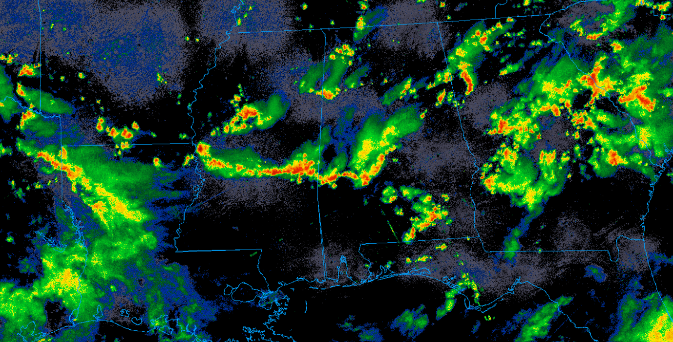
So yeah, there’s storms everywhere. This is being driven by a weak frontal boundary sagging slowly south. Surface convergence and seasonable strong instability has allowed for numerous showers and storms to develop across the region.
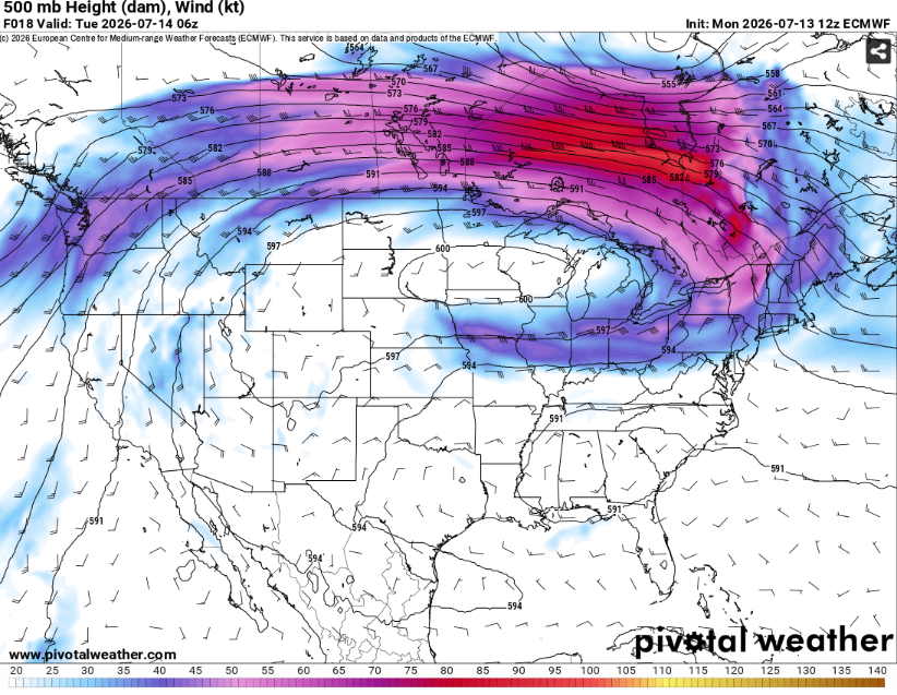
In the mid levels, the main jet streak is far to the north in Canada. While the South is only experiencing weak flow, an area of cyclonic curvature is meandering overhead. This will allow for enhanced rising motion helping convection maintain itself. The storms will be capable of heavy rain, frequent lightning, and maybe some isolated, strong downbursts.
Tomorrow will be more of the same but with the main initiating boundary further south (and so thus the most likely area for widespread convection).
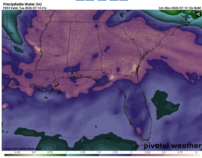
Vertical profiles will be very saturated. Given the slow moving nature of the thunderstorms, flash flooding will be a concern. Never drive into water! This is how most flash flooding deaths occur.
Temperatures will be cooler in the areas that receive clouds and precipitation. Highs will likely be in the low to mid 80s.
Expect drier conditions by mid week as the frontal boundary washes out.
Airport Forecasts
Houston (KIAH/KHOU)- Off and on storms for the next couple days. It won’t rain the entire time but there will likely be some delays for lightning or downbursts.
Shreveport (KSHV)- Thunderstorms clear by mid evening. There may some scattered convection in the area tomorrow after which could cause some quick delays for lightning or downdrafts.
Baton Rouge (KBTR)- Tricky one. There will likely be several rounds of storms in the area in the next 48 hours. Expect occasional delays for lightning or microbursts but none should be particularly long.
New Orleans (KMSY)- Not too bad. There may be some storms tomorrow afternoon. This may lead to some brief delays for lightning or downbursts.
Jackson (KJAN)- Stormy. There will likely be multiple waves over the next two days causing some delays for lightning or downdrafts. The driest time appears to be during the morning tomorrow.
Mobile (KMOB)- Scattered storms tonight and then tomorrow afternoon. This could cause some delays for lightning or downbursts. Wednesday looks calmer.
Birmingham (KBMH)- Numerous thunderstorms likely through Wednesday afternoon. This will likely lead to some delays for lightning or microbursts. It won’t rain the whole time but significant dry time may be limited.
Tallahassee (KTLH)- Multiple chances for storms over the next few days. Right now Wednesday morning looks the driest. There may be some delays for lightning or downdrafts.
Atlanta (KATL)- Lots of storms these next couple days. It won’t rain for the entire time but there will be multiple rounds. There will likely be some delays for lightning or downbursts.
Highways
I-10 – There will likely be a large group of thunderstorms from the western Florida Panhandle through Houston area tomorrow morning. Redevelopment is possible in the late afternoon in the same areas. Make sure to watch out for ponding on the roadways.
I-20 – Some isolated thunderstorms are possible across Mississippi tonight. There will likely be at least scattered storms from eastern Louisiana to Atlanta tomorrow afternoon. Use caution when encountering heavy rain.
I-49 – Not horrible. Some scattered storms are likely across western Louisiana tomorrow but it won’t be a washout.
I-55 and I-59 – More storms. Afternoon convection is most likely across Mississippi tomorrow. Be careful of water on pavement.
I-65 – Scattered convection develops across Alabama in the early afternoon. It won’t rain everywhere but some places on the interstate will likely see heavy rain so be aware.
I-75 – Convection in the area may linger into the am hours. There may some redevelopment across central Georgia tomorrow after that may cause some slowdowns.
City Forecasts
Houston, TX
Tonight- Mostly cloudy with a low in the mid 70s. Scattered thunderstorms likely.
Tomorrow- Mostly cloudy with a high in the low 80s. Numerous showers and thunderstorms likely.
Wednesday- Scattered storms likely. Mostly cloudy with a high in the mid 80s.
Shreveport, LA
Tonight- Storms clear early. Mostly cloudy with a low in the low 70s.
Tomorrow- Scattered afternoon thunderstorms possible. Increasing clouds with a high in the upper 80s.
Wednesday- Partly sunny with a high in the upper 80s. Scattered thunderstorms possible.
Baton Rouge, LA
Tonight- Scattered thunderstorms possible. Mostly cloudy with a low in the mid 70s.
Tomorrow- Scattered thunderstorms likely. Mostly cloudy with a high in the mid 80s.
Wednesday- Partly sunny with a high in the low 90s. Isolated afternoon thunderstorms possible.
New Orleans, LA
Tonight- Mostly cloudy with a low in the mid 70s. No rain.
Tomorrow- Mostly cloudy with a high in the mid 80s. Scattered afternoon afternoon thunderstorms possible.
Wednesday- Partly sunny with a high in the low 90s. Scattered afternoon thunderstorms possible.
Jackson, MS
Tonight- Scattered thunderstorms likely. Mostly cloudy with a low in the low 70s.
Tomorrow- Scattered afternoon thunderstorms likely. Mostly cloudy with a high in the upper 80s.
Wednesday- Partly sunny with a high in the upper 80s. Scattered afternoon thunderstorms possible.
Birmingham, AL
Tonight- Mostly cloudy with a low in the low 70s. Scattered showers and thunderstorms likely.
Tomorrow- Numerous showers and thunderstorms. Mostly cloudy with a high in the low 80s.
Wednesday- Scattered afternoon thunderstorms likely. Mostly cloudy with a high in the mid 80s.
Mobile, AL
Tonight- Scattered thunderstorms likely. Mostly cloudy with a low in the mid 70s.
Tomorrow- Scattered afternoon thunderstorms likely. Party sunny with a high in the mid 80s.
Wednesday- Mostly sunny with a high in the low 90s. Dry.
Tallahassee, FL
Tonight- Chance for scattered showers and storms. Mostly cloudy with a low in the low 70s.
Tomorrow- Scattered afternoon thunderstorms likely. Mostly cloudy with a high in the upper 80s.
Wednesday- Increasing clouds with a high in the low 90s. Scattered afternoon thunderstorms possible.
Atlanta, GA
Tonight- Widespread showers and thunderstorms. Cloudy with a low around 70.
Tomorrow- Cloudy with a high in the low 80s. Numerous showers and thunderstorms.
Wednesday- Increasing clouds with a high in the mid 80s. Scattered afternoon thunderstorms likely.


