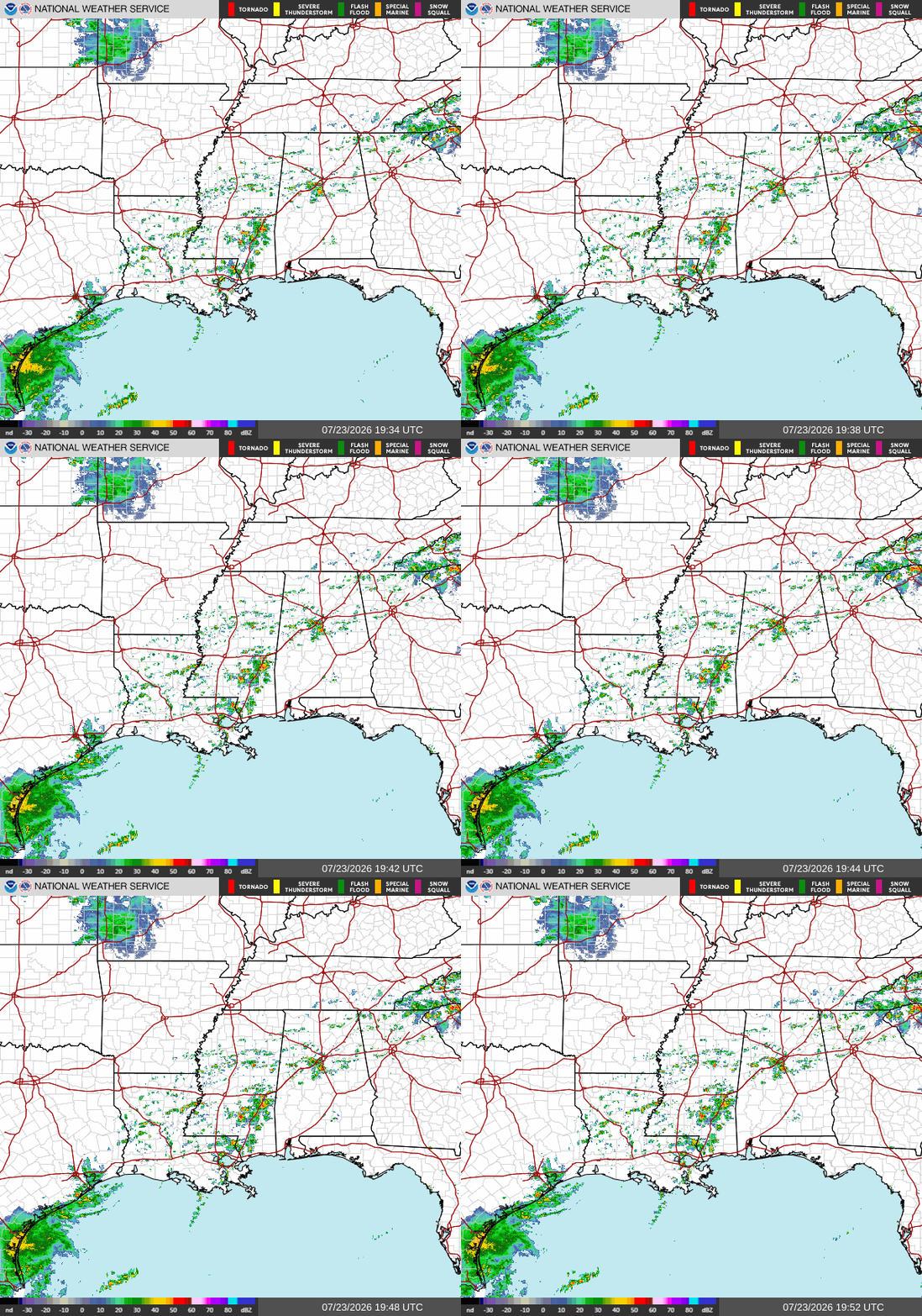
Good afternoon! As I’m writing this at 3p CDT, we have a bit of action on our radar. First, you can see tropical storm Bertha, whose center is at the TX/LA border, and if you look further south in Texas, you can see her main area of convection.
There’s also an area of storminess in south central Mississippi between Hattiesburg and Meridian. These storms are being caused by the outer bands of tropical storm Bertha which are coming onshore. These storms will rumble on until around 10 tonight when most of them should be gone. Rainfall around a quarter of an inch is possible tonight, but some places hit directly by a storm could see more. Be aware of heavy rains, gusty winds and lightning.
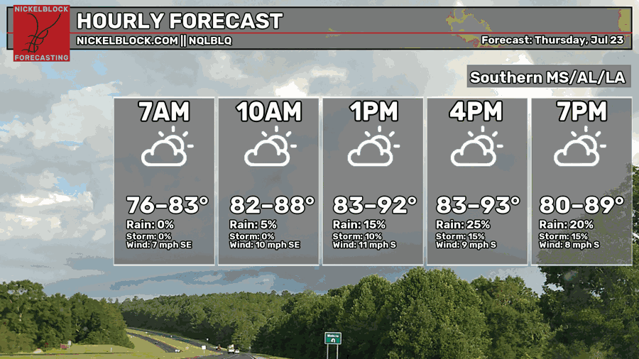
While high temperatures this afternoon are still going to be quite hot, in the low-mid 90s for most, it’s a slight improvement from yesterdays upper 90s. As usual, make sure to stay hydrated, wear sun protection, and wear cool clothes if you will be outdoors for a long period of time.
Tomorrow
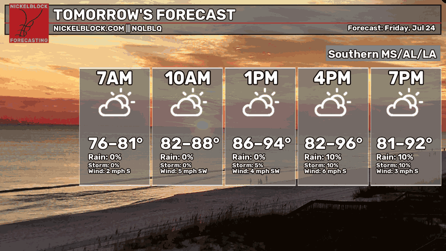
Temperatures will go back to being a few degrees above average tomorrow, with afternoon highs in the mid 90s for most. Morning lows will only bottom out in the mid-upper 70s.
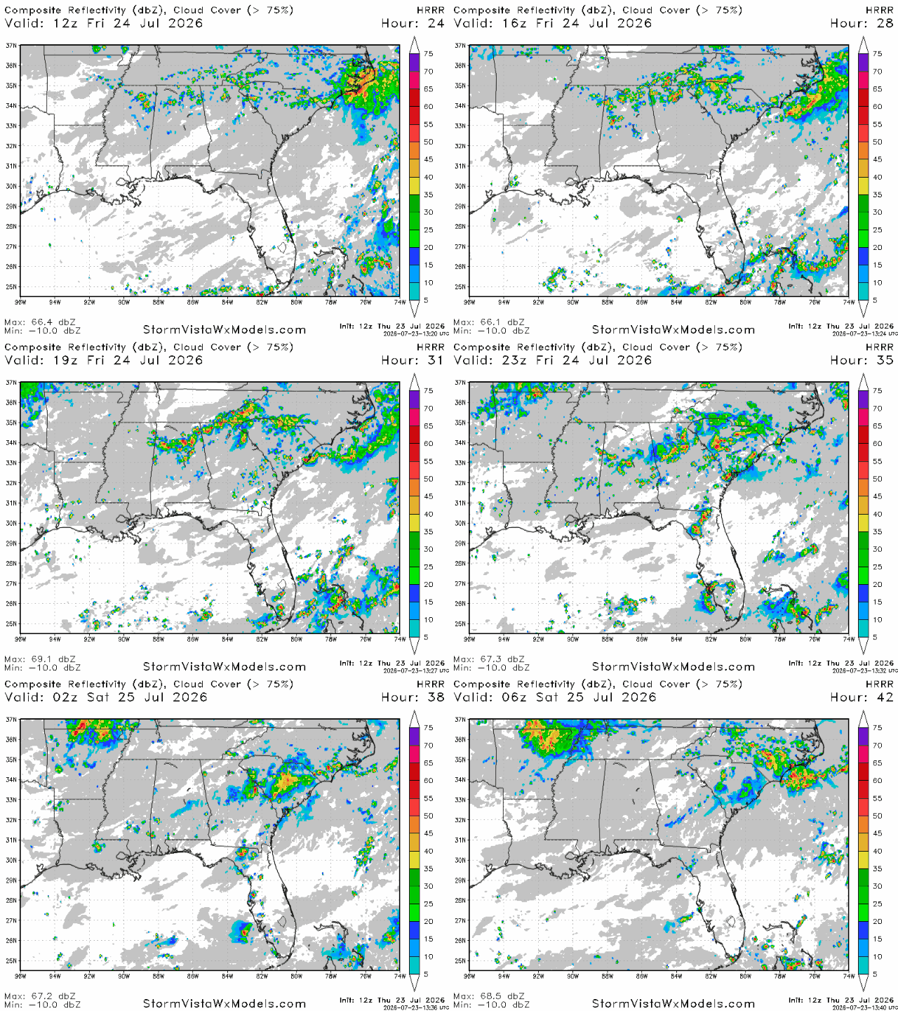
Storms closer to the coast will be pretty sparse tomorrow. Further north, it’s a bit of a different story. Storms look likely to fire up around midday in northern Alabama and northeastern Mississippi. These storms will move towards the southeast, and will be mostly fizzled out by 8 tomorrow night.
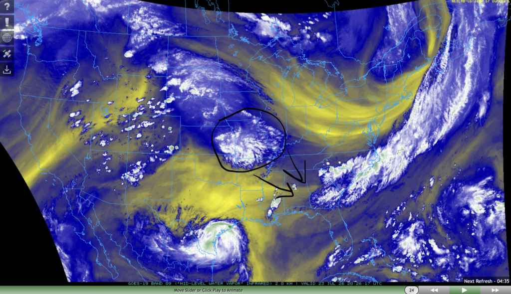
These storms can be explained by looking at the current conditions today. While we are situated under a ridge of high pressure right now, there is currently an area of mid level moisture over Missouri and Kansas. By tomorrow, this area of water vapor will continue to move southwards, eventually reaching the TN/MS/AL border.
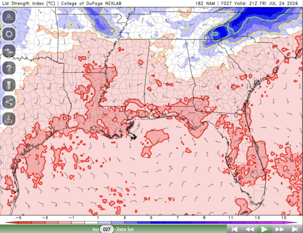
I also believe that these storms may become a bit more robust and organized. This is due to the lid strength index, which looks to be pretty close to neutral for tomorrow in the areas previously mentioned. The lid strength index is a measure of how much the mid level atmosphere is suppressing storm development. If it’s too low, storms will pop up and burn through their energy too quickly, resulting in disorganized storms. If it’s too high, no storms will form.
Tomorrow, it looks like we’ll have the best of both worlds with a lid strength index that’s not too high and not too low, resulting in storms that build up energy during the day, then “pop” in the evening.
Airport Forecast
KHOU/KIAH (Houston) – Current: temperature is 87ºF, dew point is 76ºF, sky conditions are overcast, winds are coming out of the north at 10 mph, and visibility is 10 miles. Tonight: Breezy and potentially stormy conditions due to tropical storm Bertha are in store for tonight until around midnight. Some delays and cancellations are possible.
KATL (Atlanta) – Current: temperature is 86ºF, dew point is 72ºF, sky conditions are mostly cloudy, winds are coming out of the west at 10 mph with gusts up to 17 mph, and visibility is 10 miles. Tonight: winds will continue to be a bit gusty tonight, and storms are possible late tonight until the early morning tomorrow. Very minor delays are possible.
KMSY (New Orleans) – Current: temperature is 83ºF, dew point is 78ºF, sky conditions are mostly cloudy, winds are coming out of the south at 10 mph, and visibility is 7 miles. Tonight: there is a slight chance of storms this afternoon, but skies should be clear by the evening. No delays are expected.
KBTR (Baton Rouge) Current: temperature is 89ºF, dew point is 76ºF, sky conditions are partly cloudy, winds are coming out of the south at 12 mph with gusts up to 23 mph, and visibility is 10 miles. Tonight: gusty conditions will continue this afternoon, and showers and thunderstorms are possible until around 7 tonight. Winds will calm down by tonight. Minor delays are possible.
KSHV (Shreveport) – Current: temperature is 88ºF, dew point is 75ºF, sky conditions are overcast, winds are coming out of the northeast at 14 mph, and visibility is 10 miles. Tonight: gusty conditions will continue until this evening, and the slight chance for showers and storms will persist from this afternoon into the evening. Minor delays are possible.
KJAN (Jackson) – Current: temperature is 87ºF, dew point is 77ºF, sky conditions are overcast, winds are coming out of the southeast at 6 mph, and visibility is 10 miles. Tonight: storms are possible beginning in the late afternoon and lasting until the evening. Very minor delays are possible.
KBHM (Birmingham) – Current: temperature is 87ºF, dew point is 74ºF, sky conditions are mostly cloudy, winds are coming out of the south at 9 mph, and visibility is 10 miles. Tonight: storms and showers are likely tonight beginning in the afternoon and lasting until past midnight. Some delays are possible.
KMOB (Mobile) – Current: temperature is 90ºF, dew point is 74ºF, sky conditions are mostly cloudy, winds are coming out of the south at 14 mph with gusts up to 23 mph, and visibility is 10 miles. Tonight: there is a slight chance of storms and showers this afternoon, but skies should clear up by the evening. No delays are expected.
KTLH (Tallahassee) – Current: temperature is 93ºF, dew point is 71ºF, sky conditions are partly cloudy, winds are coming out of every which direction at 3 mph, and visibility is 10 miles. Tonight: no storms are likely, skies will remain partly cloudy. No delays are expected.
Highway Forecast
I-10: Tropical storm Bertha will likely produce some north moving storms in the area between Houston and New Orleans. Rainfall totals will generally be light, but expect higher totals in areas directly hit by a thunderstorm. No storms are likely anywhere else along this highway. Overall, driving conditions will be good.
I-20: Scattered storms are possible in the Mississippi and Alabama portion of this highway tonight until around 10 pm. Storms look unlikely everywhere else. Overall, driving conditions will be good.
I-49: Storms tonight originating from the outer bands of tropical storm Bertha are most likely north of Lake Charles in the Alexandria area. Watch out for gusty winds, heavy rain, and lightning. Storms are fairly unlikely elsewhere along this highway. Overall, driving conditions will be average tonight.
I-55: Storms associated with the outer bands of tropical storm Bertha are likely tonight for the Mississippi portion of this highway stretching into Louisiana until around 10 tonight. Overall, driving conditions will be average tonight.
I-59: Some scattered storms are possible tonight for most of this highway until around 10 tonight. More storms are expected in the Birmingham area. Overall, driving conditions will be average tonight.
I-65: Scattered storms between Huntsville and Montgomery are possible tonight between 3 and 10. Storms look more sparse between Montgomery and Mobile. Overall, driving conditions will be good tonight.
I-75: A few isolated storms are possible north of Atlanta along this highway, but storms look fairly unlikely everywhere else. Overall, driving conditions will be very good tonight.
3 Day City Forecast
Tallahassee, FL
Tomorrow: Skies will be mostly sunny throughout the day tomorrow with a high of 97ºF. There is a slight chance of scattered showers and storms tomorrow in the evening and night. Cloud cover will increase as the day goes on, and by night skies will be cloudy to partly cloudy and temperatures should drop into the mid 70s.
Saturday: Skies will be mostly sunny throughout the day on Saturday with a high of 97ºF. There is a slight chance of showers and storms in the afternoon and evening. Cloud cover will increase as the day goes on, and by night skies will be mostly cloudy and temperatures should drop into the mid 70s.
Sunday: Skies will be mostly sunny throughout the day on Sunday with a high of 96ºF. Some storms are possible beginning in the early afternoon until around 8 pm. By night, skies will be partly cloudy and temperatures should drop into the mid-upper 70s.
Birmingham, AL
Tomorrow: Skies will be mostly cloudy throughout the day tomorrow with a high of 89ºF. Showers and storms are possible beginning in the early afternoon and lasting until the overnight hours. By night, skies will remain mostly cloudy and temperatures should drop into the mid 70s.
Saturday: Skies will be partly sunny throughout the day on Saturday with a high of 90ºF. Storms are possible beginning in the early afternoon until night. By night, skies will be partly cloudy and temperatures should drop into the mid 70s.
Sunday: Skies will be mostly sunny throughout the day on Sunday with a high of 93ºF. There is a slight chance of storms in the afternoon and evening. By night, skies will be mostly clear and temperatures should fall into the mid 70s.
Mobile, AL
Tomorrow: Skies will be mostly sunny throughout the day with a high of 95ºF. There is a very slight chance of a weak storm and showers between 6 and 11 pm tomorrow night. Skies will be partly cloudy and temperatures should drop into the mid 70s tomorrow night.
Saturday: Skies will be mostly sunny throughout the day on Saturday with a high of 97ºF. No storms are expected on Saturday. By night, skies will be partly cloudy and temperatures should drop into the mid 70s.
Sunday: Skies will be sunny throughout the day with a hot high of 98ºF. No storms are expected. By night, skies will be partly cloudy and temperatures will drop into the mid-upper 70s.
Atlanta, GA
Tomorrow: Skies will be partly sunny throughout the day with a high of 88ºF. Potentially strong storms may pass through the area tomorrow between 3 and 7 pm. By night, skies will be partly cloudy and temperatures should drop into the mid 70s.
Saturday: Skies will be partly sunny throughout the day on Saturday with a high of 88ºF. Showers and storms are possible beginning around lunchtime and lasting until the overnight hours. By night, skies will be partly cloudy and temperatures should fall into the mid 70s.
Sunday: Skies will be mostly sunny throughout the day on Sunday with a high of 91ºF. Storms are possible between 3 and 8 pm. By night, skies will clear up more and temperatures should drop into the mid 70s.
Jackson, MS
Tomorrow: Skies will be mostly sunny throughout the day tomorrow with a high of 94ºF. No storms are expected throughout the day tomorrow. By night, skies will be partly cloudy and temperatures should drop into the mid 70s.
Saturday: Skies will be mostly sunny throughout the day on Saturday with a high of 95ºF. No storms are expected on Saturday. By night, skies will be mostly clear and temperatures should drop into the mid 70s.
Sunday: Skies will be sunny throughout the day on Sunday with a hot high of 97ºF. By night, skies will remain clear and temperatures should drop into the mid-upper 70s.
New Orleans, LA
Tomorrow: Skies will be sunny throughout the day tomorrow with a high of 93ºF. No storms are expected tomorrow. By night, skies will be partly cloudy and temperatures should drop into the mid-upper 70s.
Saturday: Skies will be mostly sunny throughout the day on Saturday with a high of 95ºF. No storms are expected on Saturday. By night, skies will remain mostly clear and temperatures should drop into the upper 70s.
Sunday: Skies will be sunny throughout the day on Sunday with a high of 97ºF. No storms are expected on Sunday. By night, skies will remain mostly clear and temperatures should drop into the upper 70s-low 80s.
Baton Rouge, LA
Tomorrow: Skies will be mostly sunny throughout the day tomorrow with a high of 95ºF. A couple isolated storms are possible between 4 and 8 tomorrow. By night, skies will be partly cloudy and temperatures should drop into the mid 70s.
Saturday: Skies will be mostly sunny throughout the day on Saturday with a high of 95ºF. No storms are expected on Saturday. By night, skies will remain mostly clear and temperatures should drop into the mid 70s.
Sunday: Skies will be sunny throughout the day on Sunday with a high of 96ºF. No storms are expected on Sunday. By night, skies will remain mostly clear and temperatures should drop into the mid 70s.
Shreveport, LA
Tomorrow: Skies will be sunny throughout the day with a high of 95ºF. Storms and showers are possible beginning in the early afternoon until the evening. By night, skies will be partly cloudy and temperatures should drop into the mid-upper 70s.
Saturday: Skies will be mostly sunny throughout the day on Saturday with a high of 97ºF. No storms are expected on Saturday. By night, skies will remain mostly clear and temperatures should drop into the mid-upper 70s.
Sunday: Skies will be sunny throughout the day on Sunday with a high of 98ºF. No storms are expected on Sunday. By night, skies will remain clear and temperatures should drop into the upper 70s.
Houston, TX
Tomorrow: Skies will be sunny throughout the day tomorrow with a high of 94ºF. No storms are expected tomorrow. By night, skies will be mostly clear and temperatures will drop into the mid-upper 70s.
Saturday: Skies will be sunny throughout the day on Saturday with a high of 96ºF. No storms are expected on Saturday. By night, skies will be mostly clear and temperatures should drop into the mid-upper 70s.
Sunday: Skies will be sunny throughout the day on Sunday with a high of 97ºF. No storms are expected on Sunday. By night, skies will remain clear and temperatures should drop into the upper 70s.


