Howdy!
Tropical Storm Bertha has officially moved into Texas and dissipated. Looking out the window, there are some showers and thunderstorms in the central/northern portions of MS, AL, and GA. Some cloud coverage in these areas, but little to none for the rest of the region.
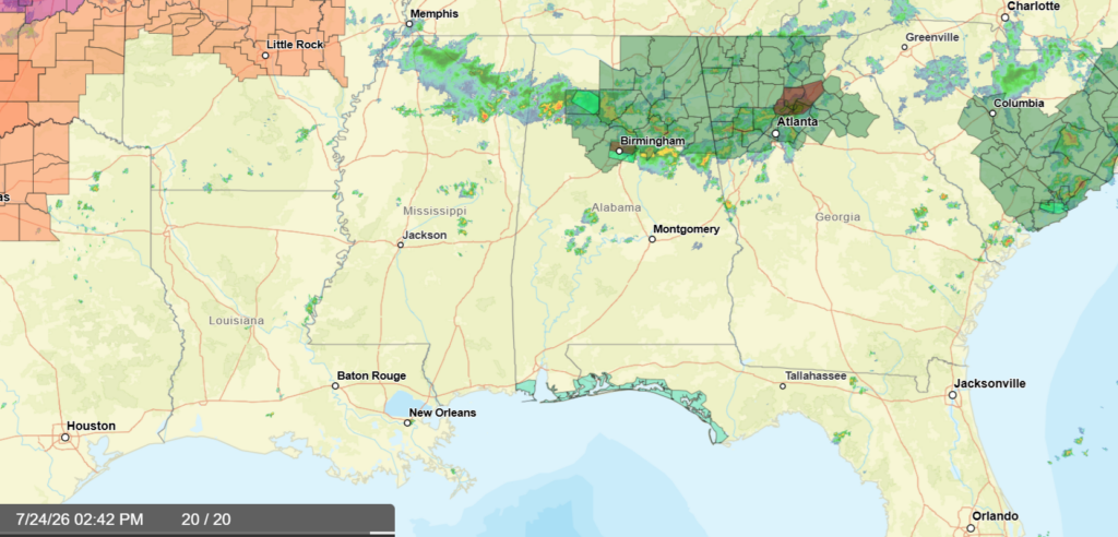
High pressure has once again moved into the region, keeping conditions hot for a good majority of us. A stalled frontal boundary out in the central/northern parts of Alabama and Georgia is triggering scattered showers and thunderstorms for the region, some cells producing heavy rain so a flood watch is in effect. This front will likely stall throughout the weekend and move out by Monday.
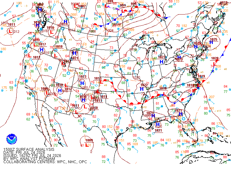
For everyone else, sunny and hot conditions is the name of the game for the next week, a chance of an isolated shower or thunderstorm exists each day as well, a sea breeze that will possibly occur tomorrow could trigger some showers and thunderstorms.
Heat risk becomes an increased concern for the next week or so. The highs will continue to climb and so will the heat index values. The high pressure will keep temperatures above normal, sunny conditions not doing much for any relief.
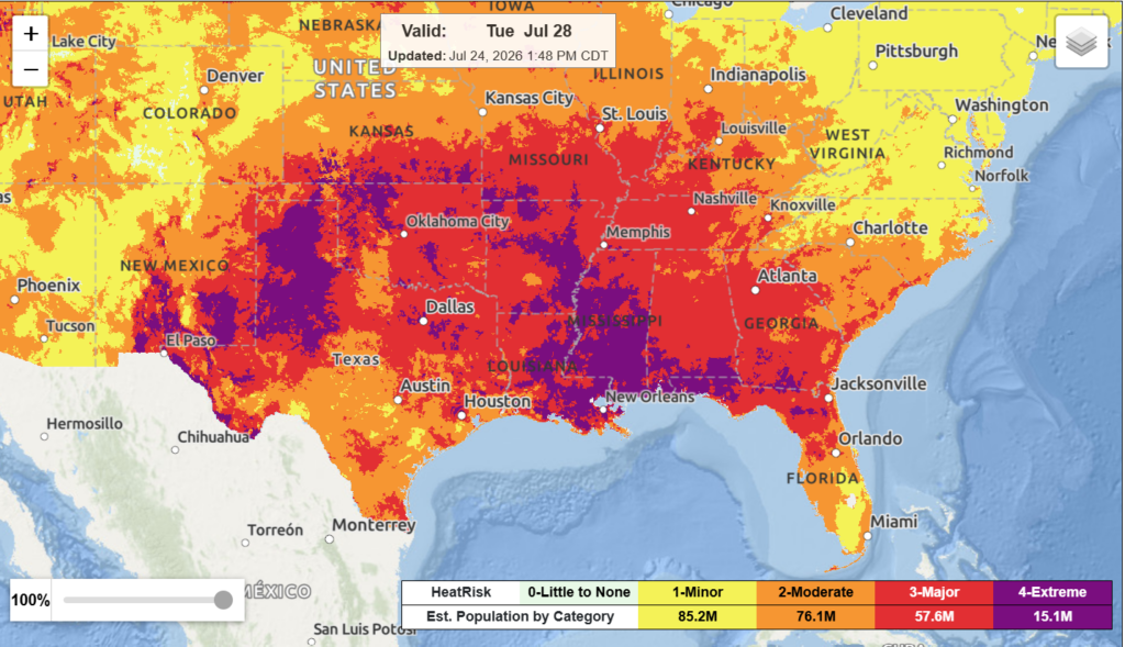
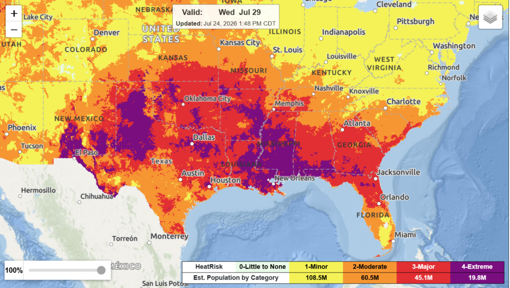
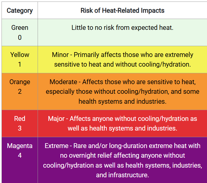
Above shows the heat risk outlook for Tuesday (on left) and Wednesday (right) next week. A good amount of the region falls under the major and extreme heat risk. Under these categories, it is not advised to be outside for periods of time without some way to cool off and stay hydrated. It is vital you take this seriously and keep cool.
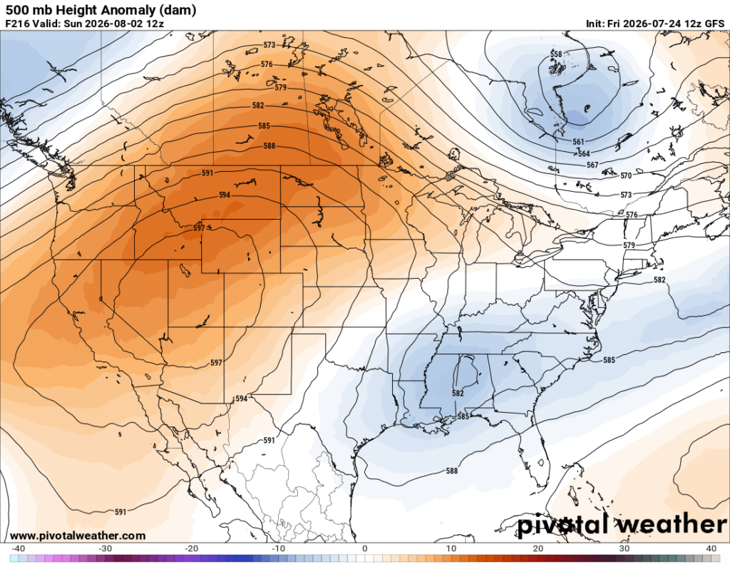
Isolated showers and thunderstorms are possible in the heat of each day, a more summer weather pattern you would typically expect for this time of year. Though it does seem there may be a bit of relief in the forecast by early August.

Model guidence points to the possibility of a trough extending into the region by the beginning of August, bringing with it some slightly cooler temperatures and chances to see rain and thunderstorms. We will continue to monitor this and see how this will affect the weather in our region!
3-DAY TRAVEL FORECAST
AIRPORTS
KIAH/KHOU (Houston) – No weather-related delays are anticipated. A slight chance for showers and thunderstorms exists today, but not significant enough for any delays.
KSHV (Shreveport) – No weather-related delays are anticipated. A slight chance for showers and thunderstorms exists today and tonight, but not significant enough for any delays.
KBTR (Baton Rouge) – No weather-related delays are anticipated.
KJAN (Jackson) – No weather-related delays are anticipated.
KMSY (New Orleans) – No weather-related delays are anticipated.
KMOB (Mobile) – No weather-related delays are anticipated.
KATL (Atlanta) – Brief delays due to lightning are possible each day, the greatest risk being today and tonight.
KTLH (Tallahassee) – No weather-related delays are anticipated. A chance for showers and thunderstorms exists tomorrow and Sunday, but not significant enough for any major delays.
KBHM (Birmingham) – Brief delays due to lightning are possible each day, the greatest risk being today and tomorrow.
HIGHWAYS
I-10 – These next few days look to be good travel days along I-10, though an isolated shower or thunderstorm cannot be ruled out in the afternoons.
I-20 – Scattered showers and thunderstorms are possible each day, especially in the afternoons. Some storms could produce heavy rain and frequent lightning, so be careful of that!
I-49 – Isolated to scattered showers and thunderstorms are possible each day, especially in central/northern Louisiana. Stronger thunderstorms could produce higher amounts of rainfall.
I-55 – Isolated to scattered showers and thunderstorms are possible each day, especially in the afternoons. Some storms could produce heavy rain and frequent lightning, so be careful of that!
I-59 – Isolated to scattered showers and thunderstorms are possible each day, especially in the afternoons. Some storms could produce heavy rain and frequent lightning, so be careful of that! The greatest chance of precipitation is today/this afternoon and tomorrow.
I-65 – Isolated to scattered showers and thunderstorms are possible each day, especially in the afternoons. The greatest chance of precipitation is today/this afternoon and tomorrow.
I-75 – Scattered showers and thunderstorms are possible each day, especially in the afternoons. The greatest chance of precipitation is today/this afternoon and tomorrow. Some heavy rainfall and lightning are likely in thunderstorms.
CITY FORECASTS
Houston, TX
Today/tonight – A 20% chance of showers and thunderstorms today. Other than that, mostly sunny skies with a high near 95, heat index values reaching as high as 105. Wind gusts up to 20 mph are possible. Tonight, partly cloudy skies with a low around 77.
Tomorrow – Mostly sunny with a high near 96 and heat index values reaching up to 104. For tomorrow night, partly cloudy skies and a low around 76.
Sunday – It is looking to be hot for Sunday! Sunny with a high in the upper 90s, reaching close to 100. Mostly clear for Sunday night with a low in the upper 70s.
Shreveport, LA
Today/tonight – A 20% chance of showers and thunderstorms. Other than that, partly sunny and hot conditions with a high near 95, heat index values reaching up to 105. Tonight, a slight chance of rain before 10pm. A low around 78 with partly cloudy skies.
Tomorrow – Partly sunny and hot conditions, a high near 96 and heat index values as high as 105. Tomorrow night, partly cloudy skies and a low around 77.
Sunday – Mostly sunny and hot conditions with a high in the upper 90s. Mostly clear for Sunday night with a low in the upper 70s.
Baton Rouge, LA
Today/tonight – Mostly sunny and hot conditions with a high near 96. Tonight, partly cloudy skies and a low around 75.
Tomorrow – Mostly sunny and hot with a high near 95. Tomorrow night, partly cloudy skies and a low around 76.
Sunday – Sunny and hot conditions with a high in the mid 90s and a low in the upper 70s with mostly clear skies Sunday night.
Jackson, MS
Today/tonight – Partly sunny with a high near 94 and heat index values as high as 106. Mostly cloudy tonight with a low around 75.
Tomorrow – Partly sunny skies with a high near 94 and heat index values as high as 103. Tomorrow night, partly cloudy skies with a low around 75.
Sunday – Mostly sunny skies with a high in the mid 90s. Mostly clear for Sunday night and a low in the mid 70s.
New Orleans, LA
Today/tonight – Mostly sunny with a high near 94. Tonight, partly cloudy skies with a low around 77.
Tomorrow – Clouds will increase throughout the day for tomorrow, the high will be near 94. Tomorrow night, mostly cloudy skies becoming mostly clear overnight, the low around 78.
Sunday – Sunny and hot conditions with a high in the mid 90s. Sunday night, mostly clear skies and a low in the upper 70s.
Mobile, AL
Today/tonight – Mostly sunny skies with a high near 95. Tonight, mostly cloudy skies and a low around 75.
Tomorrow – Hot conditions and mostly sunny skies, a high near 97. Heat index values could reach as high as 107, so drink plenty of water when outside! Tomorrow night, partly cloudy skies and a low around 76.
Sunday – Sunny and hot conditions with a high in the upper 90s and a low in the upper 70s. Partly cloudy skies for Sunday night.
Atlanta, GA
Today/tonight – Chance of showers and thunderstorms is 80%, up to half an inch of rainfall is possible. The high will be near 87 and the low around 73. Tonight, a 60% chance of precipitation mainly before 7pm.
Tomorrow – A 40% chance of showers and thunderstorms in the afternoon. Other than that, partly sunny skies and a high near 87. Wind gusts could reach up to 15 mph. Tomorrow night, a 30% chance of showers and thunderstorms mainly before 1am. Partly cloudy skies with a low around 74.
Sunday – A 40% chance of showers and thunderstorms in the early afternoon. Other than that, mostly sunny skies with a high in the upper 80s. Winds gusts could reach as high as 15 mph. Sunday night. mostly clear with a low in the mid 70s.
Tallahassee, FL
Today/tonight – Mostly sunny and hot conditions with a high near 98, heat index values reaching up to 105. Tonight, mostly cloudy skies with a low around 76.
Tomorrow – A 40% chance of showers and thunderstorms in the afternoon. Other than that, mostly sunny and hot conditions with a high near 95 and heat index values as high as 103. Tomorrow night, a slight chance of showers and thunderstorms before 9pm. Mostly cloudy skies and a low around 76.
Sunday – A 40% chance of showers and thunderstorms in the early morning then afternoon. Mostly sunny and hot conditions with a high in the mid 90s. Sunday night, a 30% chance of precipitation exists with partly cloudy skies and a low in the mid 70s.
Birmingham, AL
Today/tonight – A flood watch is in effect until later this evening. Chance of showers and thunderstorms is 90% for the day. The high will be near 84. Up to three quarters of an inch of rain is possible. Tonight, a 30% chance of precipitation exists before 10pm. Mostly cloudy with a low around 73.
Tomorrow – A 70% chance of showers and thunderstorms for tomorrow afternoon. Partly sunny skies and a high near 88. Up to a half inch is possible. Tomorrow night, a 50% chance of showers and thunderstorms, mostly cloudy skies and a low around 74.
Sunday – A 50% chance of showers and thunderstorms, mostly sunny skies and a high near 90. Sunday night, mostly clear skies and a low in the mid 70s.


