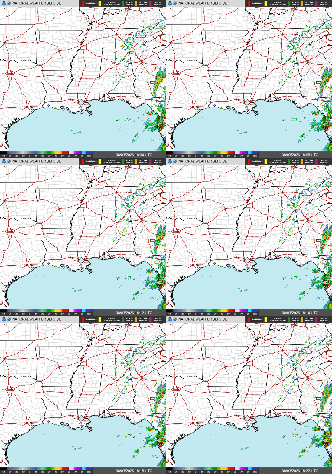
Looking at our regional outlook today, we see a mostly clear but warm Southern MS/AL/LA. Some stronger storms are impacting Florida and Georgia, with very isolated, short-lived showers traveling across Northern Alabama.
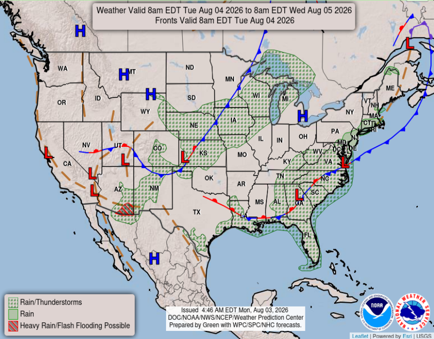
The lack of development of storms over our region isn’t the norm for this time of year. We currently have a front stalled out over the Southern part of our region, which will keep a majority of AL/MS/LA dry. The WPC graphic below shows Mississippi staying high and dry while LA and AL have a bit higher chance of seeing some showers, being on the edge of the dry air and stationary front.
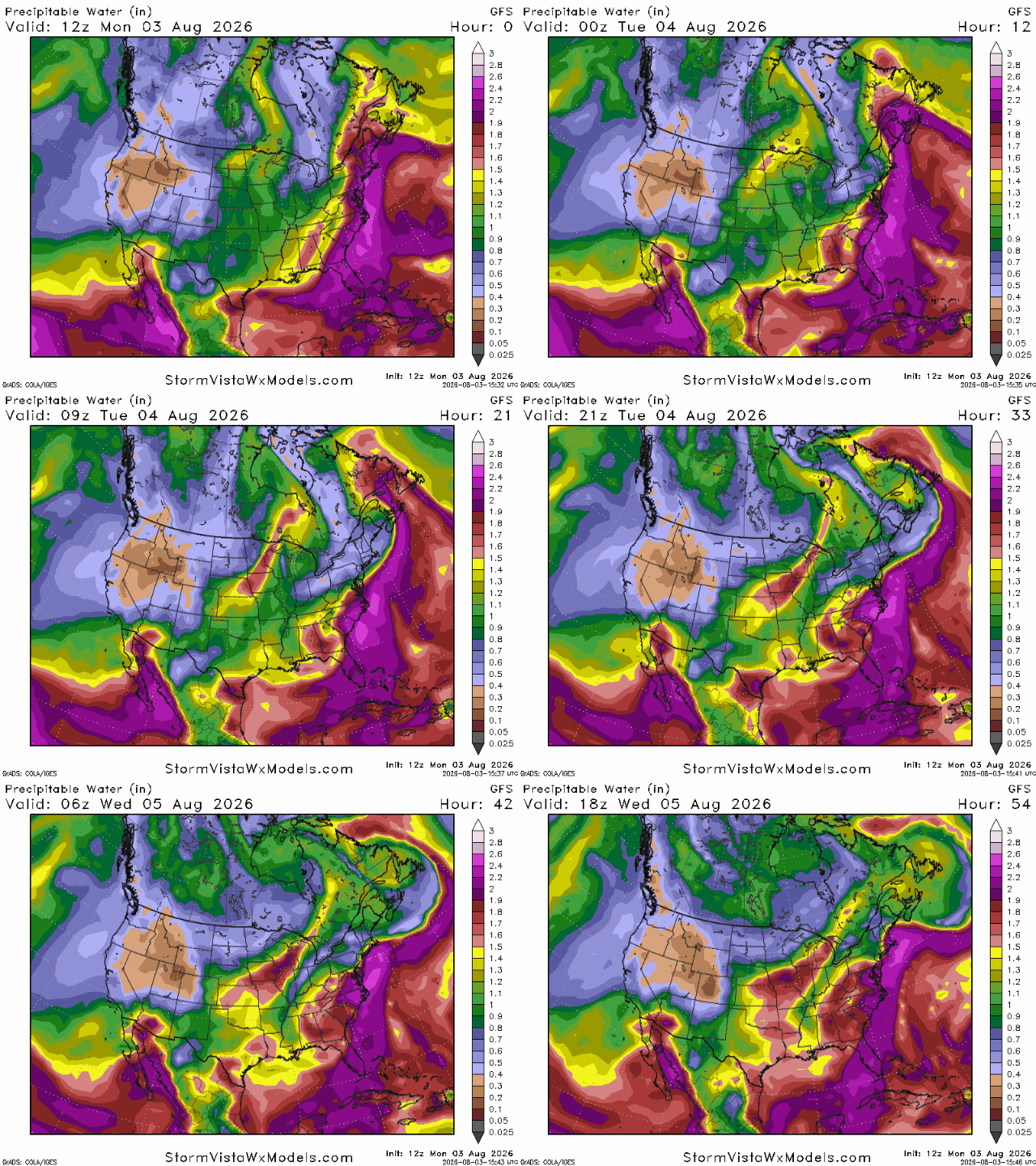
Also impacting our precipitation chances, we have an increase in dry air in the mid-levels of the atmosphere. As we can see below, this dry air limits the amount of moisture available for thunderstorms to develop and can weaken storms as they try to form. We can see this especially well with the green area centered over Mississippi, which indicates lower moisture content in the atmosphere compared to other areas across the South. This combination of the stationary front and dry mid-level air is helping to inhibit widespread storm development across the region.
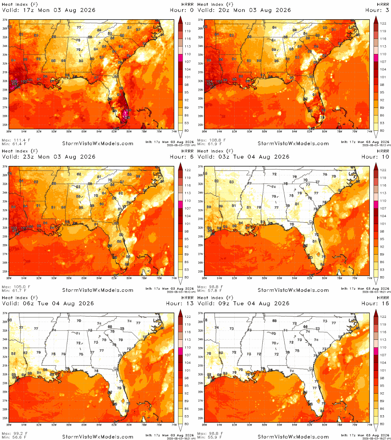
Looking below at our heat index, we do see that values will be impacted by the dry air and stationary front. Temperatures will be hot due to the lack of cloud cover and storm formation, but lucky for us, the humidity and dew point levels will be relatively low, meaning we won’t have as much of a sticky feeling from the humid air. Temperatures will still be high, especially in the sun, but having a little bit less humidity in the air and a lower dew point will allow our overnight low temperatures to creep into the low 70s across central MS.
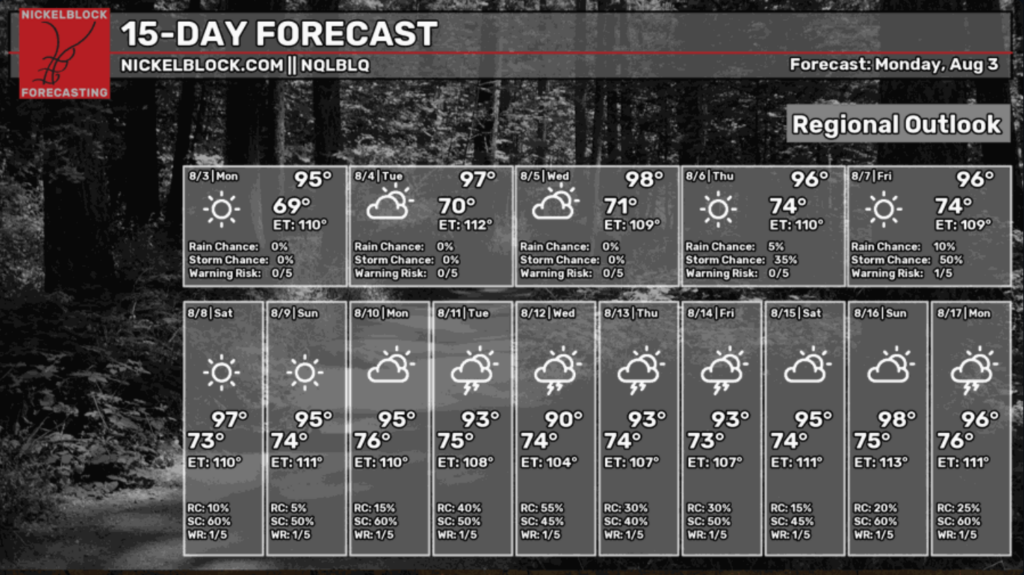
What this means for our 15-day regional forecast is storm chances lingering around 0% until Wednesday! Now this is a regional outlook, meaning that, as a whole, there will be very little precipitation across Southern AL/MS/LA. Still, some cities could receive rain, especially along the stationary front or farther West or East of MS. Temperatures will be warm still, but a decrease in humidity will hopefully keep the air from feeling as heavy as it normally does around this time and give us cooler nights for the next few days. Happy Monday!
3 Day Travel Forecast
AIRPORTS
KIAH / KHOU (Houston) – Low delay risk due to weather.
KSHV (Shreveport) – Low risk for delays.
KBTR (Baton Rouge) – Mostly clear and sunny, so low risk for weather-related delays.
KMSY (New Orleans) – Low delay risk due to weather.
KJAN (Jackson) – Low delay risk from weather.
KBMH (Birmingham) – Chance for delays in the afternoons as storms build.
KMOB (Mobile) – Low chance of delays due to weather.
KATL (Atlanta) – Delays are possible due to afternoon storms.
KTLH (Tallahassee) – Possible delays from afternoon thunderstorms.
Highways
I-10: Afternoon thunderstorms can be expected as you travel East.
I-20: Mostly clear and hot; afternoon thunderstorm risk increases as you travel East.
I-49: Mostly warm and clear.
I-55 & I-59: Hot temperatures with potential showers.
I-65: Warm with potential showers in the southern corridors.
I-75: Afternoon thunderstorms are to be expected and may turn severe at times.
3-Day City Forecast
Houston, TX: Monday (3rd): Hot with a slight chance of T-storms. High 99°F, low 80°F.
Tuesday (4th): Sunny with a 30% chance for afternoon showers. High 97°F, low 80°F.
Wednesday (5th): Warm and sunny with potential afternoon showers. High 96°F, low 80°F.
Shreveport, LA: Monday (3rd): Hot and clear. High 97°F, low 75°F.
Tuesday (4th): Hot and mostly clear. High 98°F, low 77°F.
Wednesday (5th): Warm and sunny, mostly clear. High 97°F, low 78°F.
Baton Rouge, LA: Monday (3rd): Warm and clear. High 92°F, low 75°F.
Tuesday (4th): Hot and sunny. High 96°F, low 76°F.
Wednesday (5th): Warm with potential afternoon storms. High 97°F, low 76°F.
New Orleans, LA: Monday (3rd): Sunny and clear. High 91°F, low 79°F.
Tuesday (4th): Mostly sunny. High 93°F, low 79°F.
Wednesday (5th): Hot with a chance for afternoon storms. High 93°F, low 79°F.
Jackson, MS: Monday (3rd): Sunny and mostly clear. High 92°F, low 70°F.
Tuesday (4th): Mostly sunny. High 94°F, low 71°F.
Wednesday (5th): Hot and clear. High 96°F, low 73°F.
Birmingham, AL: Monday (3rd): Slight chance of T-storms. High 86°F, low 70°F.
Tuesday (4th): Foggy in the morning with storms possible. High 88°F, low 72°F.
Wednesday (5th): Hot with a 40% chance for afternoon storms. High 89°F, low 73°F.
Mobile, AL: Monday (3rd): Mostly sunny and clear. High 92°F, low 75°F.
Tuesday (4th): Mostly sunny. High 94°F, low 77°F.
Wednesday (5th): Hot with a chance for afternoon storms. High 93°F, low 77°F.
Atlanta, GA: Monday (3rd): Slight chance of afternoon showers. High 87°F, low 71°F.
Tuesday (4th): Thunderstorms likely in the afternoon. High 87°F, low 71°F.
Wednesday (5th): Thunderstorms throughout the day. High 88°F, low 72°F.
Tallahassee, FL: Monday (3rd): Sunny with a chance of showers. High 88°F, low 72°F.
Tuesday (4th): Sunny with T-storms likely. High 91°F, low 73°F.
Wednesday (5th): Hot with a chance for afternoon storms. High 92°F, low 73°F.


