Not everyone will get a PM shower/storm, but those who do could see heavy rainfall, frequent lightning, and gusty winds. This activity will also help with the heat, keeping temperatures jusstt under heat advisory criteria this weekend.
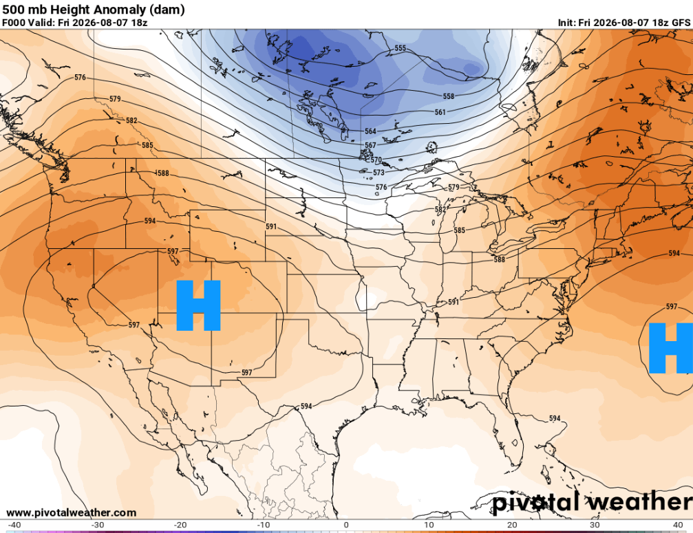
Two areas of high pressure remain on either side of us. With this pattern expected to hold through the weekend, temperatures should remain in the lower-90s with pop-up shower/thunderstorm activity peaking each afternoon.
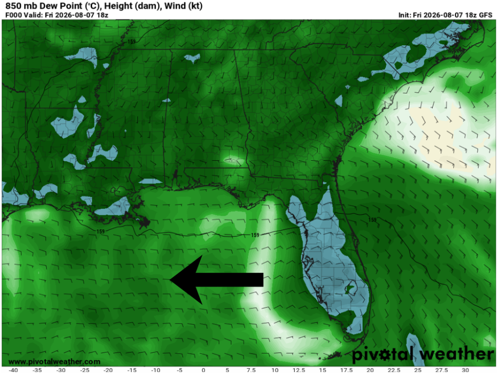
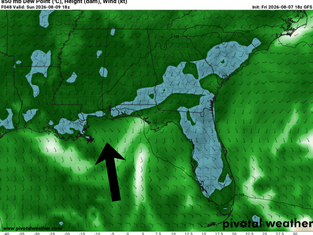
At the lower levels of the atmosphere, winds are generally out of the east today before becoming southerly on Sunday. This will help transport more moisture into the region and push the sea breeze farther inland. Meaning we could see higher storm coverage Sun-Mon along the Gulf coast.
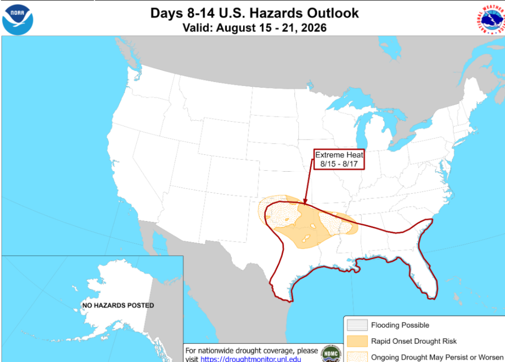
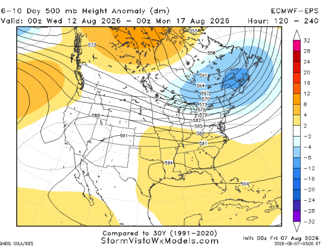
Looking ahead, ridging is expected to build over our region next week. For us, this means the return of drier weather and hotter temperatures (below right). The National Weather Service is already highlighting the return of extreme heat a week out (below left)!
3-DAY TRAVEL FORECAST
AIRPORTS
KIAH / KHOU (Houston) – Fog is possible overnight and into the early morning hours. Spotty storms are likely each afternoon, but aside from that, no major weather-related issues are anticipated through this weekend.
KSHV (Shreveport) – Spotty showers and storms possible each afternoon. Some intermittent flight delays are possible for lightning.
KBTR (Baton Rouge) – Spotty showers and storms possible each afternoon. Some intermittent flight delays are possible for lightning.
KMSY (New Orleans) – Afternoon showers and storms possible each day. Some intermittent flight delays are possible for lightning. But most flights between 5a and 12p should not be impacted by weather.
KJAN (Jackson) – Patchy fog and low clouds possible each morning right around sunrise, mainly in areas that receive a good amount of rain. Spotty storms are likely each afternoon, but aside from that, no major weather-related issues are anticipated through this weekend.
KMOB (Mobile) – Afternoon showers and storms possible each day. Some intermittent flight delays are possible for lightning. But most flights between 5a and 12p should not be impacted by weather.
KBMH (Birmingham) – Low-end chance of pop-up storms each afternoon. Some intermittent flight delays are possible for lightning. But most flights between 5a and 12p should not be impacted by weather.
KTLH (Tallahassee) – Afternoon showers and storms possible each day. Some intermittent flight delays are possible for lightning. But most flights between 5a and 12p should not be impacted by weather.
KATL (Atlanta) – Fog is possible overnight and into the early morning hours. Spotty storms are likely each afternoon, but aside from that, no major weather-related issues are anticipated through this weekend.
HIGHWAYS
I-10
Patchy fog is likely in Houston overnight and during the early morning hours.
Not too bad driving-wise, other than those pesky sea breeze storms.
Scattered showers/storms will develop early in the morning and move inland through the afternoon. Brief but sudden lightning, heavy downpours, and gusty winds are all possible. This will be the case from Houston to Tallahassee, with higher storm coverage expected Sunday
I-20
Patchy fog and low clouds possible each morning right around sunrise, mainly between Shreveport and Birmingham.
Mostly dry, but a few isolated storms are possible during the afternoon-evening timeframe. Any passing storms could bring brief heavy downpours, lightning, and gusty winds up to 40 mph.
I-49
Mostly dry, with afternoon isolated showers/thunderstorms possible along I-49, increasing in coverage as you drive south towards Lafayette.
I-55 & I-59
Fog is the main story here overnight and through 8am.
Mostly dry otherwise, with a few spotty storms possible during the afternoon. Better chances for storms as you head south toward the coast
I-65
Hit-or-miss storms are possible each day from Decatur to Mobile, with a better chance Sunday.
Patchy fog could make driving a little difficult overnight and during the early morning hours, mainly near Birmingham.
I-75
Saturday, scattered to numerous showers are likely as you drive south of the Florida border.
Sunday, hit-or-miss showers and storms are possible all along I-75. Passing storms could bring brief heavy downpours, lightning, and gusty winds up to 40 mph.
CITY FORECASTS
Houston, TX
Tonight – Partly cloudy skies tonight with patchy fog. Warm and muggy with calm winds. Low around 78.
Saturday – Patchy fog likely before 8am. Plenty of sunshine with a high of 93. Humidity sticks around, making it feel up to 103. Scattered storms are likely after lunchtime. Rain chance: 30%
Sunday – Mix of sun and clouds. High of 93 but will feel closer to 106. Humidity increases as well as shower/thunderstorm coverage. Light breeze from the east at 5-10mph. Rain chance: 40%
Shreveport, LA
Tonight – Thunderstorms possible overnight, but remaining clear for most. Temperatures mild tonight around 76. Calm wind. Rain chance: 15%
Saturday – Mix of sun and clouds with spotty storms possible around lunchtime. High of 94. Humidity will make it feel closer to 105. Rain chance: 20%
Sunday – Abundant sunshine. High of 93, will feel closer to 105. Can’t rule out a stray storm. Light breeze from the south at 5mph.
Baton Rouge, LA
Tonight –Quiet night under mostly clear skies. Low 75, light breeze from the southeast.
Saturday –Mix of sun and clouds with spotty storms in the evening. High 93, feeling closer to 105. Rain chance: 20%
Sunday – Plenty of sunshine. High of 93, will feel closer to 105. Light breeze from the southeast at 5mph. Better chance for scattered storms in the afternoon. Rain chance: 40%
New Orleans, LA
Tonight – Quiet night under mostly clear skies. Low 80 light breeze from the southeast.
Saturday –Mix of sun and clouds with spotty storms after lunchtime. High 91, feeling closer to 103. Rain chance: 20%
Sunday –Plenty of sunshine. High of 90, with humidity making it feel 10 degrees warmer. Light breeze from the east at 5mph. Better chance for scattered storms in the afternoon. Rain chance: 50%
Jackson, MS
Tonight –Storms are possible early tonight before giving way to cloudy skies with fog across the area. Low 73 and calm winds. Rain chance: 15%
Saturday –Patchy fog until 8am. Mix of sun and clouds with spotty storms in the late afternoon-evening timeframe. High of 95 but will feel closer to 105. Rain chance: 30%
Sunday –Plenty of sunshine. High of 95, humidity will make it feel 12 degrees warmer. Calm winds. Again, isolated showers and thunderstorms in the afternoon. Rain chance:40%
Birmingham, AL
Tonight –Lingering storms until midnight before settling into a quiet night with clear skies. Low around 73 with calm winds. Rain chance: 20%
Saturday –Typical summer weather. Mix of sun and clouds with a spotty storm or two in the afternoon. High 91. Rain chance: 30%
Sunday – Patchy fog possible in the early morning hours. Cloudy skies with a high near 92. Again, isolated showers and thunderstorms are possible in the afternoon. Rain chance: 30%
Mobile, AL
Tonight – Quiet night under clear skies. Low around 75 with calm winds.
Saturday – Typical summer weather. Mix of sun and clouds with a spotty storm or two in the afternoon. High 94, will feel closer to 105. Light breeze from the northeast at 5mph. Rain chance: 20%
Sunday – Humidity increases, along with shower and thunderstorm coverage. Mostly sunny skies expected with hit-or-miss storms around lunchtime. High 91, will feel closer to 105. Light breeze from the east at 5mph. Rain chance: 50%
Tallahassee, FL
Tonight – Some lingering storms lasting until sunset before settling into a partly cloudy night. Low of 74. Rain chance: 15%
Saturday – Sunny with coastal showers in the morning, followed by afternoon and evening showers and thunderstorms moving inland. High of 90, feeling closer to 102. Light breeze from the northeast. Rain chance: 50%
Sunday – Hit-or-miss showers and thunderstorms. Otherwise, partly cloudy skies with a high of 92, will feel closer to 105. Rain chance: 50%
Atlanta, GA
Tonight –Partly cloudy with a lingering shower. Temperatures dropping down to 72. Calm wind. Rain chance: 20%
Saturday – Patchy fog possible early morning, mainly in areas that received rain. Plenty of sunshine with evening isolated showers and thunderstorms. High of 90. Light breeze from the southeast. Rain chance: 30%
Sunday – Patchy fog possible around sunrise. Mix of sun and clouds with a brief passing storm or two possible around lunchtime. High 92, may feel closer to 100. Rain chance: 20%


