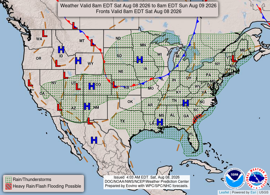
There is an area of high pressure sitting in southern MS, which will feed the area with warm, moist air from the Gulf. This setup will allow for afternoon and early evening thunderstorms to develop along the coast. As for the southeastern coast, there is an extended area of low pressure. This will allow for heavier rainfall and thunderstorms, especially in GA and SC.
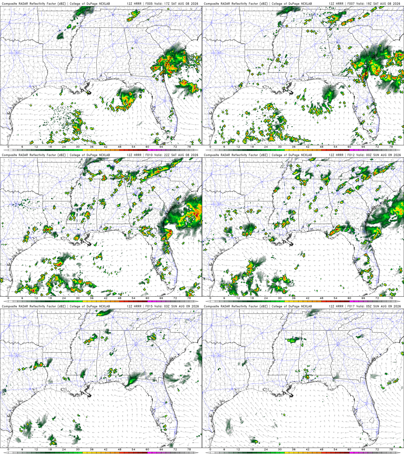
Tonight
Isolated to scattered showers throughout the region. Heavier rainfall is concentrated in GA and SC. Around nighttime hours, conditions will begin to calm.
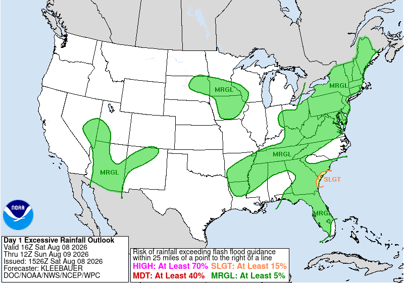
There is a marginal risk of excessive rainfall across most of our region, which means localized flash flooding is possible. Along the GA and SC coasts, there is a slight risk, meaning a higher chance of localized flash flooding, especially if you live in a flood-prone area. Make sure to stay weather aware!
Today’s Interstate Forecast
I-10: Scattered showers and thunderstorms in FL, LA, and western TX. Mostly clear by nighttime hours with possible isolated thunderstorms in southern AL.
I-20: Scattered showers and thunderstorms throughout our region. Clearing up around nighttime hours. Possible isolated showers near the LA/ TX border.
I-49: Isolated thunderstorm near northern LA. Will clear up by nighttime hours.
I-55: Isolated to scattered showers and thunderstorms, especially near the MS/ LA border. Will clear up by nighttime hours.
I-59: Isolated to scattered showers and thunderstorms. Will start to clear up around late evening.
I-65: Isolated to scattered showers and thunderstorms. Southern AL will continue to have isolated thunderstorms around nighttime hours.
I-75: Scattered showers and thunderstorms. Will clear up by nighttime hours.
3 Day Traveling Forecast
KHOU – Houston: Chance of thunderstorms all three days. Possible delays at the airport due to lightning.
KSHV – Shreveport: Chance of thunderstorms today and tomorrow. Possible delays at the airport due to lightning.
KBTR – Baton Rouge: Chance of thunderstorms Sunday and Monday. Possible delays at the airport due to lightning.
KMSY – New Orleans: Chance of thunderstorms all three days. Possible delays at the airport due to lightning.
KJAN – Jackson: Chance of thunderstorms all three days. Possible delays at the airport due to lightning.
KBHM – Birmingham: Chance of thunderstorms all three days. Possible delays at the airport due to lightning.
KMOB – Mobile: Chance of thunderstorms all three days. Possible delays at the airport due to lightning.
KATL – Atlanta: Chance of thunderstorms all three days. Possible delays at the airport due to lightning.
KTLH – Tallahassee: Chance of thunderstorms Sunday and Monday. Possible delays at the airport due to lightning.
3 Day City Forecast
Houston, TX:
Today – Chance for thunderstorms during the day. High of 94 F. Mostly clear overnight. Low of 78 F. Relatively calm winds.
Sunday – Chance for thunderstorms during the day. High of 93 F. Mostly clear overnight with a slight chance for thunderstorms. Low of 78 F. Relatively calm winds.
Monday – Chance for thunderstorms during the day. High of 91 F. Mostly clear overnight. Low of 79 F. Relatively calm winds.
Shreveport, LA:
Today – Chance for thunderstorms during the day. High of 95 F. Partly cloudy overnight with a slight chance of thunderstorms. Low of 76 F. Calm winds.
Sunday – Mostly sunny with a chance for thunderstorms during the day. High of 94 F. Partly cloudy overnight. Low of 77 F. Calm winds.
Monday – Sunny during the day. High of 94 F. Mostly clear overnight. Low of 77 F. Calm winds.
Baton Rouge, LA:
Today – Mostly sunny during the day. High of 94 F. Mostly clear overnight. Low of 75 F. Calm winds.
Sunday – Sunny with a chance for thunderstorms during the day. High of 94 F. Mostly clear overnight with a chance for thunderstorms. Low of 75 F. Calm winds.
Monday – Thunderstorms likely during the day. High of 92 F. Mostly clear overnight, with thunderstorms likely. Low of 76 F. Calm winds.
New Orleans, LA:
Today – A slight chance of thunderstorms during the day. High of 91 F. Mostly clear overnight. Low of 78 F. Calm winds.
Sunday – Heavy rain and thunderstorms during the day. High of 90 F. Mostly clear overnight with heavy rainfall. Low of 79 F. Calm winds.
Monday – A chance of thunderstorms during the day. High of 90 F. Mostly clear overnight with a chance of showers. Low of 79 F. Calm winds.
Jackson, MS:
Today – Scattered thunderstorms during the day. High of 94 F. Mostly clear overnight with a chance for thunderstorms. Low of 73 F. Calm winds.
Sunday – Chance of thunderstorms during the day. High of 95 F. Mostly clear overnight with a slight chance of thunderstorms. Low of 74 F. Calm winds.
Monday – Mostly sunny with a slight chance of thunderstorms during the day. High of 95 F. Mostly clear overnight. Low of 75 F. Calm winds.
Birmingham, AL:
Today – Chance of thunderstorms during the day. High of 91 F. Partly cloudy overnight with a slight chance of thunderstorms. Low of 73 F. Calm winds.
Sunday – A slight chance of thunderstorms during the day. High of 91 F. A slight chance of thunderstorms overnight. Low of 74 F. Calm winds.
Monday – A slight chance of thunderstorms during the day. High of 90 F. A slight chance of thunderstorms overnight. Low of 74 F. Calm winds.
Mobile, AL:
Today – A slight chance of thunderstorms during the day. High of 95 F. Mostly clear with a slight chance of thunderstorms overnight. Low of 76 F. Calm winds.
Sunday – A chance of thunderstorms during the day. High of 92 F. Mostly clear overnight. Low of 77 F. Calm winds.
Monday – A chance of thunderstorms during the day. High of 91 F. Mostly clear overnight. Low of 77 F. Calm winds.
Atlanta, GA:
* Scattered showers and thunderstorms are expected this afternoon and evening. A few storms may be capable of gusty winds, frequent lightning, and locally heavy rainfall. Isolated flash flooding will be possible. (NWS)
Today – A slight chance of thunderstorms during the day. High of 91 F. Mostly clear with a slight chance of thunderstorms overnight. Low of 73 F. Calm winds.
Sunday – Sunny with a chance of thunderstorms during the day. High of 91 F. Partly cloudy overnight with a chance for thunderstorms. Low of 74 F. Calm winds.
Monday – A chance of thunderstorms during the day. High of 90 F. A slight chance of thunderstorms and showers overnight. Low of 74 F. Calm winds.
Tallahassee, FL:
Today – A chance of showers during the day. High of 91 F. Mostly clear with a chance of showers overnight. Low of 75 F. Calm winds.
Sunday – A chance of showers and thunderstorms during the day. High of 92 F. Partly cloudy overnight. Low of 75 F. Calm winds.
Monday – A chance of thunderstorms during the day. High of 93 F. Mostly clear overnight with a chance of thunderstorms. Low of 75 F. Calm winds.
Extended Regional Outlook
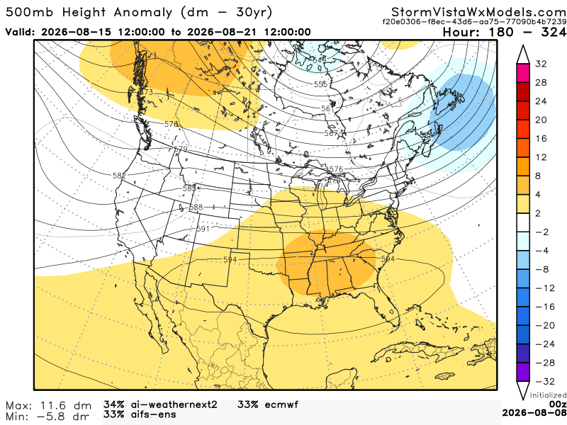
The CPC outlook indicated that our area would experience above-average temperatures and slightly below-average precipitation.


This 500mb height anomaly model is a blend of the 3 most accurate models over the past 7 days. The model runs from August 15, 7 am to August 21, 7 am. Based on the blend, I would agree with CPC. Our area has a strong positive anomaly, meaning warmer temperatures and less precipitation. A positive anomaly is associated with sinking air, making it unfavorable for precipitation and creating a heat dome over the area.